|
GENERAL STATEMENT OF DUTIES
Responsible for creating and maintaining geographic information system (GIS) databases, translating geographic and demographic data, programming, testing, configuring, updating, documenting, monitoring, evaluating, and/or supporting GIS systems software. Works under general / limited supervision on basic and more complicated routine GIS analytical/programming/systems projects with project deadlines. Serves as technical consultant to computing professionals, users and departmental management. SUPERVISION RECEIVED Works under the general supervision of a higher-level professional employee who assigns work, establishes goals, and reviews work for conformance to technical standards and compliance with department goals and is considered the journey level in this series. SUPERVISION EXERCISED Supervision of other employees is not a responsibility of positions in this classification, although employees in this class may serve in a project lead capacity. Typical Duties - Duties include, but are not limited to the following GIS Development
GIS User Support
GIS Administration
Consulting & Training
EXPERIENCE AND TRAINING Bachelor's degree in geography, planning, computer science, landscape architecture, or related field; AND Three years of experience in the application of Environmental Systems Research Institute (ESRI) software; OR Any satisfactory combination of work, education, training, or experience relevant to the position, as determined by Marion County. SPECIAL REQUIREMENTS The finalist for this position will be required to pass a criminal history background check, including finger printing; however, conviction of a crime may not necessarily disqualify an individual for this position. This assignment is represented by a union. This is a full-time position, which is eligible for overtime. Typical Work Schedule: Monday through Friday, days, with flexibility depending upon the needs of the department and program. KNOWLEDGE, SKILLS AND ABILITIES Considerable knowledge of applications programming techniques, systems maintenance and security; application development tools; principles and practices of data communication; computer hardware and systems software in supporting application systems; database management systems, principles and techniques; applicable computer programming languages. ESRI software and computer mapping techniques; data integrity control; legal descriptions pertaining to land ownership; cadastral principles; research methods to determine right of way and ownership history; principles of geographic mapping and cartography, mathematics, statistics and spatial data analysis. Skill and abilities to establish controls and security measures; code, test and document applications; plan and coordinate program efforts to achieve data processing requirements and objectives; develop and implement data processing projects. Provide technical assistance or train others in the use of computer hardware and software; resolve user problems; communicate effectively with user divisions and technical staff; create and maintain databases; write computer programs for the creation of mapping products; digitize cartographic data. Operate and use personal computers and various other computer aided devices such as digitizers, scanners and plotters; define programming sequencing necessary to produce maps; interpret legal documents and translate legal descriptions into the database; distinguish gradations of color; understand and respond to mapping requests from the public; read, understand and work with a variety of mapping data; organize and write worksite instructions and procedures; code, test, debug, maintain and install computer applications and modify applications according to worksite requirements; establish and maintain effective working relationships with coworkers, the public and other agencies. PUBLIC SERVICE LOAN FORGIVENESS Marion County is a qualifying public employer for the Public Service Loan Forgiveness Program. Through the Public Service Loan Forgiveness Program, full-time employees working at the County may qualify for forgiveness of the remaining balance on Direct Loans after 120 qualifying monthly payments under a qualifying repayment plan. Questions about your loan eligibility should be directed to your loan servicer or the US Department of Education. VETERANS’ PREFERENCE Applicants are eligible to use Veterans’ Preference when applying with Marion County in accordance with ORS 408.225, 408.230, and 408.235 and OAR 105-040-0010 and 105-040-0015. Preference will be awarded only if the applicant meets the minimum requirements of the position and attaches the required documentation at the time of application. HOW TO APPLYhttps://www.governmentjobs.com/careers/marion/jobs/4463949/gis-analyst-2 FFN Surveying is seeking a skilled Land Surveyor to join our team. As part of this position, you will be responsible for the collection and analysis of survey data with the possibility of expanding into an integrated office position. This is an excellent opportunity for someone with a strong background in land surveying and data analysis skills within a growing company.
Responsibilities: - Conduct land surveys using various surveying equipment and tools - Collect and record survey data accurately and efficiently - Perform calculations and data analysis - Collaborate with the surveying team to ensure project deadlines are met - Perform lifting and physical tasks as required for field work Qualifications: - Minimum 2-3 years of Land Surveying experience required. - Proficient in Trimble Robotic Total Stations, GPS and Data Collection Software. Expedience in AutoCad Civil 3d a bonus. - Excellent attention to detail and accuracy in data collection and analysis - Ability to work both independently and collaboratively as part of a team - Strong problem-solving skills and ability to think analytically - Effective communication skills, both verbal and written Benefits: - Competitive salary based on experience and qualifications - Health insurance coverage - Paid time off and holidays If you meet the qualifications for this position and are looking for an exciting opportunity, please submit your resume for consideration. We look forward to reviewing your application. Please submit all applications to: showell@ffnsurveying.com i.e. Engineering, Inc. is seeking a full-time Land Survey Technician to join our team. This position will be primarily office and computer operations, with the occasional need to lead or be a member of the field survey crew.
Job Responsibilities:
Our ideal candidate will have LSIT certificate or be working towards certificate with the goal of becoming professionally licensed. Candidate will also have a valid driver’s license and clean driving record. Demonstration of problem-solving skills, good written and oral communication skills and working as part of a multidisciplinary team will be necessary. i.e. Engineering, Inc. has proudly provided professional services to the greater Southern Oregon area since 1991. Our locally owned company is a well-respected and active participant in the Roseburg and surrounding area communities. We offer our clients a professional, local option, for their Civil Engineering and Land Survey needs. i.e. Engineering, Inc. offers employees a generous benefit package that includes paid holidays, vacation, paid health/dental, long term care and disability and paid family medical leave insurance, as well as a monthly retirement account contribution. Compensation for this position is dependent on the applicant’s qualifications and experience. Please email resume to jranger@ieengineering.com to apply. Closing date: 2024-05-05
Position: Conservation Technology Associate, California Organization: The Nature Conservancy Country: United States State: California Contact: Brian Cohen Contact Email: applyhelp@tnc.org https://careers.nature.org/psp/tnccareers/APPLICANT/APPL/c/HRS_HRAM_FL.HRS_CG_SEARCH_FL.GBLPage=HRS_APP_JBPST_FL&Action=U&FOCUS=Applicant&SiteId=1&JobOpeningId=55015&PostingSeq=1 Description The Conservation Technology Associate's work will support every program and many conservation strategies across TNC California, and will entail collaboration with many Conservation Technology colleagues. This role is responsible for processing spatial and relational data sets, performing data analysis, and creating cartographic and data visualization products. They also build, maintain, and populate data and record databases, and maintain a shared GIS library and database products library. Their role includes developing, analyzing, and managing data sources in various formats. They digitize and clean large datasets, manipulate data, and conduct quality assurance reviews and tests on data. They provide spatial analysis, maps, charts, and reports to support planning and prioritization efforts, and publish data to the web, creating web maps and web applications. They assist the team with project management as needed and curate GIS data, Esri .aprx documents, and Python code. May work in variable weather conditions, at remote locations, on difficult and hazardous terrain and under physically demanding circumstances. About Organization The Nature Conservancy (TNC) is a global conservation organization dedicated to conserving the lands and waters on which all life depends. Grounded in science, we develop innovative solutions to the world’s toughest environmental challenges so that people and nature can thrive. Our work is guided by our values, which include a commitment to diversity; respect for people, communities, and cultures; and a collaborative, nonpartisan approach. Thanks to more than 1 million members, over 400 scientists, and the dedicated efforts of our staff and partners, we impact conservation around the world. The California Chapter is TNC’s largest state program and one of the largest, most dynamic conservation organizations in the country. With approximately 275 employees, from financial analysts and fundraisers to ecologists and economists, we are currently invested in 14 strategies to address the biggest challenges facing California and the world, including numerous community-based projects designed to increase the pace, scale, and effectiveness of conservation. Over the past six decades, we have protected 1.4 million acres, 5,000 miles of streams, and 3.8 million acres of ocean habitat in California and off the coast. The California Chapter believes that we are most effective when we are embedded in our state’s communities, politics, media, and environmental issues. For this reason, and to reduce our carbon footprint when meeting in person, all staff live in California, including those in a home office. Finally, we are passionate about the middle ground in American politics and life. The hallmark of The Nature Conservancy is its “big tent” approach, engaging people across the political and ideological spectrum to find solutions that last. We ask all employees to embrace this critical strategic position of our organization. The National Park Service, Alaska Region, just announced a 6-month (plus) internship opportunity to assist with GIS in support of a stream restoration project in Yukon-Charley Rivers National Preserve. See the attached announcement for details. Applications due by April 20. https://www.suu.edu/iic/internships/ 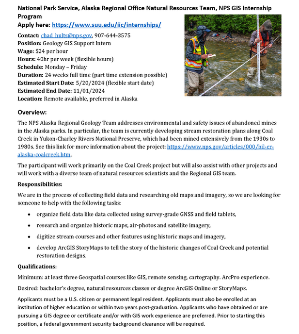 GIS and Data Systems Specialist (TPS4) w/ State of Washington Dept. of Transportation (Seattle)4/9/2024
About WSDOT
Washington State Department of Transportation (WSDOT) is the steward of an integrated, multimodal transportation system that helps to ensure people and goods move safely and efficiently throughout the state. In addition to building, maintaining, and operating the state highway system, WSDOT operates the largest ferry system in the nation, manages the world's longest floating bridge, and recently completed the world's widest tunneling project. The Opportunity WSDOT’s Active Transportation Division is currently seeking a Transportation Planning Specialist 4 to serve as a GIS and Data Systems Specialist in Seattle, WA. This specialist will serve as the geospatial data development and data management lead for the division, and provide analytical support for capital projects, active transportation funding programs, and other programs serving active transportation users. The top candidate will also provide general geospatial and data analysis support to the Active Transportation Division including establishing and facilitating effective data storage and retrieval systems, consistent with lean data principles, industry best practices, and agency geospatial data standards. Additionally, this position will serve as the liaison to WSDOT’s Transportation Data and GIS Office (TDGO) and Technology Services Division (TSD) groups and as the agency’s trails and paths data coordinator. What to Expect This is a highly collaborative position, involving teams both inside and outside of the agency. The chosen candidate will have a central role in shaping active transportation data development and data management for the agency. Many tasks will require creative solutions and iterative approaches to both support ongoing agency work and to advance the state of practice with respect to active transportation data and geospatial analysis. Among the varied range of responsibilities held within this role, the GIS and Data Systems Specialist will:
Qualifications To be considered for this opportunity, the following are required:
It is preferred that qualified candidates also have:
Important Notes
Why WSDOT
HOW TO APPLY: https://www.governmentjobs.com/careers/washington/jobs/4455480/gis-and-data-systems-specialist-tps4 Due to the specialized nature of this work, we are going to leave this recruitment open until May 31, 2024 with the first review of applications beginning at 8AM on April 15, 2024. Please note, this recruitment may close anytime after that first review date.
If you enjoy the outdoors, Oregon’s Willamette Valley is the place for you. It is less than an hour from glaciated mountain peaks to the east, the Pacific Ocean to the west and the massive Columbia River Gorge to the north. You can fish 365 days a year, and there is hunting for big game, waterfowl and game birds. The Oregon coast attracts thousands of people who clam, crab and fish in the ocean for halibut, salmon and tuna. The outdoor opportunities are endless when it comes to fish and wildlife in Oregon! If culture is what you seek, the Willamette Valley is the most populated area in Oregon and contains its three largest cities: Salem, Portland and Eugene, which are home to many museums and theaters. The Valley is also known for its vineyards, breweries and fantastic casual dining experiences. To learn more about the department and the work we do, view the following video at https://myodfw.com/about To see examples of some of the maps we produce, please visit https://www.dfw.state.or.us/maps/index.asp What you will do:
Working Conditions
Criminal Records/DMV Check Applicants are subject to both a criminal history and motor vehicles check. Out-of-state finalists will be required to present a current certified driving record for review to be considered for the position. Be prepared to obtain as soon as possible. You are expected to provide the out-of-state certified driving record before an offer can be made unless extenuating circumstances exist. Adverse background information may disqualify you from further consideration. NOTE: Within three days of hire, applicants will be required to complete the U.S. Department Homeland Security's I-9 form confirming authorization to work in the United States. ODFW participates in E-Verify. ODFW is not able to support VISA sponsorships. We are seeking applicants who meet the minimum qualifications and have the following skills and experience: Minimum Qualifications:
Requested Skills:
HOW TO APPLY: https://oregon.wd5.myworkdayjobs.com/en-US/SOR_External_Career_Site/job/Salem--ODFW--Headquarters/Information-Systems-Specialist-4--NRIMP-GIS-Technician----Temporary_REQ-153300 https://conservationdistrict.org/2024/new-weedwise-technician-2024.html
WeedWise Technician (Seasonal)The WeedWise Technician is a full-time, seasonal (1040 hours), at-will position that will assist with surveying and managing invasive weeds. Successful candidates will assist with WeedWise Program activities and initiatives as required. Successful applicants will demonstrate:
Additionally, successful applicants will have:
Closing date: 2024-04-19
Position: Spatial Analyst Organization: Earth Insight Country: United States State: California Contact: Bart Wickel Contact Email: hiring@earth-insight.org Description: Spatial Research Analyst We are seeking a highly motivated Spatial Analyst to support the development of spatial tools and analytical approaches to qualify and quantify the future threats and ongoing impacts posed by future extractive industry development. The Position: The Spatial Analyst reports to the Science and Research Director and works collaboratively with other team members to gather, process, and analyze spatial data, and produce high-quality maps, novel visualizations and reports. You will also assist with the preparation of communication products that support Earth Insight’s engagement efforts with partner organizations and at key international fora including but not limited to Conference of Parties (COP) of the United Nations Framework Convention on Climate Change (UNFCCC) and the Convention of Biological Diversity CBD). The ideal candidate has a can-do attitude, is committed to contributing to meaningful change at a local to global level and has a curiosity about exploring new methods for analyzing and visualizing data. Demonstrable experience with Geographic Information Systems (GIS) is required and familiarity with open-source tools and libraries for spatial analysis and management and web mapping (e.g. Leaflet, Mapbox etc.) strongly appreciated. This is a full-time exempt position and is open to those authorized to work in the U.S. The position is fully remote based in the U.S. Key Responsibilities: - Perform data collection, analysis, and visualization using QGIS and other GIS software - Manage and maintain spatial databases, including data entry, data quality control, and data organization - Conduct spatial/GIS based data analyses to identify the threats associated with mining, oil and gas development and other drivers impacting local to global ecosystems, climate, biodiversity, and people - Produce high-quality maps, innovative data visualizations, and reports - Work collaboratively with other team members to provide support for various projects and cross-program priorities (ex: press strategy) as needed Qualifications: - Bachelor’s or Master’s degree in Geography, Environmental Science, or related areas - Demonstrable experience with GIS software, specifically QGIS and related software packages (QGIS/GDAL) - Demonstrable experience with at least one scripting language (Python, R, etc.) - Strong analytical and problem-solving skills - Excellent written and oral communication skills - Ability to work independently and as part of a team - A strong interest in environmental justice issues - Willingness to work on an adaptive schedule to accommodate calls with project partners across different time zones as needed Diversity, Equity, and Inclusion: RLF is committed to creating and maintaining a work environment free from discrimination, where all team members feel valued, respected, and included. We are an equal opportunity employer and welcome applications from all qualified candidates, whatever their race, color, creed, national origin, ancestry, sex, gender, sexual orientation, age, disability status, religious or political affiliation, marital status, or any other dimension of diversity. We know that our work is enriched by the varied voices and perspectives of every staff and board member, so we are committed to making an earnest effort to recruit, welcome, train, develop, and retain talented individuals from diverse backgrounds. We believe that a diverse and inclusive culture expands our creative capacity to do our work and achieve greater outcomes for people and the natural world. We invite you to learn more about RLF’s commitment to diversity, equity, and inclusion on our **[website](https://resourceslegacyfund.org/diversity-equity-inclusion/)**. Compensation: RLF is committed to providing competitive compensation and a total rewards package that emphasizes both base salary and comprehensive benefits. The starting salary range for this role is $65,000-$85,000. Offers are based on qualifications and experience and our practice of maintaining salary equity within our organization. We have an alternate Fridays off work schedule (employees work 40 hours one week, 32 hours the next week) and offer a comprehensive benefit package including medical, dental, and vision insurance, 401k plan with up to a 5% match, and generous paid time off including approximately 17 paid holidays per year. RLF also offers a technology allowance, student loan repayment assistance, the Calm app, mental health benefits, and fertility and adoption/surrogacy benefits. To Apply Please provide a resume, map product and/or coding portfolio (e.g. github, map stories etc.) and cover letter in PDF format explaining how your skills and experience align with this position to [hiring@earth-insight.org](mailto:hiring@earth-insight.org) and specify your name and position you are applying for in the subject line. The application deadline is April 19th, 2024. About Organization About Earth InSight and the Resources Legacy Fund: Earth Insight’s mission is to create transparency in existing and future plans for the expansion of extractive industries (fossil fuel extraction and mining specifically) and map potential threats to people, nature and climate in the world’s most vulnerable and intact places. Through the development of web-based mapping tools and innovative analytics founded on open-data and open-access data and code, we aim to arm communities and the environmental movement with ways to increase political and financial pressure and stop new fossil fuel and other destructive extractive industry developments, while charting alternative development pathways that respect biodiversity, human rights, and a stable climate. Earth Insight is a fiscally sponsored project of Resources Legacy Fund (RLF) based in Sacramento, California. RLF builds alliances that advance bold solutions to secure a just and resilient world for people and nature. RLF partners with philanthropy, community groups, government, science, and business to promote smart policies and ensure equitable public funding that protect nature, address the climate crisis, and advance environmental equity and justice. Across the American West and internationally, RLF manages complex, multi-year grantmaking programs and fiscally sponsored projects that accelerate change on environmental and equity issues. About the Position
The GIS Analyst is responsible for the operation and maintenance of the District’s Geographic Information System (GIS) and work order management systems, and for providing a high level of technical support, and services to personnel in digital mapping and District asset management. NOTE: Based on qualifications and experience, candidates may be considered for either the GIS Analyst or Senior GIS Analyst position. (Click the link to Senior GIS Analyst for a full job description) Essential Duties and Responsibilities include the following. Other duties, responsibilities, and activities may change or be assigned at any time with or without notice.
Position Requirements To perform this job successfully, an individual must be able to perform each essential duty satisfactorily. The requirements listed below are representative of the knowledge, skill, and/or ability required. Reasonable accommodations may be made to enable individuals with disabilities to perform the essential functions. Supervisory Responsibilities: This position has no supervisory responsibilities. Education and/or Experience: Associate's degree in geographic information systems, geography, planning or computer science; and a minimum of three (3) years of experience related to GIS systems; or equivalent combination of education and experience. Utility experience preferred. Certificates, Licenses, or Registrations: Must have a valid Driver’s license. ESRI Technical or GISP Certification preferred. Computer Skills: To perform this job successfully, an individual must be proficient in MS Outlook, Excel, and Word. Experience with ESRI, relational database management, and Internet-based applications preferred. Physical Demands: The physical demands described here are representative of those that must be met by an employee to successfully perform the essential functions of this job. While performing the duties of this Job, the employee is frequently required to walk, climb stairs, bend, reach, use hands to finger, handle, and feel, and sit for extended periods of time. Occasionally required to lift and carry up to 40 pounds. Required to speak and hear clearly when communicating over the telephone and in person. Work Environment: The work environment characteristics described here are representative of those an employee encounters while performing the essential functions of this job. While performing the duties of this job, the employee is regularly exposed to indoor and outdoor environments. Outdoor settings include all types of property and site conditions including open spaces, timberlands, urban developments, flat and hilly terrain, building construction sites, and road rights-of-way. The noise level in the work environment is moderate. HOW TO APPLY: https://www.governmentjobs.com/careers/lcpud/jobs/4447656/gis-analyst-or-senior-gis-analyst |
Categories
All
Archives
March 2024
|
 RSS Feed