 URISA's Student Competition Revolutionized for GIS-Pro 2014 http://www.urisa.org/news/2014/05/13/press-release/urisa-s-student-competition-revolutionized-for-gis-pro-2014/
Published Tuesday, May 13, 2014 11:00 am by Wendy Nelson In a recent development for GIS-Pro 2014: URISA’s 52nd Annual Conference taking place September 8-11, 2014 in New Orleans, the URISA Vanguard Cabinet has revitalized the traditional studentpresentation competition. Help revitalize traditional poster contests by joining the Vanguard Cabinet for a showcase of recent 'maptastic' GIS student innovations. Instead of traditional printed and thumb-tacked maps, we are going completely digital. There will be a series of brief presentations (no longer than five minutes each) during the competition session on September 9th at 2:00 PM where students willcompete for the "Best Presentation" cash award. Additionally, digital submissions will be accepted for students unable to attend the conference, where they can compete for additional cash prizes* in various categories. All approved submissions will be uploaded online and displayed in the common area during the conference, to allow conference attendees to vote on a "People's Choice" award. All awards will be presented to select competitors during the Wednesday morning awards ceremony at GIS-Pro 2014. “With today’s GIS students becoming the future leaders of our industry, it’s essential to offer students a platform to continue learning, present analysis results, and get feedback to improve their skills,” said Ashley Hitt, a current URISA board member. “As young GIS professionals, the Vanguard Cabinet recognizes this and is offering more opportunities for students and other young professionals to get involved and take advantage of the opportunity.” Students may submit a map or poster .pdf (or image file), a PowerPoint presentation, or a video walk-through of a web app., mobile app., model, or script they have developed. All submissions will be reviewed, to ensure appropriate content, and competitors will receive an email confirmation upon approval. We encourage competitors to attend the conference to present their work, but those unable to attend will still be able to compete for all but the "Best Presentation" award. All students are welcome to compete, as long as they submit evidence of at least half-time enrollment at an accredited college for the Fall 2014 term. More details, as well as the competition application form, can be found at https://sites.google.com/site/gispro2014studentcompetition/. Additional opportunities for GIS students to get involved with the URISA GIS-Pro Conference - to be held in New Orleans, LA from September 8-11, 2014 - include a panel designed forstudents/young professionals and student volunteer opportunities.
About URISA: URISA – Fostering Excellence in GIS – is a leading provider of learning and knowledge for the GIS community. URISA connects great ideas and great people to inspire leadership and achievement. We strive to provide exceptional educational experiences, a vibrant and connected community, and the essential resources you need to be successful in your career. URISA is a multidisciplinary association where professionals from all parts of the spatial data community come together to share concerns and ideas. About the URISA Vanguard Cabinet: The vision of the Vanguard Cabinet is to provide students and young professionals within the geospatial profession with opportunities to further professional development and represent their interests with the URISA organization. * URISA is seeking a total of $1,500 in sponsorship funds to award cash prizes to the top submissions in various categories. Demonstrate your commitment to future GIS leaders by sponsoring this important event. If your organization is interested in sponsoring the student competition, or would like additional information, please contact Wendy Nelson at wnelson@urisa.org.  June 26, 2014
Portland, Oregon, USA Call for Maps!We invite contributions to the FOSS4G Map Galleryto build an exciting and vibrant exhibit of the very best in mapping. This Map Gallery will not only demonstrate the work of delegates but also act as a reference point for the current state of mapping more widely. We encourage all delegates to share one example of their work and help us create a cartographic record of the FOSS4G 2014 conference. Contributing to the FOSS4G Map Gallery is simple: make a map involving open source technology or open data, and share that map online! Details of the format and mechanism to share your work are provided below. Making your mapMake your map using whatever combination of technologies and data you choose. Your map can be the result of a commercial venture or a personal challenge. The map exhibit will feature work in digital form; your map may be a PDF or may be a fully interactive web map application. You will be asked to provide a short description of your map and a statement of the methods, software and data you used in your map design and production and you are also eligible to enter your map into one of the the various competition categories…yes, there are prizes up for grabs! The only other criteria for submitting your work is that it should have been created during 2012-2014. Submitting your mapThe submission form will open on June 26th and close on August 31st; that’s about eight weeks to pull together the projects you’ve been working with over the last year or more. You are encouraged to submit your application via the FOSS4G web site. Fame and glory!There are several optional competition categories, and each will be judged by a panel of independent experts. The winners of each category will be announced during the conference. There will also be a People’s Choice Map Prize. Delegates at the conference will be encouraged to explore the map exhibit during the conference and vote for their favorite map. The FOSS4G Map GalleryDuring the conference, submitted maps will be displayed in several ways. A digital map gallery will showcase work from all participants and delegates will be encouraged to visit the map exhibit and explore the entries. Maps will also be displayed throughout the venue on large format projected displays as well as be used in between sessions. Your maps will gain considerable exposure, and there may be no better way to network than being able to say “hey…that’s my map!” and start a conversation. http://us3.campaign-archive2.com/?u=92023a5676f520b1414335d36&id=962f2cdbd2&e=9c379cc5d4 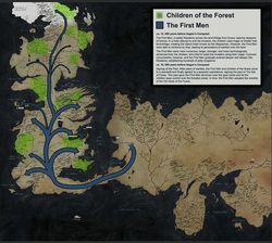 For those Carto-nerds/Game of Thrones fans out there. the entire history of Westeros told through maps:
http://imgur.com/a/GRIkN#0 |
Categories
All
Archives
March 2024
|
 RSS Feed