 Although this is not a new course, it hasn't been offered in a number of years at PCC - Here are the details:
GEOG 250: Geography of Africa (CRN 16198) Where: Portland Community college, Sylvania campus When: Winter 2014, T/TH from 9:00 AM to 10:50 AM Course Description: Africa is the second largest and second most populated continent in the World. It has rich history, vivid cultures and societies. It has greatly contributed to world civilization by providing the world's most valuable minerals and natural resources, as well as human resources to contribute in the economic development of the modern Europe and North America. Yet, Africa has been misunderstood and most misrepresented continent in the world. It has long been shown in the media as a place of crisis. It is a region of the world often known for civil wars, AIDS/HIV, diseases, corruption, starvation, and environmental destruction. Africa offers us to study the complex relationship between environment and society. This course is an introduction to the geography of Africa. In this course, we will study the current physical and human conditions in Africa and our area of focus will be mostly Africa south of the Sahara. We will examine the problems facing contemporary African societies. We will explore why Africa has became a place of such deep contrasts between crisis and hope. The course will help you to search below the stereotypes of One Africa without hope, but it will deepen your understanding of its multi-faceted continent. 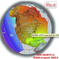 Check out this great blog post in American Scientific that discusses data integrity, datums, projections, data relevancy (as its related to time).
http://blogs.scientificamerican.com/critical-opalescence/2013/11/11/what-happens-to-google-maps-when-tectonic-plates-move/?WT.mc_id=SA_emailfriend  The Census Bureau offers both web-based and in-person courses to help you access and use Census Bureau statistics. These free courses can teach you how to use our databases and mapping tools, find local and national demographic information for a variety of uses including grant proposals, economic data statistics for business plans, research papers, etc. Check out our eTutorials and course descriptions.
Go here for more info: http://www.census.gov/mso/www/training/  GIS professionals, students, enthusiasts, supporters, and friends:
Please join your comrades and friends for the 2nd Annual GIS Day celebration on November 20, 2013! We will be enjoying refreshments, conversation, a presentation, and Geo-trivia at Laurelwood (5115 NE Sandy Blvd) starting at 5:30pm in the room upstairs. 5:30pm - Refreshments & socialize 6:30pm - Keynote speech by Analisa Fenix, GIS Manager & Chief Cartographer at Ecotrust 7:30pm - Geo-trivia! with prizes provided by DOGAMI, Metro & ESRI This event is sponsored by PCC, OR-URISA Young Professionals, and the PSU ASPRS Student Chapter. Refreshments will be provided. Event flier is here. Please pass along to any interested parties or individuals!  GIS Analyst
Portland, Oregon General Purpose Performs functions including GIS analysis, spatial data acquisition, quality control, modeling, integration; spatial database development; development of processes and solutions; support of other business systems utilizing spatial data; cartographic production; calculation and reporting of spatial statistics; and tracking of work activities. Develops and maintains operational and procedural documentation and adheres to departmental standards. Responsibilities of this position include the following:
Preference may be given to candidates who meet the above and have the following:
To apply, please visit our website at www.pacificorp.com and click on the Careers tab. Reference job #130954. At PacifiCorp, we encourage everyone to work together. We embrace diversity and value the distinct and different perspectives our employees bring to the table. We consistently strive to weave diversity into the fabric of everything we do. PacifiCorp is an equal opportunity employer that values diversity in the workplace.  CartoDB is hosting a free, online class on December 3rd from 2:00 - 3:30pm MST.
http://cartodb.com/academy CartoDB is a powerful, affordable platform for interactive web maps. I would suggest that anyone interested in expanding their skillsets or just starting with interactive maps check out the class.  The Geography department at Expedia, Inc. has a temporary Geographer position opened, and it would be great if you could send this out to UW’s Geo mailing list. Below is the job description. Interested candidates can email their resumes to Janet Wong at yw...@expedia.com.
Complete Description: The Geography team is responsible the management of all geographic and mapping data across the Expedia, hotels.com, and Venere brands. The geographic data that ensures a consistent travel-oriented presentation of destinations in all destination search formats on the sites includes global geographic hierarchy from continents to neighborhoods, locations of hotels, associations of airports and train stations to destinations, landmarks, and alternate names for destinations. Position Overview: The geography contractor is responsible for creating and maintaining geographic data required for a subset of lines of business, such as hotels, for Expedia points of sale. This work includes obtaining latitude and longitude data, database entry and understanding geographic hierarchy reporting infrastructures, etc. The ideal candidate will have worldwide geographic knowledge. The individual will have familiarity with mapping products such as MapPoint, Google Earth, and other web-based mapping tools. Excellent organizational skills and the ability to prioritize multiple projects while addressing and following up issues in a timely fashion are required. The qualified geographer must have the ability to explain geographic complexities to uninformed users which may involve language and cultural differences. Note: This is NOT a GIS Position Responsibilities: Completing individual tasks and communicating status on these tasks to impacted parties including point of sale and market management representatives. Applying geography team processes in order to complete his or her tasks within timelines. Provide support for geographers regarding large functional areas such as regional (Americas, Europe, and Asia) ownership of geographic data. Requirements: -2+ years demonstrated administrative support -Highly accurate data entry skills -Proficiency with MS Excel, MS Word and online tools -Extremely detail oriented -Experience with online mapping products, such as MapPoint, MapQuest, Google Earth -Knowledge of at least one foreign language is beneficial. -Travel Industry experience and database knowledge are a plus -Degree in Geography or related field preferred  Looking to hiring a GPS data collector for a Eugene, Oregon project. It starts immediately and lasts through February with possibly extensions to the current project and a permanent position later this year ( a strong chance). The pay is $15/hr with normally 32 hours of work a week but that is variable + or - 8 hours a week. Days off would be Tuesday, Thursday, and Friday but again this is variable. This is a field job and with a lot of autonomy so the candidate must be flexible and able to work on their own. The candidate has to arrange lodging in the Springfield/Eugene area.
If interested contact Philip O'Leary at oleary_philip@yahoo.com for more information.  Dare we say... mappy hour? | Comp Plan Map App and the Regional Equity Atlas
Thursday, November 14, 2013 5:30 PM to 7:00 PM Lucky Lab | 915 Southeast Hawthorne Boulevard, Portland, OR (map) You like maps. You like Portland. You like beer. You like meetups. Come to Lucky Lab for a discussion of two new web-based mapping applications dedicated to regional equity and planning issues: Portland's Comprehensive Plan Map App http://www.portlandbps.com/gis/cpmapp/ Coalition for a Livable Future's Regional Equity Atlas 2.0 http://gis.oregonmetro.gov/equityAtlas/ Have a drink with GIS staff and developers from the City of Portland's Bureau of Planning and Sustainability, the Coalition for a Livable Future, and Metro, who will discuss how the apps were built and how you can use them to learn about planning and equity issues facing Portland and the Metro region. Focus will be on the development frameworks, APIs, and server-side stuff used to build these mapping and public engagement tools. We'll also touch on what works, what does not, what we'd do differently if we could start from scratch, and what we'd love to do if we could figure out how (that's where you come in). Be fun! If not, there's the beer. No sign-up required... just show up. Room holds 60.  Position - General Summary
West Multnomah Soil & Water Conservation District is hiring one limited-duration, at will, non-exempt, part- time Field Intern for the winter 2014 (approximately January –April). This internship is designed to provide experience in the areas of mapping, GIS, water quality, invasive species, habitat restoration, forestry and agricultural land uses. Work will primarily be in the office however there will be times when this person will be asked to assist staff in an outdoor setting. Office work will involve mapping with ArcGIS, technical writing, database management, project management and office communication. Field work will include data collection, site inventories, and assisting with plant surveys. Candidates should have a strong knowledge understanding of GIS with the ability to create shapefiles, manipulate data and produce maps. The person filling the position should also possess knowledge/experience in the following areas:
Report & article writing Project management Data entry and management And have the ability to use personal vehicle and clean driving record Qualified candidates must be able to work independently and as a part of a team; and be able to communicate with project leaders. Download full job description and application details. |
Categories
All
Archives
March 2024
|
 RSS Feed