|
See the recent announcement from Bing/Microsoft about creating 125 million buildings' footprint data and releasing it as open data.
https://blogs.bing.com/maps/2018-06/microsoft-releases-125-million-building-footprints-in-the-us-as-open-data/ The Oregon Department of Geology and Mineral Industries has launched the Lidar Data Viewer interactive map, which offers additional data and new features that make exploring and downloading lidar easier than ever before.
Visit the viewer: https://gis.dogami.oregon.gov/lidarviewer/ Since the Oregon Lidar Consortium (OLC) was formed in 2007, DOGAMI has collaborated on collection of lidar data with more than 80 partners. The viewer offers OLC data for free download, and now includes data from 18 recent OLC projects. The newly available data includes:
For more information about the Lidar Data Viewer or the Oregon Lidar Consortium, contact: Jake Edwards Oregon Lidar Consortium Coordinator jacob.edwards@oregon.gov 971-673-1557 On April 1, 2016, NASA's Land Processes Distributed Active Archive Center (LP DAAC) began distributing ASTER Level 1 Precision Terrain Corrected Registered At-Sensor Radiance (AST_L1T) data products over the entire globe at no charge. Global distribution of these data at no charge is a result of a policy change made by NASA and Japan.
The AST_L1T product provides a quick turn-around of consistent GIS-ready data as a multi-file product, which includes a HDF-EOS data file, full-resolution composite images (FRI) as GeoTIFFs for tasked telescopes (e.g., VNIR/SWIR and TIR ), and associated metadata files. In addition, each AST_L1T granule contains related products including low-resolution browse and, when applicable, a Quality Assurance (QA) browse and QA text report. More than 2.95 million scenes of archived data are now available for direct download through the LP DAAC Data Pool and for search and download through NASA‘s Earthdata Search Client and also through USGS‘ GloVis , and USGS‘ EarthExplorer . New scenes will be added as they are acquired and archived. ASTER is a partnership between NASA, Japan‘s Ministry of Economy, Trade and Industry (METI), the National Institute of Advanced Industrial Science and Technology (AIST) in Japan, and Japan Space Systems (J-spacesystems ). Visit the LP DAAC ASTER Policy Change Page to learn more about ASTER. Subscribe to the LP DAAC listservfor future announcements. 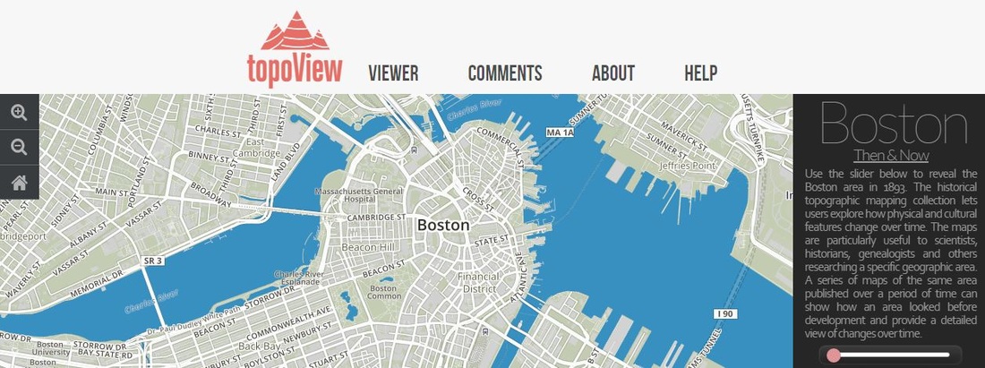 USGS just made it so much easier to access current and old topographic maps - this viewer allows you to see any topographic map dating back to the 1880's! There's over 178,000 of them and they are free and downloadable.
Check it out: http://ngmdb.usgs.gov/maps/Topoview/ 
Dr. Tosha Comendant, Senior Scientist at Conservation Biology Institute, will give an introductory tour to demonstrate multiple ways to explore and create content in Data Basin. Data Basin is an online mapping and analysis platform that supports learning, research, and sustainable environmental stewardship. The tour will include examples of keyword & geographic search functions, mapping, and collaborative tools. A 30 minute presentation will be followed by 15 minutes of informal questions and discussion. Questions always welcome to: databasin@consbio.org
Title: Navigating the Data Basin Platform: A Guided Tour Date: Thursday, January 15, 2015 Time: 10:00 AM - 10:45 AM PACIFIC TIME Space is limited. Reserve your Webinar seat now at: https://www3.gotomeeting.com/register/191385110 After registering you will receive a confirmation email containing information about joining the Webinar. View discussion online: scgis.org/discussion/id/641 LOS ALAMOS, N.M. – Regulators, stakeholders, scientists and the greater public will have access to remediation and other environmental data records associated with EM’s legacy nuclear cleanup program in near real time on a new website portal. Conversion to this cloud-based system achieved a substantial reduction in operating and maintenance costs, with changes and process improvements resulting in an estimated total cost savings of more than $15 million through 2015.
Previously contained in a dozen independent databases, the integrated records of Los Alamos National Laboratory (LANL) — part of DOE’s network of national laboratories — are now stored in one location, the website Intellus. The system contains 14 million records, including more than 28,000 locations and about 300,000 samples. The data span a wide range of media including air, soil, sediment, biota, and water, and it includes various analytes and time periods.  The U.S. Environmental Protection Agency (EPA) has released the third edition of a report, ‘Climate Change Indicators in the United States.’ The report presents observed data on key measures of our environment, including U.S. and global temperature and precipitation, ocean heat and ocean acidity, sea level, length of growing season, and many others. With 30 indicators that include over 80 maps and graphs showing long-term trends, the report demonstrates that climate change is already affecting our environment and our society.
The third edition of the Indicators report adds additional years of data and four new indicators: Lyme disease, heating and cooling degree days, wildfires, and water level and temperature in the Great Lakes. In addition, the report adds four new features that connect observed data records to local communities and areas of interest, including cherry blossom bloom dates in Washington D.C., timing of ice breakup in two Alaskan rivers, temperature and drought in the Southwest, and land loss along the mid-Atlantic coast. EPA compiles decades of observed data in cooperation with a range of federal government agencies, nongovernmental organizations, universities, and other institutions. The Indicators report focuses on long-term trends for key measures of our environment for which high-quality data exist. Each indicator and the report itself were peer-reviewed by independent experts, and extensive technical documentation accompanies the report. To order a FREE copy of the report, send a request with your mailing address included to climateindicators@epa.gov To find more information about the Climate Change Indicators report, or to download a PDF copy, visit http://www.epa.gov/climatechange/indicators.html  Check out the article in the Oregonian that announces DOGAMI's release of 46,000 landslides to the statewide database.
http://www.oregonlive.com/pacific-northwest-news/index.ssf/2014/04/oregon_adds_46000_landslide_lo.html  To help communities and citizens plan for the risks of coastal flooding and other climate-change-related impacts, the Department of Homeland Security, the Department of Defense, the National Geospatial-Intelligence Agency, and the U.S. Geological Survey are releasing today a collection of non-sensitive datasets containing mapping information on hundreds of thousands of the Nation’s infrastructure units and geographical features, including bridges, roads, railroad tunnels, canals, and river gauges.
These data are being made available via user-friendly mapping services on Geoplatform.gov and Climate.data.gov. |
Categories
All
Archives
March 2024
|
 RSS Feed