CHRISTINA FRIEDLE
  • Home
  • About Me
  • Courses
  • GIS Club
    • About Us
    • Don't be a Dangle!
    • Event Calendar
  • Resources
    • Data
    • Tools
    • Blogs
    • ArcGIS Install
  • Blog
  • Aventuras Colombianas

5/21/2018

Layer to KML(Z)

0 Comments

Read Now
 
Written by Thyra Bishop

I spent 28 years as a member of the United States Air Force, as a weather officer.
I loved giving weather briefings.  However, the word, “briefing,” means to be short and to the point.  I first found out about Google Earth when I was stationed in Afghanistan.  It was such an exciting platform, and I loved being able to use Google Earth to look at my home in Portland, Oregon.  I’d also look at different areas in the Pacific Northwest and dream of home.  Back then, in 2009, I had a lot of hope that I could use the platform to create weather briefings that were more to the point and interactive, and just plain fun to view. 
But of course, getting the data onto Google Earth, and the, “Comm Nazis,” (our term for the communications personnel that would limit our accesses to fun online programs) wouldn’t let us use Google Earth for our presentations anyway.

Now I know how I can put data into a .lyr file then convert the .lyr file to .kmz to show on Google Earth.

Follow along if you too want to put data onto Google Earth.
  • Open ArcMAP
  • Pull up a map you have worked on with different layers.
  • Layer can be RASTER or FEATURE layer.
  • Using my Fall 2017 GEO 265 Project Here is an image of my county and bridge maps.
Picture
  • I made sure I had layers for:
Oregon Coastal Counties
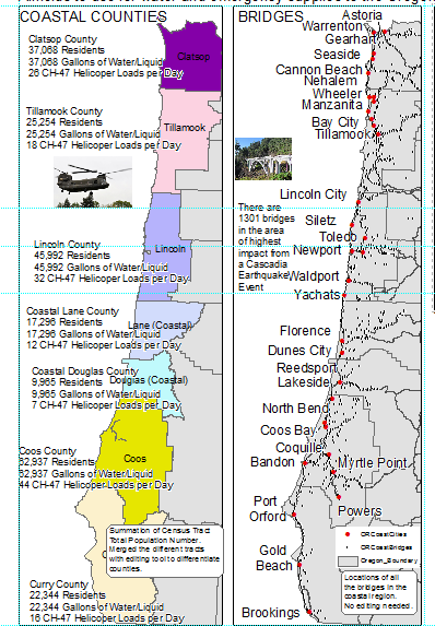
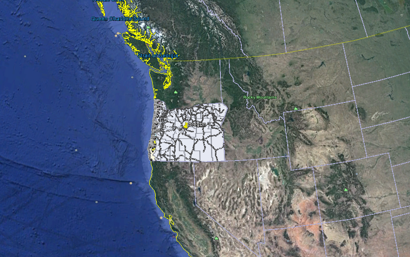
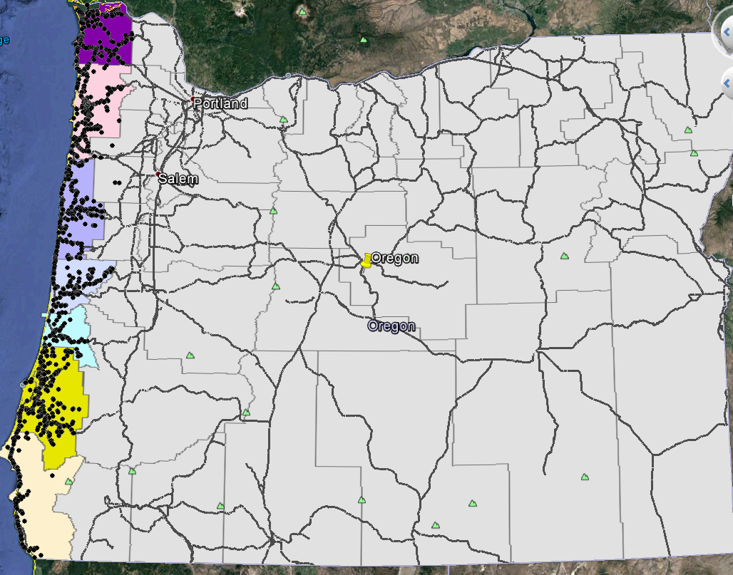
Oregon Boundary
Oregon Coast Cities
Oregon Coast Bridges
Oregon Coast Highways
 
  • I saved each layer in a file called Google Earth, so I can easily find them to use the conversion tool.
  • ArcToolbox > Conversion Tools > To KML > Layer to KML
Picture
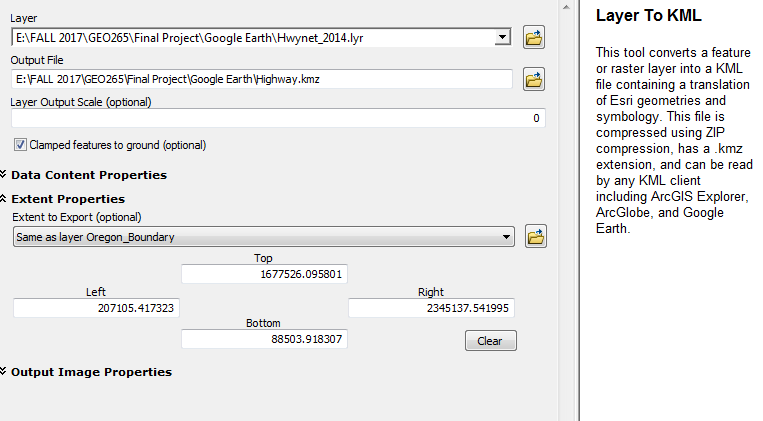
You want your input layer, make sure you output to a file where you can find it again.  I recommend setting the extent properties.  I set my extent to the same layer as the Oregon_Boundary
 
Now you can show it in Google Earth:
  • File > Import > find the file you just made that ends with .kmz
Now you can view the data on Google Earth.
Picture
Picture
Picture
Direct from ArcToolbox:
Layer To KML (Conversion)

Summary
 This tool converts a feature or raster layer into a KML file containing a translation of Esri geometries and symbology. This file is compressed using ZIP compression, has a .kmz extension, and can be read by any KML client including ArcGIS Explorer, ArcGlobe, and Google Earth.

Usage
You can control the appearance of KML in two ways:
  • If layer properties such as the HTML PopUp setting, display expression, and the alias for KMLSnippet are used, they will be used in the creation of the KML.
  • When the layer properties are not set and the feature class contains certain attributes (fields), the field properties will be used in creating the KML. Layers that were originally created using the KML To Layer tool have attributes that define how KML will be created.

A few other pointers
  • You can reduce the size of the output KMZ document if your layer has scale-dependent display properties and you choose an appropriate map output scale.
  • All KML and KMZ files are created in the WGS84 coordinate system. You need to be sure your layers will properly project if they aren't already in WGS84. You can use the Project tool to reproject your data prior to KML conversion if your projection requires a transformation.
  • To output a single raster image draped over topography, use the Return single composite image option.
  • Input features with attachments will be included in the output .kmz file. Be aware of the following conditions for attachments inside .kmz files.
  • Attachments can dramatically increase the output file size.
  • When consuming the KML file in a KML client, attachments are available from the KML pop-up.
  • Attachments can be excluded by disabling the Maintain Attachments environment setting prior to running the tool.
  • Not all KML clients support displaying attachments equally. Some KML client applications have better support for attachments like images and PDFs.

Share

0 Comments


Leave a Reply.

Details

    Author

    Blog posts are written by students in the Interactive Map Design course at Portland Community College.

    Archives

    June 2018
    May 2018
    April 2018
    June 2017
    May 2017
    April 2017
    June 2016
    May 2016
    April 2016

    Categories

    All
    GIS
    QGIS

    RSS Feed

Contact ME

  • Home
  • About Me
  • Courses
  • GIS Club
    • About Us
    • Don't be a Dangle!
    • Event Calendar
  • Resources
    • Data
    • Tools
    • Blogs
    • ArcGIS Install
  • Blog
  • Aventuras Colombianas