|
Written by Parker Hill
When I first learned that OpenStreetMap (OSM) existed, I immediately thought of Wikipedia. An online interactive map that anyone can edit or add data to? What an incredible concept! I read several years ago that Wikipedia has become by far the largest encyclopedia that has ever existed—the English version alone contains roughly sixty times as many words as the second largest English-language encyclopedia—and due to its dynamic, “alive”, nature with over thirty million registered contributors, it has become very, very accurate, though still not accepted as a reliable resource to cite in an academic context (it will be interesting to see how this changes over time). What is intriguing about Wikipedia is that the more it grows and the more people that contribute to, edit, and maintain it, the more apparent it is that our species as a whole wants it to work correctly—meaning that we, as users, want its contents to be unbiased, factual, accurate, and up-to-date (of course we do). Vandalism of Wikipedia is easily detected when it occurs, both by human contributors and vandalbots, and inaccurate information recorded innocently will be corrected as the article evolves over time. The sheer vastness of Wikipedia ensures that each contributor’s input is infinitesimal relative to the total volume of content—it’s nearly impossible to damage it. Wikipedia may be the greatest encyclopedia humans have yet created. Anyway, back to OpenStreetMap. Before I ever even typed in the URL for OSM, I knew that the more people actively contributing to it, whether by creating, correcting, or editing features, the more useful, accurate, and up-to-date it should become. I’m glad to report that there are presently over three million registered users with OSM accounts and this number is growing. 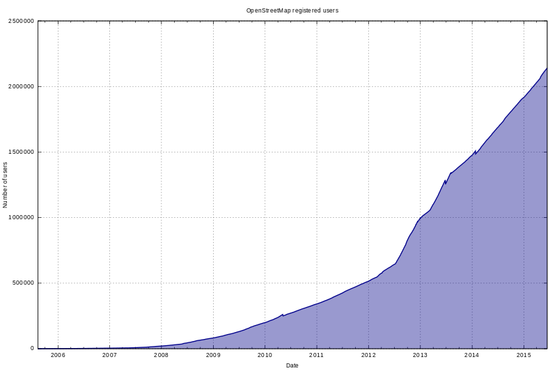
The Evolution of OpenStreetMap
OpenStreetMap was created in 2004 by British entrepreneur Steve Coast in order to build a more detailed online map of the UK. By 2007, interest had grown enough to warrant an international conference called State of the Map, which was sponsored by Google and other companies and has since been a yearly event. That same year the U.S. Census Bureau’s TIGER/Line road data were imported, a major milestone since, first of all, previous road data were mostly created from users’ own recorded GPS tracks (very time-consuming) and, secondly, there now existed a road basemap covering all of the United States—until this point, most data in OSM was being added for Europe. Another important milestone occurred in 2010, when Microsoft’s Bing Maps granted OSM contributors the right to trace features using Bing aerial imagery (Yahoo!’s aerial imagery had previously been used for the same purpose but was inferior). I should add here that one of OSM’s principle rules is that content cannot be copied from other maps unless they are in the public domain. Having quality aerial imagery to trace is a huge deal. In 2012, Google started charging fees for websites that incorporate Google Maps within their own content, prompting a handful of notable companies and organizations, including Craigslist and Foursquare, to drop Google and switch to OSM (you may remember 2012 being the year Apple launched Apple Maps, which uses OSM in part). Today more and more companies, organizations, and websites are taking advantage of OSM not only for its free and open geospatial data but also for its increasing detail, accuracy and up-to-dateness, not to mention its real-time editability. The Future’s Best Interactive Map? If you haven’t looked at OpenStreetMap, scroll up to the top of this post where you will find it embedded. Take a moment to zoom in and out, pan around and examine the details in Portland. Due to the interest, care, and dedication of the community of contributors, we have a much superior interactive map compared to the ubiquitous Google’s (though areas that are sparsely populated tend to be sparsely mapped in OSM). I think that we will become more and more familiar with OpenStreetMap as time moves forward. Wikipedia has shown that an open and community-created and maintained encyclopedia can only get better and better as it grows. Humans have shown that access to vast, accurate, and up-to-date encyclopedic knowledge for everyone is an important priority that we are willing to work together on. Because we live in a spatial context and need to know where things are and how to intelligently move around, I hope that access to this “living” and dynamic community-generated map proves to be a priority as well, possibly resulting in the greatest interactive reference map yet.
6 Comments
Ian Amitin
5/9/2017 03:38:06 pm
After signing up and making my first edits, I am officially addicted. I was surprised by the sense of responsibility I felt when making edits in Portland. I can see the potential for growth in detail as you described!
Adele Rife
5/16/2017 12:33:35 pm
I've never thought of it as the Wikipedia of maps! I like that, it's so true. I'm curious to see how it changes as the years go on. For example, Portland is very mapped out but less populated places still have a lot of blank areas. Also, Wikipedia is very straightforward and mainstream, while I feel like not everyone thinks of contributing to maps.
Haley Jones
5/18/2017 02:48:37 pm
This was very interesting Parker! I haven't spent any time yet looking into OSM, so this was very informational. It sounds like we (people who want to make interactive maps) should/could be using an OSM api in place of a Google Maps api. I suppose that depends on how developed our area of interest is on OSM. I like the idea of supporting and being part of an open community of shared knowledge that we can all contribute to and feel good about; as opposed to being subjects to the data overlords who want to profit from tracking our every movement. Also, it's free, yay!
Baxter
5/25/2017 08:56:18 am
Very interesting, Parker! I am curious about OpenStreetMap's policy that content cannot be copied from other maps unless they are in the public domain. If somebody were making edits to a map, who is to say where they got their data from, or that they weren't just looking at google maps in another window? I wonder how they enforce this.
eddie
5/28/2017 02:13:38 pm
Google is both the world's largest mapping platform and advertising platform, so it's no shock that their content is ad driven. We have to remember this, Google is a publicly traded company and profit is their bottom line. The information is there, and their tools are great, but there's always going to be profit motivation.
Parker Hill
5/31/2017 03:18:02 pm
Baxter, Leave a Reply. |
AuthorBlog posts are written by students in the Interactive Map Design course at Portland Community College. Archives
June 2018
Categories |
 RSS Feed