|
Written by Natalie Divine When I signed up for my first ArcGIS account I guess I forgot to uncheck the “add me to your mailing list” box because I began receiving ArcNews a few months ago. The first thing that I noticed on the front page of the Winter2018 issue was an article titled, “Learn to Design Beautiful Maps – Take ESRI’s Newest Massive Open Online Course: Cartography.” The headline reeled me in. I’m here to tell you, I highly recommend taking a “MOOC” (Massive Open Online Course) from ESRI. Here’s why:
There is a little bit of set up required – you have to download the lessons and then create a new username and then download ArcPro and then get your ArcPro login – but after that it is super user-friendly. No software is required, just a computer with internet. Some of my favorites parts so far are segments of the videos called “Cartofails” about all of the cartographic no-no’s (naming your legend “Legend”), and also “Tools of the trade” where they bring out old handheld cartographic tools like scribers and explain how mapmakers used them. MOOCs are on the rise in general and aimed at being free and open to everyone. I have also read about a some that are free to take and then for a fee (usually around $50-$100) you can upgrade and receive a certificate. These are offered from places like Future Learn, Coursera, Khan Academy, and edX, to name a few. Future Learn offers a MOOC called “Maps and the Geospatial Revolution” developed by Penn State, and edX has one called “Introduction to Urban Geo-Informatics” developed by Hong Kong Polytechnic University. If any of this has piqued your interest, check out this schedule of ESRI’s fall offerings: 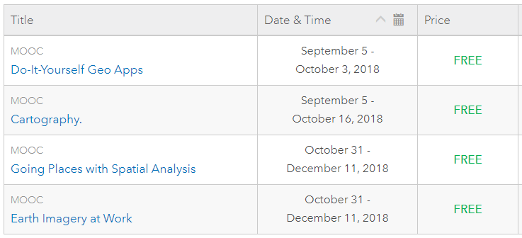 I for one will be taking Do-It-Yourself Geo Apps to continue building on web mapping skills I’ve gained in GEO244. Here is the course description,
“Anyone can build apps on the ArcGIS Platform. You don't have to be a software developer to build valuable geo-enabled apps that make your communities smarter and businesses more successful. This course will show you how to combine location and narrative in one application to better communicate and broadcast your story, create custom web applications that solve problems in your community, and build powerful native applications for iOS and Android devices without touching a piece of code. If you are a developer, you'll be interested in Esri's APIs, SDKs, and the buzzing GeoDev community.” See you there!
3 Comments
Kaitlyn
6/4/2018 03:34:20 pm
This is so cool! I really like that there is a ton of free information that is available to keep building on the skills that we're learning! I'll absolutely have to check out some of these lessons!
Thyra
6/4/2018 05:17:42 pm
Thanks for the MOOC endorsement. I was hesitant to sign up, but your blog changed my mind.
bob nicholas
6/12/2018 02:19:36 pm
I must have left that same box unchecked because I keep getting those same e mails. My youngest son has done a few of them and recommends it. I think I will try some of them in order to not lose this new knowledge I have been working so hard on. Thanks for the point in the right direction. Leave a Reply. |
AuthorBlog posts are written by students in the Interactive Map Design course at Portland Community College. Archives
June 2018
Categories |
 RSS Feed