|
Written by Robert Mannering Inevitably, any history of an Empire has to fundamentally contain a history of the people within that Empire and how the subjects were managed. Increasingly, the history of cartography as a field has developed to explain the identity of Empires; and the study of systems of management and control has led to a better understanding of how early modern societies worked and what life was like within them. At http://downsurvey.tcd.ie, Trinity College in Ireland has georeferenced an incredible amount of data from 17th Century post-Tudor England and displayed the results in an incredible series of webmaps that bring to life a fascinating GIS project from the 1650s. But before getting into that, it’s worth considering what led to the historic survey in the first place over a couple of paragraphs of “pub history”. As is the case with most islands, the earliest patterns of urban development in Irish history can be observed along the coastline. While the traditional Gaelic clans and tribes kept to forested inland regions, Ireland’s Viking cities played host to an ever changing cast of invaders and settlers beginning in the 8th Century. This culminated in the Norman conquest of England in 1066 which soon led to a permanent Anglo-Norman settlement in Ireland. Generations of trade, inter-marriage and cross cultural assimilation between the ‘Old Irish’ Gaels and the ‘New Irish’ Normans gradually created an Irish-Norman identity unique to that of their distant cousins in England. Land hereditary practices, clan-based political systems and religious ceremonial procedures created a new Norman identity. However, crucially, the character of this identity remained loyal to an English crown that content to allow the New Irish to administrate the island in their name. Although this uneasy set-up waxed and waned over time, it nonetheless persisted until the English Reformation. The establishment of a Protestant Church of England by Henry VIII triggered a century of warfare over the English throne and the religious identity of the British Isles. Eventually, following the collapse of the last of Irish military opposition to English rule in the mid 1600s, the remaining Norman lords fled to France and the securement of the English Crown in Ireland was completed in 1652 with the passage of The Act for the Settlement of Ireland by British parliament.. The vacancy left from Norman landowners who had left, combined with the urgent need for loyal landowners to take their place, led to a systematic expulsion of ‘Old Irish’ and ‘New Irish’ from their land and pushed their presence to the barren reaches on the west of the island. In their place, land was gifted out to loyal English soldiers and noblemen. The complete resettlement of the island in turn brought with it a completely new system of management leading to the British Empire conducting possibly the first GIS project on a national scale to map and record the scale of land ownership change that had taken place over the previous decades. This soon became a trend, and into the modern era, Ireland became the subject of some of the most rigorous cartographic practices in the world at the behest of an Empire desperate to control and manage some of its most difficult possessions. Today, Trinity College’s webmaps detail not only the scope and depth of Irish Ordinance Surveys across the centuries (including a groundbreaking 20 year survey in 1824 that produced maps for the whole island at a 6 inch scale of resolution), but also create an interactive archive that shows on a modern web map of Ireland where historic land parcels were located and tied to the details of the title holders who owned them. There are two main components to the website. The first is a digital series of all of the maps originally created for the crown which can be panned and zoomed across. 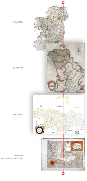 The above graphic shows the 4 levels of scale that the Down Survey created in 1641. Starting with an overall map of the Island, surveyors then made sub division maps for each county, baronies within each county and parishes within each barony. The second aspect of the site is a webmap that has all of the archived Down Survey information geo referenced to open streetmaps. This map can be queried for entries in the original survey and it will deliver the results in their modern location. 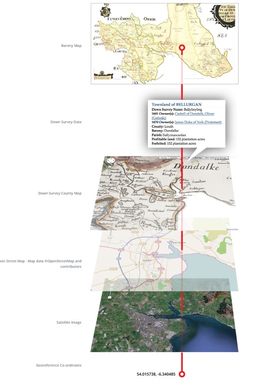 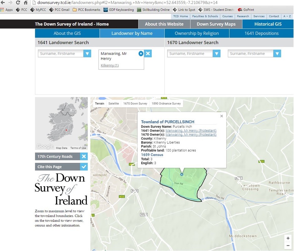 He’s named like my name! A couple of other points of analysis are on the site too, such as a 17th century crime map based on archived court depositions as well as a comparison of landownership between catholics and protestants, pre and post Oliver Cromwell: 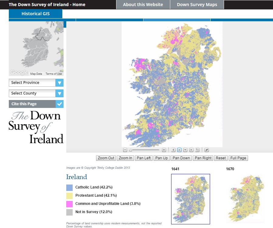 Spatial evidence of Oliver Cromwell not being a celebrated figure in Ireland.
So, there it is. Historical cartography. Pretty nifty. There’s a huge archive of geo-referenced historical maps from across the world at http://www.davidrumsey.com/. Also, http://www.washmapsociety.org/ is a historic cartographic society that publishes a quarterly journal a lot of historical aspects of maps and how they were built and used across the ages. If nothing else, it’s probably a good topic of conversation during a job interview. Hope you guys are into it!
4 Comments
Mike McGiboney
5/31/2016 01:34:31 pm
Fascinating stuff, especially for a history buff and for someone who has visited and explored the region. I wonder if anything has been done like this for England, Scotland and Wales? It'd be interesting to see if the Domesday book could be plotted and done like this.
Robert Mannering
6/2/2016 02:05:49 pm
Oh wow sounds like your kinsmen got in on the Ulster Plantations. Have you checked the down survey records for variations on your last name?
Mike Holscher
6/3/2016 11:37:33 am
Thanks for the history lesson. We get a lot of American history up through WWII pre-college. As a biologist, there was not a lot of time for collegiate endeavors into history. I am trying to catch up over my lifetime. The sure level of geo-referencing that has occurred to create this webpage is outstanding. Not sure I want to be the one to do it. Guess that's was interns and new hires are for. Oh wait, maybe this will be my job someday. 10/4/2022 08:53:33 pm
I'm always fascinated by history. Land hereditary practices, clan-based political systems, and religious ceremonial procedures created a new Norman identity, which is new to me. However, the essence of this identity remained loyal to an English crown content to let the New Irish administer the island in their name. Leave a Reply. |
AuthorBlog posts are written by students in the Interactive Map Design course at Portland Community College. Archives
June 2018
Categories |
 RSS Feed