CHRISTINA FRIEDLE
  • Home
  • About Me
  • Portfolio
  • Resume | CV
  • Contact
  • Blog

geospatial: jobs| internships | events | news | more

Survey Crew Chief w/ ODOT

2/28/2024

 
https://oregon.wd5.myworkdayjobs.com/SOR_External_Career_Site/job/Portland--ODOT--Region-1-Headquarters/Survey-Crew-Chief_REQ-150135

Job Description:
Civil Engineering Specialist 1 – Survey Crew Chief
Oregon Department of Transportation
Delivery & Operations Division – Region 1
Project Delivery
Portland


The role: 
Is getting the map right important to you?  Is providing guidance and development to a team part of your skill set?  If being a part of an organization that builds, operates and maintains multi-modal transportation interests you, then consider becoming a survey crew chief with ODOT. We currently have a position open in our Region 1 survey unit. You will perform and process field surveys for the development, design and monumentation of ODOT facilities and projects. This involves guiding a survey field team and making personal contact with the public and other governmental agencies.  You will also be an important member of the survey unit which provides goals, direction and strategies in a shared decision-making environment.  Interested? Apply today!

We encourage people from all backgrounds to apply for our positions. We hope you’ll join us on our path to increasing diversity, equity, inclusion and belonging through our values, commitments, strategies and actions.

Before applying, visit our applicant information website to learn more about our process. If you are a current State of Oregon employee, you must apply through your employee Workday profile.

A day in the life:
  • Plan and coordinate the work activities of a survey crew consisting of one to four people.
  • Operate advanced survey equipment and software.
  • Establish horizontal and vertical control for proposed and existing facilities.
  • Locate and mark government corners, property corners, cultural features, and terrain data.
  • Obtain terrain data necessary to produce three dimensional topographic and cadastral maps GNSS, Total Stations, and Stationary Lidar scanners.
  • Draft various maps and models from survey data.
  • Provide staking for transportation projects.
  • Establish and monument rights of way, construction centerlines and property boundaries.
  • Prepare accurate and detailed notes documenting found evidence and work performed; submit and review field notes and electronically collected data for processing.
  • Communicate survey information orally, digitally and in writing.
  • Train coworkers in the performance of duties.
  • Perform outdoor work 60% or more of the time in all weather conditions and subject to hazards including traffic and construction equipment daily.
  • Exposure to rough terrain, traffic, stinging insects, poisonous plants, surfaced pavements, and inclement weather. and lift equipment or loads up to 50 pounds.
  • Long hours and/or night shift work may occasionally be required.
  • To request a copy of the position description, which includes all duties and working conditions, please email [email protected].

What’s in it for you:
  • Work/life balance, 11 paid holidays a year, flexible work schedules, paid leave and so much more. Learn more about working at the Oregon Department of Transportation and the benefits we offer.
  • Competitive benefits packages which can be estimated using our compensation calculator.
  • Comprehensive and equitable base salary offer within the listed range based on your experience, skills and education. The salary range listed is the non-PERS participating rate. If you are already a participating PERS member or once you become PERS eligible, the salary range will increase by 6%. Please review the Classification and Compensation page for more details.
  • Public Service Loan Forgiveness opportunity!

Want to know about new job postings? Subscribe to receive weekly email notifications!

Minimum qualifications:
Four years of para-professional engineering or surveying experience. One year of this experience must have been working independently or as a senior member of a team or work group.

OR
An associate's degree in engineering technology or surveying from a recognized community college or technical school of engineering and two and one-half years of engineering or surveying experience. One year of this experience must have been working independently or as a senior member of a team or work group.

OR
A bachelor's degree in civil engineering, surveying, or transportation-related engineering and one year civil engineering or surveying experience.

OR
An equivalent combination of education and experience.

Special qualifications:
Driving is an essential function of this position. You must have a valid driver license and an acceptable driving record. We will conduct pre-employment driving records checks on our final candidate(s). Your license does not have to be issued in Oregon to be considered.

What we’d like to see:
If you have these attributes, let us know in your application materials! It's how we will choose whom to move forward! You do not need to have all these qualities to be eligible for this position. We may also use transferable skills, experience, education and alignment with ODOT values to help us decide who will move forward.
  • Experience coordinating survey field crew duties and making independent judgment on safety and work productivity.
  • Experience using robotic total stations, scanners, GNSS receivers, data controllers and associated software.
  • Experience safely locating and collecting field data such as land boundary and control monuments, utilities and topographic features.
  • Experience analyzing and processing field data for completeness and accuracy.
  • Experience using Computer Aided Drafting (CAD) software.
  • Experience working with stationary LiDAR scanner.

Geospatial Data Manager with The Nature Conservancy (VA)

2/28/2024

 
Closing date: 2024-03-29
Position: Geospatial Data Manager - The Nature Conservancy Global Science Team
Organization: The Nature Conservancy
Country: United States
State: Virginia
Contact: [email protected]
Contact Email: [email protected]


WHAT WE CAN ACHIEVE TOGETHER
The Geospatial Data Manager will work as part of a team within the Global Science Business Unit, providing a broad range of support to the Science Capacity team in coordination with the Spatial Conservation Science, Climate Science, Economics & Governance, and Human Dimensions teams. The Science Capacity program manages and implements science-related resources, including geospatial data and associated analytical methods, training, mentoring, peer-review services, communities of practice, knowledge management, a science survey, and science flagship events. Global Science partners with regions and global teams to provide critical science, technical expertise, and capacity building in support of achieving the organization's 2030 goals. The Science Capacity program is designed to meet the needs of TNC science and conservation staff with flexibility and inclusivity in mind, aligning with project and career goals to maximize participation. The program is aligned with the One Conservancy Science Plan. It empowers science staff to achieve their maximum potential, supporting scientists across TNC's global reach to achieve the organization's 2030 Goals for people and nature. This is a fully remote position. The position requires travel and working flexible hours as needed. The work environment involves only infrequent exposure to disagreeable elements and minor physical exertion and/or strain. The Geospatial Data Manager reports to the Global Director of Science Capacity. [Read more and apply](https://careers.nature.org/psp/tnccareers/APPLICANT/APPL/c/HRS_HRAM_FL.HRS_CG_SEARCH_FL.GBLPage=HRS_APP_JBPST_FL&Action=U&FOCUS=Applicant&SiteId=1&JobOpeningId=54730&PostingSeq=1) - this position is remote, open internationally, position open until filled.


WHO WE ARE 
The mission of The Nature Conservancy (TNC) is to conserve the lands and waters upon which all life depends. As a science-based organization, we develop innovative, on-the-ground solutions to the world’s toughest environmental challenges so that people and nature can thrive. Our work is guided by our values, which include a [commitment to diversity](https://www.nature.org/en-us/about-us/who-we-are/diversity-and-inclusion/) and respect for people, communities, and cultures. From a rewarding mission to career development and flexible schedules, there are many reasons to love life #insideTNC. Want to know more? Check out our [TNC Talent playlist on YouTube](https://www.youtube.com/playlist?list=PL-o5jtJniubZjnNuR4zpvmTBaiC-ZiSbJ)   to hear stories from staff or visit  [Glassdoor](https://www.glassdoor.co.in/Overview/Working-at-The-Nature-Conservancy-EI_IE14686.11,33.htm). One of TNC’s primary goals is to cultivate an inclusive work environment so that employees around the globe have a sense of belonging and feel that their unique contributions are valued. We know we’ll only achieve our mission by hiring and engaging a diverse staff that reflects the communities in which we work. Recognizing that people bring talent and skills that have been developed outside the scope of a job, we take a holistic approach to recruitment that considers life experience in addition to the professional requirements listed in our postings. Please apply – we’d love to hear from you. To quote a popular saying at TNC, “you’ll join for the mission, and you’ll stay for the people.”

Survey Technician w/ Cascade Timber Consulting

2/27/2024

 
Cascade Timber Consulting, Survey Department
Hourly Wage:  $21 - $25 depending on experience
Do you want to join our team? We are looking for candidates who enjoy outdoor adventures and who want to build their careers in land surveying!  This position offers field opportunities, project research, project planning, crew leadership, drafting, and more.  Our region covers the west slope and heights of the Cascade Mountains from Mollala, OR to Cottage Grove, OR.  Cascade Timber Consulting is a strong company with great benefits and advancement opportunities.  
Contact: Rick Jones, PLS (541)367-2111, [email protected]
or Rob Keene, PLS (541)818-8229, [email protected]
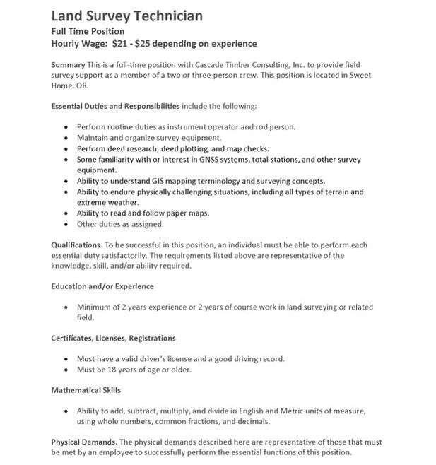
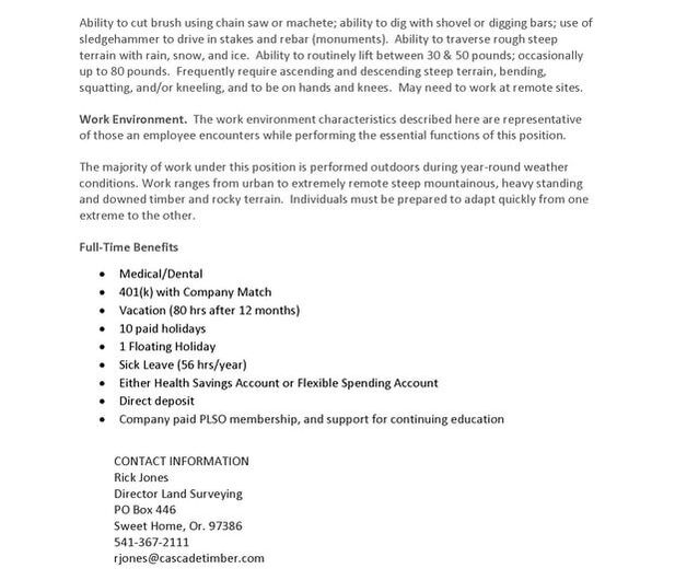
Picture
Picture

GIS Analyst w/ City of Corvallis (OR)

2/27/2024

 
Position Summary
The GIS Analyst or Senior GIS Analyst performs a variety of routine and complex skilled and technical work in the development of a Geographic Information System (GIS). Applies GIS technology to provide mapping, and GIS related technical and support. Performs research, analysis, design and creation of data and applications for use in the Geographic Information System.  Develops and maintains automated GIS systems and related information. In addition, the Senior Analyst coordinators and leads these areas.

​Essential Functions

GIS Analyst
  • Designs, creates, and maintains the citywide GIS databases, data sets, and mapping system.  Applies GIS technology to produce and perform advanced data entry and manipulation, produces documentation, performs spatial analysis and produces reports.
  • Researches, evaluates, recommends, acquires, installs and maintains GIS solutions and software.  Tests, de-bugs and maintains GIS applications.
  • Assists with analysis of short and long-range GIS planning.  Assists with contract administration for GIS work and related services.
  • Assists work groups and departments with the selection of appropriate GIS solutions.  Coordinates and directs implementation as appropriate.  Provides input and recommendations regarding hardware.
  • Oversees small-scale GIS projects.  Monitors project status, identifies and addresses potential barriers to meeting targets, assesses outcomes and recommends process improvements. 
  • Provides training, development, implementation and ongoing operational support for GIS and GIS users.
  • Develops and automates processes to update, maintain, and analyze databases and ensures spatial integrity.
  • Applies software such as, CAD, database, spreadsheet, word processing, communications, graphics and web publishing software to the production and delivery of GIS related products. 
  • Provides technical assistance to users.  Performs departmental-focused project management.   Meets with GIS users to define project requirements and set priority.
  • Participates on interdepartmental teams and committees for GIS projects.  Contributes to work group GIS software design projects.
  • Collects, inputs, edits, and verifies spatial data from a variety of internal and external data inputs. Integrates associated attribute data. Manipulates, models, and analyzes spatial data in the geographic information system.   Documents data entry and related procedures.
  • Operates printers, copiers and large-format plotters, and loads large rolls of paper into plotters.
  • Acts ethically and honestly; applies ethical standards of behavior to daily work activities and interactions.
  • Builds confidence in the City through own actions. 
  • Conforms with all safety rules and performs work is a safe manner.
  • Delivers excellent customer service to diverse audiences.  Maintains positive customer service demeanor and delivers service in a respectful and patient manner.
  • Maintains effective work relationships.
  • Arrives to work, meetings, and other work-related functions on time and maintains regular job attendance.
  • Complies will all Administrative Policies.  Performs work in accordance with Council Policies and Municipal Code sections applicable to position.

Senior GIS Analyst
  • Designs, creates, and maintains the citywide GIS databases, data sets, and mapping system.  Performs technical leadership, advice and support for all mapping and GIS functions.  Applies GIS technology to produce and perform advanced data entry and manipulation, produces documentation, performs spatial analysis and produces reports.  
  • Researches, evaluates, recommends, acquires, installs, and maintains GIS solutions and software.  Tests, de-bugs, and maintains GIS applications.
  • Leads the analysis of short and long-range GIS planning.  Administers contracts for GIS work and related services.
  • Leads work groups and departments with the selection of appropriate GIS solutions.  Coordinates and directs implementation as appropriate.  Provides input and recommendations regarding hardware.
  • Oversees large-scale GIS projects.  Monitors project status, identifies and addresses potential barriers to meeting targets, assesses outcomes and recommends process improvements.
  • Provides training, development, implementation and ongoing operational support for GIS and GIS users.
  • Develops and automates processes to update, maintain and analyze databases and ensures spatial integrity.
  • Applies software such as CAD, database, spreadsheet, word processing, communications, graphics and web publishing software to the production and delivery of GIS related products.
  • Provides technical assistance to users.  Performs departmental-focused project management.   Meets with GIS users to define project requirements and set priority.
  • Participates on interdepartmental and inter-agency teams and committees for GIS projects.  Contributes to work group GIS software design projects.
  • Operates printers, copiers and large-format plotters, and loads large rolls of paper into plotters.
  • Acts ethically and honestly; applies ethical standards of behavior to daily work activities and interactions.
  •  Builds confidence in the City through own actions.
  • Conforms with all safety rules and performs work is a safe manner.
  • Delivers excellent customer service to diverse audiences.  Maintains positive customer service demeanor and delivers service in a respectful and patient manner.
  • Maintains effective work relationships.
  • Arrives to work, meetings, and other work-related functions on time and maintains regular job attendance.
  • Complies with all Administrative Policies.  Performs work in accordance with Council Policies and Municipal Code sections applicable to position.

Qualifications and Skills

Education and Experience
  • High school diploma or equivalent.  Six years (nine years for Senior Analyst) professional experience in designing, supporting and implementing GIS applications.  
  • A post-secondary degree in GIS or closely related field may substitute for up to 4 years of experience. 
  • Municipal experience is desired.

Knowledge, Skills and Abilities - GIS Analyst
  • Good oral and written communication skills; ability to communicate technical information to a non-technical audience, ability to research, interpret and summarize data.
  • Ability to integrate, compare and correlated geographic information and related data into spatial data systems.
  • Ability to program in GIS, relational and spatial database, and web languages is desired.
  • Knowledge of GIS software, Computer Aided Drafting software, related third party GIS software applications, database management systems software and windows based operating systems.
  • Advanced skills in use of GIS related software in a production environment.
  • Knowledge of principles, concepts and tools of data management, data gathering, research and analytical abilities.  Knowledge and skill in administering relational databases.
  • Ability to research, interpret and summarize data.  Analyze complex mapping and GIS development and production strategies using current knowledge of computer applications and technology.
  • Ability to analyze complex mapping and GIS development and production strategies using current knowledge of computer applications and technology.
  • Ability to research industry trends and recommend new methods, equipment, or programs to better accomplish tasks.

Knowledge, Skills and Abilities - Senior GIS Analyst 
  • Strong leadership, interpersonal, organizational, and oral/written communication skills.  Ability to effectively communicate technical information to a non-technical audience.   Maintains effective working relationships.
  • Ability to integrate, compare, and correlate geographic information and related data into spatial data systems.
  • Ability to program in GIS, relational and spatial database, and web languages is desired.
  • Advanced knowledge of GIS software, Computer Aided Drafting software, related third party GIS software applications, database management systems software and windows based operating systems.
  • Advanced skills in use of GIS related software in a production environment. 
  • Knowledge of principles, concepts, and tools of data management, data gathering, and research and analytical abilities.  Knowledge and skill in administering relational databases.
  • Ability to research, interpret and summarize data.  Analyze complex mapping and GIS development and production strategies using current knowledge of computer applications and technology.   
  • Ability to apply evolving, advanced knowledge of complex computer systems, GIS and other system applications, systems operation and maintenance, aerial mapping programs and techniques, and system acquisitions.  
  • Knowledge of principles, concepts, and tools of data management, data gathering, research, and analytical abilities.
  • Strong project management, analytical, planning, and organizational skills.   Excellent time management skills; ability to manage multiple projects and to meet multiple deadlines.
  • Research industry trends and recommend new methods, equipment, or programs to better accomplish tasks.

Special Requirements
  • Travel among City worksites.
  • Demonstrable commitment to sustainability.
  • Demonstrable commitment to promoting and enhancing equity, diversity and inclusion.
  • The individual shall not pose a direct threat to the health or safety of the individual or others in the workplace.
  • Ability to pass a pre-employment background and/or criminal history check. 

HOW TO APPLY https://www.governmentjobs.com/careers/corvallisor/jobs/4397608/gis-analyst-or-senior-gis-analyst 

Multiple unpaid GIS internships with the VSFS program (Anywhere, VIRTUAL) - Closes Thur, Feb. 29

2/27/2024

 
Calling all U.S. college students!
 
Multiple virtual, unpaid, GIS internships with the Virtual Student Federal Service (VSFS) Program (Apps open until Thursday, February 29) – Anywhere, USA. See https://vsfs.state.gov/
 
Apply in February on USAJobs.gov. You may apply for up to five projects. All candidates will hear by May 2024 if they have been offered a position. See https://openopps.usajobs.gov/community/vsfs
 
Please find just a few examples of GIS projects below:
 
Wild & Scenic Rivers GIS and Data Enhancement
The USDA Forest Service is seeking two interns to support a project to enhance data associated with the National Wild & Scenic Rivers System. This project will involve working with an interagency and nongovernmental team to support GIS and other improvements to wild and scenic rivers-related data.
You can view more details about this Internship here:  https://openopps.usajobs.gov/internships/6886
 
Geo-tourism GIS and Mapping/ Storyboard Intern
Interns will develop maps, Geographic Information Systems (GIS) data, and associated attribute information for the Geotourism program partnership between the National Park Service (NPS) and the American Indian Alaska Native Tourism Association (AIANTA), The lewis and Clark Trust. Interns will: Create maps and data using geospatial data and GIS; Find, manage, and analyze spatial data; Develop unique projects highlighting trail resources; Create content for internal NPS use and the general public; Adhere to National Park Service standards and policies; Other related duties as assigned.
 
Create digital storymap that interprets ocean life murals
This internship will consist of creating a storymap that will create an interactive platform for learning more about the marine life depicted in existing murals in a visitor center. These murals depict marine life right offshore of where they are displayed. The intern will pull together existing information about each of the species in the murals and organize the information and images to layout a storymap using the NOAA GIS platform. The final product will make the murals more accessible to more people as the product will live online whereas right now people have to see them in person to experience them. It will also create a more interactive element for visitors to the murals by creating a QR code to link to this online platform for exploration. The end goal is to increase interest, awareness, awe, inspiration about the marine life off the coast in our national marine sanctuaries. We will provide a stipend for the internship. Intern must have computer and internet access and use Google Drive.
 
For more information, see: https://vsfs.state.gov/
You can browse all Internships here:  https://openopps.usajobs.gov/search/internships
Search for “gis” for GIS related projects

Conservation GIS Meetup on 3/14/24 @ 9am

2/26/2024

 
Join our free Conservation GIS Meetup, co-sponsored by the Society for Conservation GIS and Map Nerd Consulting, on Thurs. March 14th @ 9am PT/ 12pm ET / 5 pm GMT. Connect with your colleagues from around the world and celebrate the conservation community!

This virtual meetup and networking hour is an opportunity to learn about SCGIS and connect with like-minded individuals passionate about conservation GIS. There will be breakout rooms to give everyone the opportunity to discuss a range of GIS topics and expand your network. Virtual meetups will be held on a quarterly cadence so we hope to see you there!

Register here: https://us06web.zoom.us/meeting/register/tZYsf-Gprj0tHdJKZKp4xXxOlVWCkx030WSi#/registration

All are welcome to join this event so please share with your networks, and special thanks to those who support our SCGIS community as active members!

2024 Center for Climate and Aerosol Research opportunity for REU (research experience for undergrads) w/ PSU Summer 2024

2/23/2024

 
Picture

GIS Technical Specialist with ODHS (Salem, OR)

2/23/2024

 
Oregon Enterprise Data Analytics (OEDA), a shared service of ODHS and OHA, is hiring an ISS7, a GIS Technical Specialist. This position will serve as system architect supporting GIS services for ODHS and OHA. You will be embedded with a research team (OEDA) which conducts research across several state human serving agencies, and is an important component of a collaborative, highly skilled, and innovative group: the Office of Reporting, Research, Analytics, and Implementation (ORRAI).
 
We are looking for candidates with:
  • Extensive experience with Esri suite--ArcGIS Online, ArcGIS Pro, ArcGIS Enterprise, supporting research and Esri application developers
  • Strong interpersonal, communication and customer service skills including demonstrated success gathering requirements
  • Ability to analyze software, mapping application, and data integrity problems
  • Commitment to inclusion, diversity, equity, and access
  • Previous experience with databases including SQL Server and creating pipelines from databases to mapping applications
 
Our team has members from across many disciplines. They are skilled research scientists, statisticians, data scientists, and economists who contribute to experiment and study design, hypothesis testing, statistical modeling, machine learning, predictive modeling, program evaluation, text analytics, spatial analyses, and much more.
 
Internal: https://wd5.myworkday.com/oregon/d/inst/15$392530/9925$177015.htmld
External: https://oregon.wd5.myworkdayjobs.com/SOR_External_Career_Site/job/Salem--DHS--Summer-Street/GIS-Technical-Specialist--Information-Systems-Specialist-7-_REQ-148982
​

GIS Specialist w/ City of Olympia (WA)

2/20/2024

 
Under the general supervision of the Business Operations Specialist, this position analyzes data and creates maps and other presentation materials related to assigned community development-related activities.  Examples of community development-related activities include housing, land uses, climate change, economy, building construction, urban forestry, vehicle parking, transportation and other public infrastructure. This position is a .5 FTE non represented position.
​
  • Proficiency using GIS applications to perform moderate to complex geo-processing and analysis to create, edit, and maintain GIS data layers.
  • Skilled at interpreting moderate to complex analysis and creating reports and maps for public presentation and understanding.
  • Exceptionally organized and able to provide attention to detail to consistently maintain data quality, cartographic standards, documentation and metadata for geospatial data.
  • Ability to establish and maintain effective working relationships with other staff, vendors, associates, public officials, representatives from other agencies and the general public.
  • Ability to independently prioritize assignments, manage multiple simultaneous projects, ask for assistance when needed, and provide regular progress updates to collaborators, supervisors, and colleagues.
  • Punctual, regular, and reliable attendance is essential for successful job performance.

HOW TO APPLY
  • Submit a cover letter and resume by attaching them to your electronic application. The cover letter must be no more than two pages long and must include specific examples of how you meet the Ideal Candidate Profile (listed above) for this position.
  • Open Continuous. Apply by midnight on March 10, 2024, to be considered in the first review of applications.
  • Only Electronic Applications are accepted. https://olympiawa.wd1.myworkdayjobs.com/en-US/External/details/GIS-Specialist_JR445-1

GIS Technical Specialist w/ OR Dept of Human Services (Salem/hybrid)

2/20/2024

 
We invite members of all diverse communities to join our workforce as we endeavor to best serve Oregonians from every background. The Oregon Department of Human Services is seeking to hire a GIS Technical Specialist who will join Oregon Enterprise Data Analytics (OEDA) team within the Office of Reporting, Research, Analytics, and Implementation (ORRAI). You will design, develop, implement, access, and support enterprise-level systems and databases to store, transform, and transfer geospatial data. You will provision and manage user accounts, and allocate Esri credits. You will provide excellent customer service to mapping application developers, reporting staff, and researchers across two state agencies: ODHS and OHA. You will maintain, administer, and document GIS software and data environments, supporting research and mapping application development that incorporates geospatial data, Census data, and a variety of non-spatial information, including agency administrative data. As needed, you may analyze agency data using mapping software.

Oregon Department of Human Services (ODHS), A place to belong and make a difference!

When you join ODHS, you join a community of over 10,000 employees dedicated to serving and helping  Oregonians achieve wellbeing and independence through opportunities that protect, empower, respect choice, and preserve dignity.

Connect with ODHS Employee Resource Groups (ERGs) and find a place to belong, build community and participate in shared learning. ERGs are employee-driven committees that support each other as well as the ODHS’ overall mission and vision. 

We are committed to building an antiracist and equitable agency. Equity is foundational to our role as a human services agency, and we are committed to integrating equity into all we do. The Equity North Star has four points that explain the agency's goals related to equity, inclusion, and racial justice.
We know that life is unpredictable and ODHS cares about keeping you well. Enjoy a work-life balance, 11 paid holidays a year, flexible work schedules, and competitive benefits packages including health, dental, vision and much more!

If you have federal student loan debt or are thinking of going back to school, then you might benefit from the Student Loan Forgiveness Program. If you make 120 qualifying payments on your student loan while working full-time for a qualifying employer, your student loan debt may be forgiven.

What you need to qualify
  • Six (6) years of information systems experience in geospatial information systems (ArcGIS) particularly with ArcGIS Online, ArcGIS Pro, AND ArcGIS Enterprise
OR
  • An Associate's degree in Computer Science, Information Technology, or related field, OR completion of a two (2) year accredited vocational training program in information technology or related field; AND four (4) years of information systems experience in geospatial information systems (ArcGIS) particularly ArcGIS Online, ArcGIS Pro, AND ArcGIS Enterprise
OR
  • A Bachelor's degree in Information Technology, Computer Science, or related field; AND two (2) years of information systems experience in geospatial information systems (ArcGIS) ArcGIS Online, ArcGIS Pro, AND ArcGIS Enterprise
OR
  • Master's degree in Information Technology, Computer Science, or related field may substitute for all of the above.
  • In addition, a resume and cover letter are required.
  • Submit a resume or curriculum vitae of your education, knowledge, skills, and previous jobs that qualify you for this position.
  • Submit a cover letter no longer than 2 pages and clearly describes how you meet qualifications and the Essential Attributes. 
  • Failure to submit the required resume and cover letter may remove your application from consideration. 

Essential attributes:
  • Extensive experience with Esri suite--ArcGIS Online, ArcGIS Pro, ArcGIS Enterprise, supporting research and Esri application developers
  • Strong interpersonal, communication and customer service skills including demonstrated success gathering requirements
  • Ability to analyze software, mapping application, and data integrity problems
  • Commitment to inclusion, diversity, equity, and access
  • Previous experience with databases including SQL Server and creating pipelines from databases to mapping applications

HOW TO APPLY: https://oregon.wd5.myworkdayjobs.com/en-US/SOR_External_Career_Site/job/Salem--DHS--Summer-Street/GIS-Technical-Specialist--Information-Systems-Specialist-7-_REQ-148982 
<<Previous

    Categories

    All
    Applied GIS
    Articles
    Books
    Cartography
    Competition
    Events
    GIS
    GIS Data
    GIS Day
    Grants
    Internships
    Jobs
    Maps
    Oregon
    Podcast
    Portalnd
    Portland
    Remote Sensing
    Scholarships
    Surveying
    UAS
    Web Mapping
    Women In GIS

    Archives

    June 2024
    May 2024
    April 2024
    March 2024
    February 2024
    January 2024
    December 2023
    November 2023
    October 2023
    September 2023
    August 2023
    July 2023
    June 2023
    May 2023
    April 2023
    March 2023
    February 2023
    January 2023
    December 2022
    November 2022
    October 2022
    September 2022
    August 2022
    July 2022
    June 2022
    May 2022
    April 2022
    March 2022
    February 2022
    January 2022
    December 2021
    November 2021
    October 2021
    September 2021
    August 2021
    July 2021
    June 2021
    May 2021
    April 2021
    March 2021
    February 2021
    January 2021
    December 2020
    November 2020
    October 2020
    September 2020
    August 2020
    July 2020
    June 2020
    May 2020
    April 2020
    March 2020
    February 2020
    January 2020
    December 2019
    November 2019
    October 2019
    September 2019
    August 2019
    July 2019
    June 2019
    May 2019
    April 2019
    March 2019
    February 2019
    January 2019
    December 2018
    November 2018
    October 2018
    September 2018
    August 2018
    July 2018
    June 2018
    May 2018
    April 2018
    March 2018
    February 2018
    January 2018
    December 2017
    November 2017
    October 2017
    September 2017
    August 2017
    July 2017
    June 2017
    May 2017
    April 2017
    March 2017
    February 2017
    January 2017
    December 2016
    November 2016
    October 2016
    September 2016
    August 2016
    July 2016
    June 2016
    May 2016
    April 2016
    March 2016
    February 2016
    January 2016
    December 2015
    November 2015
    October 2015
    September 2015
    August 2015
    July 2015
    June 2015
    May 2015
    April 2015
    March 2015
    February 2015
    January 2015
    December 2014
    November 2014
    October 2014
    September 2014
    August 2014
    July 2014
    June 2014
    May 2014
    April 2014
    March 2014
    February 2014
    January 2014
    December 2013
    November 2013
    October 2013
    September 2013
    August 2013
    July 2013
    June 2013
    May 2013
    April 2013
    March 2013
    February 2013
    January 2013
    December 2012
    November 2012
    October 2012
    September 2012
    August 2012
    July 2012
    June 2012
    May 2012
    April 2012
    March 2012
    February 2012
    January 2012
    December 2011
    November 2011
    October 2011
    September 2011
    August 2011
    July 2011
    June 2011
    May 2011
    April 2011
    March 2011
    February 2011
    January 2011

    RSS Feed

Contact me

  • Home
  • About Me
  • Portfolio
  • Resume | CV
  • Contact
  • Blog