|
Street Roots and the Mapping Action Collective, with support from PSU, have launched a digital online web map version of their famous Rose City Resource. This new application allows easy access to a comprehensive database of services relating to addressing the needs of houseless and other underserved people.
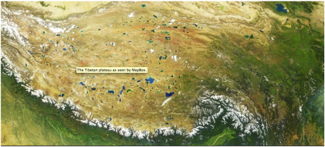
The application can be accessed at https://rosecityresource.streetroots.org/ https://www.mapbox.com/webinars/storytelling-template-live-demo/?utm_medium=email&utm_source=blast&utm_campaign=email|blast|storytelling-template|livestream-demo-20-04&utm_term=storytelling-template&utm_content=livestream-demo
Live-coding demo: How to use the Mapbox Storytelling Template to create a story map Maps make data understandable, powerful and memorable. Join this session to learn how to use our “Storytelling Template” to quickly build an interactive experience with high-quality map visuals. This storytelling format — sometimes called “scrollytelling” — lets you include as much context as you want, and define the locations your users look at. It’s a great way to bring stories to life. You’ll learn how to...
Who:
At Axis Maps, our aim is to bring the traditions of cartography to the web. We design and build custom interactive web maps for a wide range of clients, focusing on clear design founded on good cartographic principles. Whether it’s a public health map, an animated earthquake map, a live election map, an interactive museum exhibit, or a historical mapping platform, we strive to build the design best suited to our clients’ data and audiences. What: We are seeking a full- or part-time web map developer to help bring our designs to life. As a developer, you will largely be responsible for writing code that powers our maps, but your cartographic and interactive design skills will also help us make the best maps possible. Please see the skills and qualities we’re looking for below, and apply if they sound like you! We encourage and welcome people of any background, gender, ethnicity, ability, and sexual orientation to apply. We need someone with these qualities:
Other helpful qualities:
Where: Anywhere—this is a remote job—but UK and central/eastern USA are preferred, as we are based in those countries and time zones. When: Now! Please apply by Wednesday, 4 September 2019. How: Please email Andy Woodruff at [email protected] and include:
Did you know you can edit ESRI basemaps?? You can: https://developers.arcgis.com/vector-tile-style-editor/
The Northwest GIS User Group (NWGIS) is sponsoring three separate one-day WebAppBuilder workshop in February and March 2017. The workshop is being offered in Boise, Eugene and Olympia and the registration fee is being subsidized by NWGIS.
Purpose: Provide an educational benefit to members of NWGIS. Provide three one-day workshops in a classroom setting on Esri’s ArcGIS online WebAppBuilder in Idaho, Oregon and Washington. Trainer: The trainer will be Eric Pimpler of GeoSpatial Training Services (the link is external). Format: Classroom style training with each student bringing their own laptop. Handouts will be provided. Workshop Support: Attendees are responsible for their own parking and lodging before and/or after the training. Information about parking and the training room will be sent to registered attendees. A lunch will be provided as part of this workshop. Each workshop will be limited to 24 participants. A waiting list will be maintained. Registration: Registration is online using the NWGIS web site. The fee is $60 per student. The Northwest GIS User Group is subsidizing the three workshops up to $2,000. Cancellations will be permitted up to two weeks prior to the training. Less than two weeks prior to the first class, refunds will not be offered, but substitutions will be possible at any time. Registered students whose plans change can contact individuals on the waiting list to facilitate substitutions. Locations & Dates: Class begin at 8:30 AM, there will be a one-hour lunch break, and conclude about 4:30 – 5 PM. The locations and dates are:
 Making data beautiful - another reason to learn TileMill for web mapping!
To read the full article: http://www.wired.com/design/2013/05/a-cloudless-atlas/  Frank Biasi's will be presenting a webinar -- Integrating Multimedia and Maps to Tell Stories and Engage the Public -- next Wednesday, March 13th at 12 noon, Eastern Time. Frank is the Director of Digital Development with National Geographic Maps and he has a lot of fascinating conservation GIS information to share with us. Please click here for more details and follow the instructions below to join the discussion. Topic: Integrating Multimedia and Maps Date: Wednesday, March 13, 2013 Time: 12:00 pm, Eastern Daylight Time (New York, GMT-04:00) Meeting Number: 825 742 753 Meeting Password: WCS4scgis ------------------------------------------------------- To join the online meeting (Now from mobile devices!) ------------------------------------------------------- 1. Go to https://nethope.webex.com/nethope/j.php?ED=181079912&UID=0&PW=NYTQwN2QzNzVm&RT=MiMxMQ%3D%3D 2. If requested, enter your name and email address. 3. If a password is required, enter the meeting password: WCS4scgis 4. Click "Join". To view in other time zones or languages, please click the link: https://nethope.webex.com/nethope/j.php?ED=181079912&UID=0&PW=NYTQwN2QzNzVm&ORT=MiMxMQ%3D%3D ------------------------------------------------------- To join the teleconference only ------------------------------------------------------- Call-in toll-free number: 1-866-3864210 (US) Call-in number: 1-443-8636601 (US) Show global numbers: https://www.tcconline.com/offSite/OffSiteController.jpf?cc=4140170678 Conference Code: 414 017 0678 ------------------------------------------------------- For assistance ------------------------------------------------------- 1. Go to https://nethope.webex.com/nethope/mc 2. On the left navigation bar, click "Support". You can contact me at: [email protected] 1-718-741-8206 This is an article about gun rights, maps, and privacy - thought some people would find it interesting!
http://www.cnn.com/2012/12/25/us/new-york-gun-permit-map/index.html?hpt=hp_c1 The Oregon Web Map Developers need your participation in the review of a few web mapping applications.
Please help us provide better services to the public (and to you) by reviewing any of the web mapping applications listed below and completing this survey: http://www.surveymonkey.com/s/PW8P7NR Five web mapping applications created by Oregon state agencies would like to gather feedback to improve this and future applications. Please complete the survey for any one of these applications. You may complete a survey for as many of these applications as you would like. Each application should have its own survey. These applications are: 1) ODOT's Oregon TransGIS (https://gis.odot.state.or.us/transgis/ ) 2) DOGAMI's Statewide Geohazards Viewer (http://www.oregongeology.org/hazvu/ ) 3) OWEB's Improving Habitat Access for Fish (http://www.oregon.gov/OWEB/MONITOR/pages/fishpassage_viewer.aspx ) 4)OWEB's Investment Tracker ( http://www.oregon.gov/oweb/docs/oitt.html ) 5) OWRD's Water Rights Mapping Tool (http://apps.wrd.state.or.us/apps/gis/wr/ ) Review ends January 2, 2013 |
Categories
All
Archives
June 2024
|
 RSS Feed