|
"I wanted to let you all know of a workshop opportunity to learn R in Santa Barbara, California. We have a scholarship open for students and early career professionals which covers tuition, travel, and lodging for the entirety of course. There are still spots available, so if you're interested in learning or refining your R skills, consider applying! See details below:
UC Santa Barbara’s National Center for Ecological Analysis and Synthesis (NCEAS) Learning Hub is hosting our next coreR course in October 2024. This is a five-day introductory course on collaborative, open, reproducible, and essential data science skills. We encourage everyone and anyone at any stage of their career to register. The bare minimum is some familiarity with R programming. Course Details
For more information, please visit the course website. We encourage students and early career researchers, especially those from underrepresented backgrounds, to apply for our Director’s Scholarship (we are awarding 3 scholarships for this course). This award covers tuition, travel, and lodging for the coreR course. Apply online by August 16, 2024. Please note the deadline for the scholarship is before the coreR registration deadline. Please reach out to [email protected] with any questions." You and your students are invited to the 2024 NWGIS User Conference in Seaside, OR from September 23-26. New this year, we are having a juried poster session with two $100 Amazon gift card prizes for the overall conference favorite and NWGIS Board favorite. As part of the submission, your students will give a 5-10 minute presentation on their research during a technical track session on Wednesday instead of the typical poster session format. Winners will be announced Wednesday afternoon before the closing Keynote.
Students that submit a poster will receive a $50 discount code on their registration fee. A 1-day student registration fee is $100 and a 2-day fee is $200 before the discount. Please have your students submit their posters to me, and if accepted, they will receive a discount code for registration. We are also welcoming presentations from professors and students up to 20 minutes in length for our technical tracks. Presenters also receive a $50 discount on registration. The deadline for poster submission is Friday, Sept 13 by 5pm PST. The SPLIT Geoscience workshop provides intensive hands-on learning events to solve real-world geoscience problems using the most recent geospatial techniques learned from experts. This workshop is for undergraduate and graduate students and is being hosted at Idaho State University. It is a collaborative project between OhioView, LouisianaView, and IdahoView. The workshop is being held in-person from May 6-10 and there are several travel grants available to help with travel costs. Contact Anita Simic-Milas if you have any questions, [email protected]. 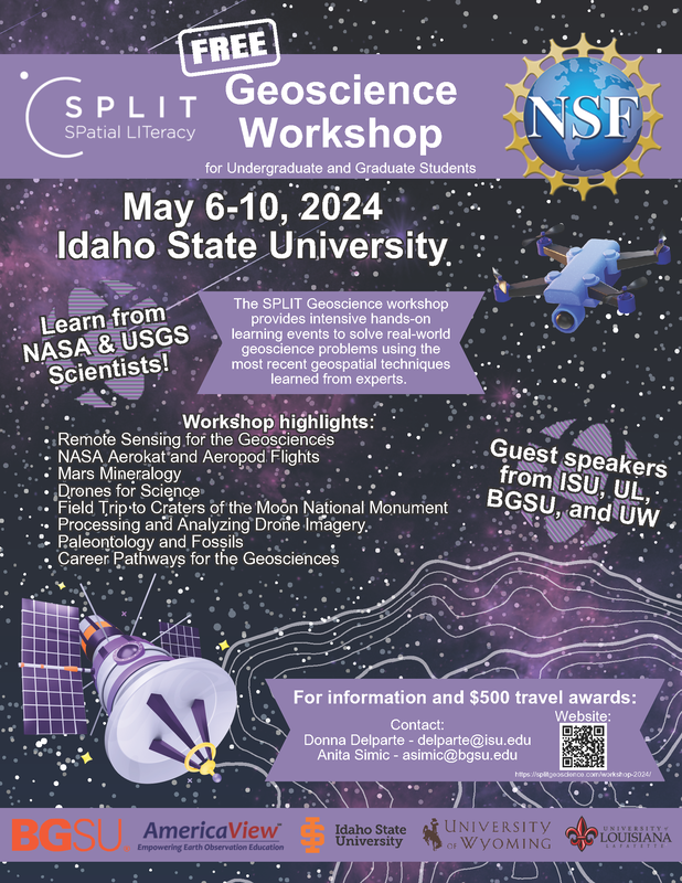 Collecting and Managing Data to Support Hazard Risk Assessment – format/build your own datasets for use in HAZUS!
Portland, OR Monday, May 20th through Wednesday, May 22nd 8:30 to 4:30 Pacific and Thursday, May 23rd from 8:30 to 11:30 This workshop provides a working knowledge of the building, infrastructure, population, agriculture, and other data needed to support the modeling and characterization of risk from earthquake and flood hazards in FEMA Region 10. The workshop offers guidance on inventory collection strategies that are independent of the tool used to assess risk. Focus is given to inventory elements required by Hazus, with an emphasis on components that are most important in terms of defining hazard related economic and social impacts to FEMA Region 10 states. Multiple opportunities are provided for hands-on exploration and management of inventory data. For additional information and to register/enroll please contact Kara Jacobacci <[email protected]>.  Cartography., esri's highly popular massive open online course (MOOC), is for anyone who wants to explore the art and science of mapmaking using ArcGIS Pro.
Over six weeks, learn essential cartography concepts from Esri experts and pick up tips and tricks to craft impactful maps that showcase your data. Join the course and try the latest ArcGIS Pro mapping and data visualization capabilities for yourself. Cartography. April 3–May 15, 2024 The Training Team Register Now → The course includes the following:
Open House | OSU Online MS Geography and Geospatial Science Program | March 14 at 3:00 PM
• Come and Join Us on Zoom for an Online Q&A session! • Get your questions answered about how you can get your Master’s online degree in Geography and Geospatial Science! • Meet and Speak to the Geography Program Coordinator! • Learn How to Apply! Join Zoom Meeting https://oregonstate.zoom.us/j/97553614040?pwd=RXE2WEdXazdDTHFDdjBCTFFOYlZ4QT09 Join our free Conservation GIS Meetup, co-sponsored by the Society for Conservation GIS and Map Nerd Consulting, on Thurs. March 14th @ 9am PT/ 12pm ET / 5 pm GMT. Connect with your colleagues from around the world and celebrate the conservation community!
This virtual meetup and networking hour is an opportunity to learn about SCGIS and connect with like-minded individuals passionate about conservation GIS. There will be breakout rooms to give everyone the opportunity to discuss a range of GIS topics and expand your network. Virtual meetups will be held on a quarterly cadence so we hope to see you there! Register here: https://us06web.zoom.us/meeting/register/tZYsf-Gprj0tHdJKZKp4xXxOlVWCkx030WSi#/registration All are welcome to join this event so please share with your networks, and special thanks to those who support our SCGIS community as active members!
Please join the Society for Ecological Restoration for an exciting discussion on “Careers in Environmental Restoration” happening Thursday, February 29th, 2024 from 12 pm - 1 pm PST on Zoom (Register Here) - hosted by the Society for Ecological Restoration (SER) Northwest Chapter. The conversation will feature four powerful practitioners from across the broader Northwest region of the US, showcasing different sides of the restoration industry: nursery management, restoration consulting, and non-profit stewardship:
The panelists will tell stories of their career paths and offer insider tips for growing as a leader in the restoration industry. We will also discuss how to start SER associations at Universities, and ways to get involved in the upcoming SER 2024 North American Conference this November. Register here for the Panel, and be sure to spread the word to students and emerging professionals in your networks! 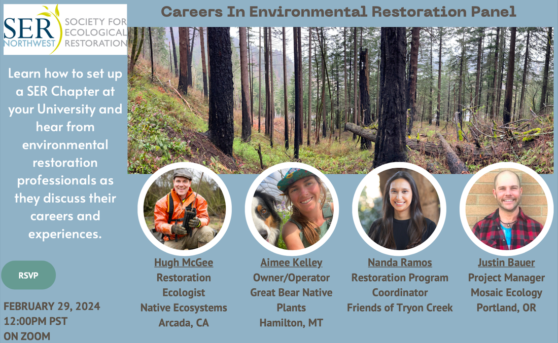 |
Categories
All
Archives
June 2024
|
 RSS Feed