CHRISTINA FRIEDLE
  • Home
  • About Me
  • Portfolio
  • Resume | CV
  • Contact
  • Blog

geospatial: jobs| internships | events | news | more

ASPRS Technical Exchange Oct 25 (Vancouver, WA)

10/4/2024

 
2024 Fall Technical Exchange Meeting
 
Event:             2024 Fall Technical Exchange Meeting, Sponsored by the Cascadia Region of the ASPRS
When:             October 25, 2024
Where:            Water Resources Education Center, Vancouver, WA 98668
Who:               Presentations and workshops by Professionals, Educators and Researchers.

The technical exchange is a one-day event in which local practitioners may present a talk on one of their current or recent projects. This is also an opportunity to learn new techniques, meet new contacts, and refresh old ones. We have some great talks lined up!

Final call for presentations!
 Presentations can be 5-minute lighting talks or ~20-30-minute presentations with time to allow for questions and discussion. Maximum 1 hour. Projectors and computers will be available.  Registration and onsite lunch will be provided at no cost.

Registration

Here is a link to the eventbrite page. This is a no-cost event, but it will help us plan for food if we get everyone registered. 2024 ASPRS Cascadia Technical Exchange Registration

ASPRS Cascadia is also offering a $300 award for students and emerging professionals to present at a local conference or event. The tech exchange is a great opportunity! For an application, please contact Jimmy at the email below.


If you are interested in presenting, please submit a brief description of your topic to Jimmy Schulz by Friday Sept 27, 2024.  Jimmy’s email address is [email protected].
​
Register Here

Drone Surveyor & Photographer w/ Sester Farms (Gresham, OR)

2/12/2024

 
https://www.simplyhired.com/job/Dxzdg8GP-BIRw1-NQwdlQhOREdIo4BiBIUbjh_vwkgBmCH3TkWFRUA

Full Job Description
Job description
Sester Farms is looking for a perfection-minded commercial drone pilot with knowledge of land surveying and photography who wants to grow with the company long-term while driving company growth. By maintaining accurate and detailed customer records and showcasing the pride and dedication we take in growing beautiful plants, the person in this role will support the sales team and promote the Sester Farms brand.

Qualifications:
  • Excellent customer service skills: Empathy for the customer, enjoyment of solving problems, clear communication, and a learning mindset.
  • High proficiency with Microsoft Office Suite and Windows OS.
  • Experience with creating photos and videos with a drone required.
  • Experience or willingness to learn geofencing technologies.
  • Intermediate Excel knowledge.
  • Drive to initiate actions independently.
  • Excitement to learn all aspects of the business.
  • Horticulture and/or nursery experience is a plus but not required.
  • Willingness to work outdoors in inclement wearther.
  • Bi-lingual (Spanish) is a bonus.

Duties (not limited to):
  • Generating photo and video content to be used internally and externally of various plants and property throughout the year.
  • Development of geofenced areas for better product tracking or recording.
  • Work with the Marketing Manager and directly with the company owners to build Sester Marketing into a dynamic and powerful leader in the nursery industry.

Sester Farms is a dynamic and growing, multi-generational, industry-leading wholesale nursery based in Gresham OR. The climate and soil in NW Oregon, combined with our extensive horticulture expertise, allow us to grow beautiful, award-winning trees and shrubs at an amazing pace. Our dedicated people manage every aspect of growing, managing inventory, selling, and shipping these plants to much of the lower 48, Alaska, and Canada, with the finance, maintenance, and software development teams keeping all of the processes running smoothly.
Come join Sester Farms for an engaging career where initiative and dedication are highly valued along with true teamwork, supporting any process or team that needs it regardless of job title.
Compensation will be offered commensurate with experience.

Benefits: Paid Time Off, 401k with excellent employer match (after a waiting period), health, dental, vision insurance, health savings card, Flexible Spending Account, etc.

Work to be performed on-site, in Gresham, OR.

Please submit a resume and a cover letter explaining why you think you'd be a good fit for this position.

Job Type: Full-time

​Pay: $55,000.00 - $85,000.00 per year

​Benefits:
  • 401(k)
  • 401(k) matching
  • Dental insurance
  • Flexible spending account
  • Health insurance
  • Health savings account
  • Life insurance
  • Paid time off
  • Vision insurance

​Schedule:
  • Day shift
People with a criminal record are encouraged to apply

Experience:
  • Marketing: 2 years (Preferred)

Ability to Relocate:
  • Gresham, OR 97080: Relocate before starting work (Required)

Work Location: In person

GIS/UAS intern with South Slough (Charleston, OR) - APPLY BY 3/14/24!

2/5/2024

 
The South Slough Reserve is recruiting for a GIS/UAS intern for this summer with a focus on habitat restoration!

​Check out the details on the website:
https://www.oregon.gov/dsl/SS/Pages/GetInvolved.aspx
Picture

Geospatial Team Lead w/Bat Conservation International (PNW, Remote)

12/13/2023

 
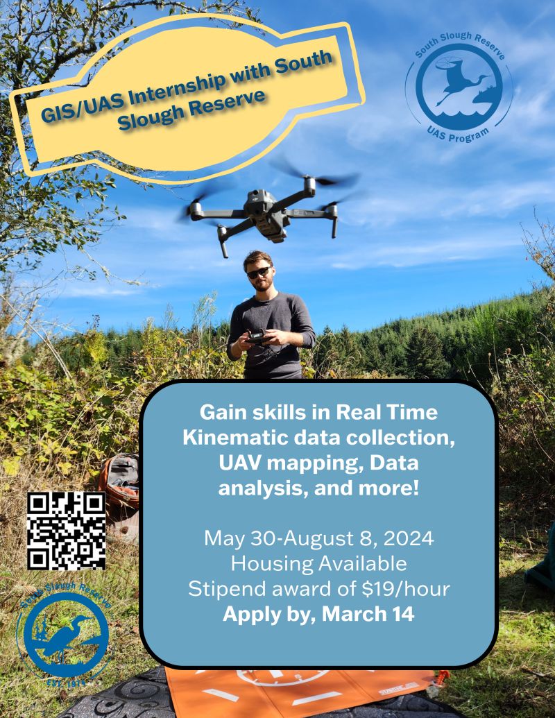
https://workforcenow.adp.com/mascsr/default/mdf/recruitment/recruitment.html?cid=4f1d76c0-c801-4a5e-879d-35f46070697c&ccId=19000101_000001&jobId=520891&lang=en_US&source=EN

​
Bat Conservation International
Geospatial Team Lead

Status: Full Time, Salaried
Location: Remote in the Western United States
Reports to: Director of Habitat Protection and Restoration (HP&R) (Jason Corbett)
Supervises: GIS Analyst & UAS Pilot Lead
Key Relationships: Director HP&R, Subterranean Team Lead, Restoration Team Lead, Director, Endangered Species Interventions (ESI), Chief, Global Conservation and Strategy
Salary: $75,000 annually + benefits
 
BCI and our Mission
Bat Conservation International (BCI), a 501(c)(3) nonprofit organization dedicated to ending bat extinctions worldwide, seeks a Geospatial Team Lead to join BCI’s HP&R Program. The Geospatial Team Lead must be highly collaborative and enjoy working within an environment that is mission and results-driven, where they can bring their whole self to work and contribute to the mission of BCI, the HP&R program, and lasting, positive ecological change.

​BCI is a distributed organization with staff across the United States. The Geospatial Team Lead can live anywhere in the western US but will be coordinating conservation projects across the globe, emphasizing the southwestern United States, particularly in New Mexico, Arizona, Colorado, and Utah.


Primary Responsibilities and Expectations
The Geospatial Team Lead will lead, manage, and occasionally perform a variety of conservation activities that benefit bats and their habitats. They will oversee project management, supervise the growing geospatial team, assist with production work, optimize databases, and develop new workflows as needed. Occasional field work will be required to understand existing workflows, conduct data collection, assist with UAS operations (with the option of training to become a remote pilot), test new workflows, scout project sites, and train staff in new workflows.
This position is ideal for a data manager, data scientist, biologist, natural resource manager, or conservationist with interest and experience conducting/managing geospatial work across various platforms and landscapes.

Position Description:
The Geospatial Team Lead will:
  • Lead geospatial project management and organization. 
  • Act as the main point of contact and administrator of BCI’s organizational AGOL account and geospatial licenses.
  • Maintain geospatial and non-geospatial databases.
  • Manage growing geospatial team (currently 1 GIS analyst and 1 UAS lead) and hire as needed.
  • Build relationships and work with project partners to attain or send various geospatial data, which may include developing storage and viewing capacity for these partners.
  • Develop and update training documentation on current and future workflows
  • Support conservation field staff by setting up data collection methods in ArcGIS Field Maps and Survey123 Connect.
  • Assist and train field staff to access data, use geospatial tools and support with troubleshooting various geospatial hardware and software.
  • Processing, quality control, and producing deliverables from LiDAR data.
  • Create quality map products in ArcGIS Pro for project reports, proposals, communicating conservation objectives and inform planning efforts.
  • Assist with project reporting and coordination with project partners.
  • Research and development work (integrating new technologies into data collection and management such as UAVs, custom applications, etc.).
  • Test new geospatial hardware & software, and/or train field staff in geospatial data collection (in the field and/or remotely).

Ideal Candidate Qualifications:
Required Knowledge/Experience
  • Four years of relevant work experience, a GIS Certificate (from either a university or community college) and/or a Bachelor’s degree in Geography, Environmental Studies, Biology, Wildlife Biology, Wildlife Sciences, Natural Resource Management, or other similar degrees.
  • Advanced experience in the use of GIS for analyzing and managing data, and creating maps.
  • Advanced experience in ESRI software products such as ArcGIS Pro, ArcGIS Online, ArcGIS Dashboards, Field Maps, and Survey123/Survey123 Connect.
  • Advanced experience with remotely sensed data and field data collection.
  • Experience with LiDAR data
  • Experience training individuals and groups on equipment, software, or hardware use.
  • Experience in leading, managing and supervising a team (or department) and administering a budget. 
  • Proficiency in spoken and written communication in English by email, Zoom communications, in-person meetings and in-person presentations to staff, stakeholders, and partners.
  • Cartography skills and experience creating cartographic and spatial data visualization products for static and dynamic (web-based) map applications.
  • Database creation, management, and maintenance experience.
  • Demonstrated ability to manage projects, including management and coordination of remote staff and external partners
  • Proven success in independently managing multiple tasks/projects simultaneously and accurately with attention to detail and the ability to prioritize under the pressure of deadlines
  • Ability to work, communicate, and ask for support effectively with all levels of staff, government agencies, industry, landowners, and other partners.
  • Ability to occasionally work and hike in remote environments with accompanying gear.

Preferred Knowledge/Experience
  • Experience with Cloud Compare and/or GeoSLAM Connect
  • Experience with handheld, terrestrial LiDAR scanning (especially with GeoSLAM units)
  • Interest in collecting and processing UAS data from fixed-wing or multirotor UAV’s
  • Experience in natural resource restoration, conservation and/or monitoring. 
  • Creating geospatial python scripts
  • Extensive experience working in dynamic and remote outdoor environments
  • Experience and/or interest in engaging with different communities and developing opportunities that encourage and grow a diverse, equitable, and inclusive conservation community.

Work Characteristics and Competencies:
  • Strong interpersonal skills and creative problem-solving
  • Detail-oriented, self-motivated, and self-starter 
  • Seeks out adversity and has high emotional awareness
  • Highly collaborative with a growth mindset and enjoys challenges
  • Willingness to be flexible and adaptive
  • Highly curious and have a deep desire to learn new things 
  • Contributes to a healthy workplace and organization

Justice, Equity, Diversity & Inclusion (JEDI)
BCI is deeply committed to JEDI and embeds JEDI-centered practices in the conservation work and organizational culture. BCI is determined to be an employer of choice and believes that the best organizational performance will come from a safe, diverse, and inclusive work environment. Read more about our JEDI statement at www.batcon.org/about-us/justice-equity-diversity-and-inclusion/.

To Apply: 
If you have 70% or more of the desired qualifications, we encourage you to apply. Individuals interested in applying should upload their resume and cover letter to the application portal. In the cover letter, please explain how your work and lived experiences have prepared you to be successful in this position, what you find compelling about this job, and how you (and your career) will benefit from this position.

Applications are due by midnight on 5 January, 2024. Interviews will be held mid to late January, 2024 with a tentative start date of end of February, 2024. 


All applications are reviewed within ADP Workforce Now (https://1.adp.com/qQk4NNunyS4). 


Compensation and Benefits
  • $75,000 annually, full-time salaried. Paid biweekly electronically or via check.
  • Compensation package includes generous paid vacation and sick time; 401(k) plan with employer match; health, dental, and vision insurance plan.  
  • Organizational culture that supports staff well-being and professional development.

GIS & UAV Technician w/ Vermont Association of Conservation Districts (Colchester, VT)

9/18/2023

 
https://www.vacd.org/job/gis-aerial-unmanned-vehicle-uav-technician/

Have a passion for digital map making and dream of piloting an UAV?  Use that passion in service of the State’s efforts to develop and implement climate smart practices on Vermont’s farms and forests!
The Vermont Association of Conservation Districts (VACD) seeks qualified applicants for a full-time GIS/Aerial Unmanned Vehicle (UAV) Technician position. The GIS/UAV Technician’s Home Office will be at the NRCS State Office in Colchester. The GIS/UAV Technician will be part of a team responsible for coordinating VACD’s sUAV program while also supporting Natural Resources Conservation Service (NRCS) GIS Specialist in providing state-wide GIS, cartographic and business and mobile tool technical assistance to the NRCS Resource Team as well as conservation planning field staff.    There will regular scheduled opportunities to Telework. The GIS/UAV Technician will have a working knowledge of natural resources, agriculture, or water quality, coursework and proficiency with ArcPro and cartographic imagery, the ability to work independently and be comfortable with field work on farms.  Experience operating Unmanned Aerial Vehicles including RTK Quadcopters and an understanding of data retrieval and processing are preferred. Having or working towards of a FAA Part 107 Remote Pilot Certification is desired.  A Bachelor’s degree with an interest in conservation is required. Starting salary is $20.45 per hour and includes yearly salary advances, health benefits, participation in an employer contribution 401K plan and a generous sick, holiday and vacation leave package.
The Technician will be part of the team which has responsibility for supporting the Natural Resources Conservation Service (NRCS) GIS Specialist in providing state-wide GIS, cartographic and business and mobile tool technical assistance as part of the NRCS Resource Team.as well as being a member of VACD’s sUAV program team responsible for coordinating and completing projects.  The Technician’s Home Office will be at the Colchester NRCS/USDA State Office.  While the Home Office will be at the State Office classified as the Technician’s Duty Station there is the expectation that there will regular opportunities to Telework as well as instances and opportunities to “Hotel, or Touchdown” when necessitated by working in NRCS’ Field Offices throughout the Vermont. 

GIS Technician Duties and Responsibilities – .50 FTE
The purpose of the GIS Technician position is to assist and support Natural Resources Conservation Service (NRCS) field and state office staff in planning and implementing conservation practices in order to reduce phosphorus and sediment loading resulting in adverse impacts to water quality of Vermont’s rivers and water bodies. Working with technical direction provided by NRCS’ GIS Specialist or designee the Technician’s responsibilities may include: 
  • LiDAR derivative products & procedure development
  • Provide Technical Assistance on ArcMap and ArcGIS Pro. Assist Field Office Soil Conservationists, Engineering Staff and/or Conservation Planers as requested and available.
  • Publish content to ArcGIS Online and ArcGIS Enterprise Portals and support the GIS Specialist in maintaining the online geodata library
  • Develop and update Mapping and Workflow Automation tools including the use of templates, python or other coding language, and new technologies
  • Provide updates through outreach avenues (Microsoft Teams channel, newsletter, office hours, Storymap, etc) with helpful workflows, technical tidbits and basic procedures
  • Use Conservation Desktop to support field staff including delineate/digitize and attribute customer tract and field boundaries, planned conservation practice locations and quantities
  • Support of NRCS’ Mobile Tools initiative and effort that may include assisting users with troubleshooting and problem solving.
​
Small Unmanned Aerial Systems (sUAS) Program Duties and Responsibilities– .35 FTE
As a VACD sUAS team member the sUAV Technician will continue the effort to develop, coordinate and implement the sUAS program. This work may over time and with experience include:
  • Attaining and maintaining FAA Part 107 Remote Pilot Certification as a VACD sUAS pilot;
  • Completing project requests including project planning and coordination, flight, processing, geospatial product creation, and deliverables to internal clients;
  • Maintaining flight checklists (Survey123), flight log, maintenance schedule, and record-keeping of time metrics;
  • Training field staff as Visual Observers and in usage of geospatial product data;
  • Carry out outreach, such as on Teams Channel, Newsletter, Storymap, etc. Deliver presentations to internal (VACD and NRCS) and external clients;
  • Collaborate with other sUAS team members for project scheduling, vehicle charging and maintenance, troubleshooting, research, etc.;
  • Explore and analyze new uses for sUAV for improving conservation planning;
  • As needed and capable research and draft proposals and other documents including progress and grant reports to support the sUAV program’s growth.
 
Wetlands Easement Support Assistant Duties and Responsibilities  .15 FTE
The responsibilities of the Wetlands Easement Support Assistant portion of this position will provide assistance to NRCS Wetland and Resource staff and may include the following specific tasks:
  • Assist with planning and monitoring of wetland easements including:
    • map creation involving wetland easements
    • compiling and tabulating natural resources inventory data
    • conducting field surveys
    • photographing, collecting, and analyzing field data and aerial photo
    • monitoring conserved easements
  • Assist with wetlands restoration conservation practice implementation
  • Assist with wetland determinations including describing soils, inventorying vegetation, and identifying wetlands hydrology
 
The GIS/sUAV/NR Support Technician will be an employee of VACD.  VACD will provide overall administrative, HR support and supervision carried out chiefly by the VACD Conservation Program Manager. Responsibility for day-to-day assignments and technical oversight may be provided by NRCS GIS Specialist, as well as members of NRCS Resource Team or designee.  Training, technical guidance and workload prioritization will be discussed with VACD’s Conservation Programs Manager in consultation the NRCS.  Any changes in duties and program direction will be discussed with representatives from NRCS and VACD Conservation Programs Manager and approved by the VACD Executive Director.

Salary and Benefits
This is a full-time, non-exempt position, with starting wage of $ 18.45 per hour. After successful completion of the first year of service position salary will advance along a path equivalent to the Federal General Services GS 6 pay grade starting at Step 2. In addition the position is eligible for yearly Cost of Living Allowance (COLA) increases as determined by the US Office of Personnel Management (OPM) at the beginning of each calendar year. The benefits include contributions to VACD’s Cafeteria Health plan, participation in employer contribution 401 K plan and generous, sick, holiday and vacation leave. 
 
Training and Professional Development
The sUAV/GIS Technician will receive orientation and training from VACD, NRCS and other partners and will have multiple opportunities for professional development as approved by the VACD Conservation Programs Manager.
 
Reporting
Monthly narrative and statistical reports will be submitted for review to the VACD Conservation Program Manager. 

Qualifications
  • Bachelor’s degree in natural resources, geospatial science, agriculture or related subjects preferred. A working knowledge of natural resources, agriculture, and water quality issues a plus.
  • Knowledge, course work and proficiency ArcGIS and coding languages. Experience working with topographic maps and aerial photos or LIDAR.
  • Experience operating Unmanned Aerial Vehicles including RTK Quadcopters, and understanding of data retrieval and processing is preferred. Holding of or working towards a FAA Part 107 Remote Pilot Certification is desired
  • Successful grant writing and program coordination would be valuable.
  • Computer proficiency, particularly with Microsoft Office, Excel and database programs
  • Strong interpersonal, written, oral communication and presentation skills
  • Able to work independently
  • Detail oriented in data collection and organization
  • Comfortable with field work on farms and in direct contact with farmers
  • Knowledge and demonstrated commitment to conservation and stewardship of natural resources, sustainability and ecological processes is required
  • Eligible to be cleared to use the USDA computer network is required.

Send resume, cover letter and contact information for three professional references by January 24th to VACD, c/o Amanda Harris at [email protected], or PO Box 889, Montpelier, VT 05601

GIS Analyst w/City of Salem (OR)

8/9/2023

 
https://www.governmentjobs.com/careers/cityofsalem/jobs/4141686/gis-analyst-public-works 

Make an impact:
This exciting position will help refine an existing GIS based asset management system as well as support the stormwater utility in data collection, web GIS, and analysis. The position will work in a team environment that supports the entire Public Works Department.

​Learn and grow:

Teamwork drives our growth mindset, leading to training, conferences, user groups, awards, and collaborating on solutions. You will be contributing to a City that is maturing into data strategies and governance, where data and its value is becoming essential for managers who make policy and operational decisions. Opportunities will arise to develop leadership skills by serving as a technical project manager on small and moderate projects. You will be able to accomplish your goals through our values of interpersonal skills, thoroughness, accountability, and a positive culture. We pride ourselves on a proven track record of providing opportunities for innovation, career development, flexible work schedules, and great work-life balance.

What you will do:

Be the technical lead of the City of Salem stormwater utility’s GIS data, asset management and analysis needs. You will also serve in the Public Works Unmanned Aircraft Systems (UAS) program as an Unmanned Aerial Vehicle (UAV) pilot.

What you will bring along:
  • Experience and skills in the Esri ArcGIS platform and its overall suite of software and apps.
  • Ability to design, develop, and deliver data models and edit spatial and attribute data.
  • Ability to configure and manage Asset Management SaaS solutions.
  • Knowledge of statistics, data research, and spatial analysis to interpret and evaluate.
  • Ability to use dashboards and storymaps to create meaningful reports and stories.
  • Ability to use programming logic to automate and improve processes.
  • Knowledge to improve real-time location intelligence.
  • Demonstrate end user support and customer communication for exceptional outcomes.

What can we offer you for all your hard work?
  • Medical, dental, and vision coverage for you and your family.
  • Paid vacation and sick time in accordance with City policies.
  • Competitive pay.
  • Employer-paid PERS contribution of 6%.
  • Opportunity for voluntary pre-tax contributions to a 457b account.
  • Health care and dependent care flexible spending accounts.
  • Voluntary long-term care.
  • Employee wellness program.
  • Employee assistance program.
  • Employee health clinic.
  • Position schedule is Monday-Friday, between the hours of 8:00 a.m. to 5:00 p.m., flexible hours available. Hybrid work eligible under the City and Public Works
  • Department's Remote Work Policies. Please note this is not a full remote role and will require working on-site a minimum of two days a week.

What are the minimum qualifications? 
  • Must pass the pre-employment background check.
  • Must have an Oregon Driver license and meet the City of Salem's driving standards.
  • Bachelor's degree in geography, planning, engineering, business, computer technology or related course of study; and two years GIS experience which included designing, creating, maintaining and analyzing geospatial and tabular data; and writing GIS script or applications programming, or any combination of experience and training that demonstrate possession of the knowledge, skills, and abilities as listed, and ability to perform the essential job functions. 
  • Must pass the FAA Part 107 exam within 6 months from date of hire and maintain certification during employment.
  • Must meet CJIS (Criminal Justice Information System) registration and requirements within 6 months of hire.

About us:

The City of Salem is the second largest City in the State of Oregon. Located in the lush Willamette Valley, Salem is the capital city of Oregon with a population over 170,000. Centrally located, Salem is 47 miles south of Portland and an hour from the Cascade Mountains to the east and an hour from the ocean beaches to the west. Salem is an exceptional community for living and working with exciting new and comfortable well-established neighborhoods and carefully preserved historic buildings. 

Free esri drone workshop August 1st in Portland

7/18/2023

 
Join Esri and Freefly Systems for full day drone imagery workshop!
 
Whether you are new to using an unoccupied aerial vehicle (UAV) or you have been flying for years this workshop will offer tips and tricks for flight planning, image analysis, fleet management, and how to make shareable information products from drone imagery. The ArcGIS platform supports an end-to-end UAV workflow that can begin processing in both the cloud and in offline environments using desktop machines.  We will demonstrate and discuss how to plan and use the autonomous flight planning software in the Esri platform to build imagery products from 2D and 3D GIS data. We will show the UAV created imagery products from different types of flights and the different types of processing that is available. We will also explore and explain how to configure these processing steps. After the imagery has been processed and we have created the derived products we will show how to analyze and share information using the ArcGIS platform.
 
Additionally, Esri partner Freefly Systems will be presenting their Site Scan integration solution with the Astro drone. The Freefly Astro is a made in the USA solution to drone mapping. The Astro is compatible with Site Scan for ArcGIS and can carry a variety of imaging payload from 61-megapixel RGB cameras, to thermal, and Lidar units.
 
Date: August 1, 2023
Time: 9am-4pm (Doors open at 8:30)
Location:
Esri R&D Center Portland
309 SW 6th Ave Ste. 600
Portland, OR 97204

Interns w/ Bureau of Land Management - deadline 4/19!

4/16/2023

 
The Bureau of Land Management is hiring 100 interns to work with the federal government on public lands. 

​16.1 million acres of BLM land are covered by the Bureau in Washington and Oregon with interns needed in a variety of roles.

Positions available include roles in civil engineering, public affairs, information technology, natural resources, wildland fire, GIS and environment protection.


​Interested students can apply to multiple positions as applications close on April 19.

CAD/GIS Technician w/Aerotas

4/16/2023

 
https://www.indeed.com/cmp/Aerotas-2/jobs?jk=4a79bf32e9477a49&start=0&clearPrefilter=1

Aerotas is a technology-enabled services company that delivers survey-grade CAD files created from drone-collected data in days, not weeks. Data is handled by ASPRS Certified Photogrammetrists and CAD Technicians ensuring quality check at each stage. Drone photogrammetry and CAD drafting services are enabled by a combination of advanced technology, high-performance computing architecture, and human expertise — providing fast and predictable turnaround times, lower drone survey costs, and the most accurate deliverables anywhere to 1,500+ leading survey and civil engineering firms across the nation.

​We Value: Efficiency, Quality, Data

GIS / CAD Tech
We are growing fast and need your curious and futuristic mind! You will be working with the data team processing aerial drone output - converting it into compatible format for our clients ensuring high quality and accuracy. This is a brand-new field, and we are leading the way. You are early in your career with at least 2 years of experience in CAD or GIS technologies. You have an eye for detail and find rapidly changing technology exciting. If you are looking for a challenging career that involves flying lasers, let’s talk!

You Value: Data, Integrity, Efficiency

Spend your days:
  • Assisting in drafting and extracting of aerial drone land survey data using 3D drafting software
  • Creating detailed, high-quality topographic maps and planimetric data from complex 3D models
  • Ensuring quality at all levels by assisting in the review, auditing, and quality analysis of digitized data
  • Identifying and implementing automation tools to improve workflows
  • Communicating and collaborating with remote teams and individuals, both technical and non-technical
  • Working as a team in a fast-paced, growing environment where flexibility is a must!
  • Reinforcing our commitment to clients and always being focused on their satisfaction and future needs

What you’ll bring with you:
  • Undergraduate degree and at least 2 years of experience in CAD, GIS, mapping or surveying
  • Knowledge of GPS technology and concepts - ESRI, ArcGIS, Raster
  • Experience or strong interest in Land Surveying, CAD, GIS, and mapping - 3D mapping or modeling experience will get our attention!
  • An insatiable curiosity for futuristic technology and continuous learning – your family lovingly calls you a geek
  • Strong communications skills – comfortable getting your message across in a virtual world
  • Detail-oriented and organized – you can manage multiple projects while focusing on the details to ensure accuracy
  • A knack for picking up and implementing new concepts quickly
  • Naturally self-directed, resourceful, with an agile mind that is able to switch priorities quickly

And what you’ll get in return:
  • Competitive Salary and a nice suite of benefits
  • Remote work to enhance your lifestyle
  • Flexible work schedule and unlimited time off
  • The opportunity to be part of a futuristic, fast-moving company

Job Type: Full-time
Pay: $50,000.00 - $60,000.00 per year
Benefits:
  • Dental insurance
  • Health insurance
  • Paid time off
  • Vision insurance

Schedule:
  • 8 hour shift
  • Monday to Friday
  • Overtime
  • Weekend availability

Application Question(s):
  • Which CAD software have you worked with?
  • Have you ever worked with GPS software (ESRI, ArcGIS, Raster)? If so what ones, and how would you rank your level of proficiency (1 [beginner] - 5 [expert])?
  • Are you able to work west coast hours (9-5 pt)?

Education:
  • Associate (Required)

Experience:
  • Land Surveying / Civil Engineering: 1 year (Preferred)
  • CAD: 2 years (Required)

Work Location: Remote

sUAS & GIS Tech w/ Vermont Association of Conservation Districts

1/22/2023

 
The sUAV/GIS Technician will be part of the team which has responsibility for coordinating VACD’s sUAV program while also supporting the Natural Resources Conservation Service (NRCS) GIS Specialist in providing state-wide GIS, cartographic and business and mobile tool technical assistance as part of the NRCS Resource Team.  The sUAV/GIS Technician’s Home Office will be determined based upon the geographic location of selectee.  While the Home Office will be in one of NRCS’ Field Offices or State Office classified as the Technician’s Duty Station there is the expectation that there will regular opportunities to Telework as well as instances and opportunities to “Hotel, or Touchdown” when necessitated by working in NRCS’ Field Offices throughout the Vermont. 

Small Unmanned Aerial Systems (sUAS) Program Duties and Responsibilities – 0.50 FTE
As a VACD sUAS team member the sUAV Technician will continue the effort to develop, and implement the sUAS program. This work may over time and with experience include:
  • Attain and maintain FAA Part 107 Remote Pilot Certification as a VACD sUAS pilot;
  • Complete project requests including project planning and coordination, flight, processing, geospatial product creation, and deliverables to internal clients;
  • Maintain flight checklists (Survey123), flight log, maintenance schedule, and record-keeping of time metrics;
  • Train field staff as Visual Observers and in usage of geospatial product data;
  • Carry out outreach, such as on Teams Channel, Newsletter, Storymap, etc. Deliver presentations to internal (VACD and NRCS) and external clients;
  • Collaborate with other sUAS team members for project scheduling, vehicle charging and maintenance, troubleshooting, research, etc.;
  • Explore and analyze new uses for sUAV for improving conservation planning;
  • As needed and capable research and draft proposals and other documents including progress and grant reports to support the sUAV program’s growth.

GIS Technician  Duties and Responsibilities – .35 FTE
The purpose of the GIS Technician position is to assist and support Natural Resources Conservation Service (NRCS) field and state office staff in planning and implementing conservation practices in order to reduce phosphorus and sediment loading resulting in adverse impacts to water quality of Vermont’s rivers and water bodies. Working with technical direction provided by NRCS’ GIS Specialist or designee the Technician’s responsibilities may include:  
  • LiDAR derivative products & procedure development
  • Provide Technical Assistance on ArcMap and ArcGIS Pro. Assist Field Office Soil Conservationists, Engineering Staff and/or Conservation Planers as requested and available.
  • Publish content to ArcGIS Online and ArcGIS Enterprise Portals and support the GIS Specialist in maintaining the online geodata library
  • Develop and update Mapping and Workflow Automation tools including the use of templates, python or other coding language, and new technologies
  • Provide updates through outreach avenues (Microsoft Teams channel, newsletter, office hours, Storymap, etc) with helpful workflows, technical tidbits and basic procedures
  • Use Conservation Desktop to support field staff including delineate/digitize and attribute customer tract and field boundaries, planned conservation practice locations and quantities
 
Business and Mobile Tools Planning – .15 FTE
Support and assist the NRCS mobile planning tools initiative, including such mobile applications as Field Maps and Survey123. This work may overtime and with training include:
  • Under NRCS supervision and guidance support NRCS-Vermont Mobile Tools program
  • Assist in development and data configuration of ESRI Field Applications. Field test and troubleshoot mobile content as needed
  • As requested assist in the creation, maintenance, deployment , and training of users in mobile field maps using ESRI Field Maps Application;
  • As needed assist in the creation, maintenance, deployment, and training users in mobile surveys using ESRI Survey123 Application adapted from national planning tools;
  • Support the creation of digital content to support independent user operation and engagement with new technology such as guidance documents, video tutorials, and hosted web sites (ESRI Storymap);
  • Assist in the management of additional geospatial connections of feature services to Conservation Desktop, ArcGIS Pro templates, widgets, or other applications;
  • Attend user conferences to learn about and implement new solutions as applicable.

The sUAV/GIS Technician will be an employee of VACD.  VACD will provide overall administrative, HR support and supervision carried out chiefly by the VACD Conservation Program Manager.  Responsibility for day-to-day assignments and technical oversight may be provided by NRCS GIS Specialist, as well as members of NRCS Resource Team or designee.  Training, technical guidance and workload prioritization will be discussed with VACD’s Conservation Programs Manager in consultation the NRCS.  Any changes in duties and program direction will be discussed with representatives from NRCS and VACD Conservation Programs Manager and approved by the VACD Executive Director.

Salary and Benefits: This is a full-time, non-exempt position, with starting wage of $ 18.06 per hour. After successful completion of the first year of service position salary will advance along a path equivalent to the Federal General Services GS 6 pay grade starting at Step 1. In addition the position is eligible for yearly Cost of Living Allowance (COLA) increases as determined by the US Office of Personnel Management (OPM) at the beginning of each calendar year. The benefits also include health benefits, participation in employer contribution 401 K plan, sick, holiday and vacation leave. 
 
Training and Professional Development: The sUAV/GIS Technician will receive orientation and training from VACD, NRCS and other partners and will have multiple opportunities for professional development as approved by the VACD Conservation Programs Manager.
 
Reporting: Monthly narrative and statistical reports will be submitted for review to the VACD Conservation Program Manager. 

Qualifications
  • Bachelor’s degree in natural resources, geospatial science, agriculture or related subjects preferred. A working knowledge of natural resources, agriculture, and water quality issues a plus.
  • Knowledge, course work and proficiency ArcGIS and coding languages. Experience working with topographic maps and aerial photos or LIDAR.
  • Experience operating Unmanned Aerial Vehicles including RTK Quadcopters, and understanding of data retrieval and processing is preferred. Holding of or working towards a FAA Part 107 Remote Pilot Certification is desired
  • Successful grant writing and program coordination would be valuable.
  • Computer proficiency, particularly with Microsoft Office, Excel and database programs
  • Strong interpersonal, written, oral communication and presentation skills
  • Able to work independently
  • Detail oriented in data collection and organization
  • Comfortable with field work on farms and in direct contact with farmers
  • Knowledge and demonstrated commitment to conservation and stewardship of natural resources, sustainability and ecological processes is required
  • Eligible to be cleared to use the USDA computer network is required.

Send resume, cover letter and contact information for three professional references by January 24th to VACD, c/o Joanne Dion at [email protected], or PO Box 889, Montpelier, VT 05601.
<<Previous

    Categories

    All
    Applied GIS
    Articles
    Books
    Cartography
    Competition
    Events
    GIS
    GIS Data
    GIS Day
    Grants
    Internships
    Jobs
    Maps
    Oregon
    Podcast
    Portalnd
    Portland
    Remote Sensing
    Scholarships
    Surveying
    UAS
    Web Mapping
    Women In GIS

    Archives

    June 2024
    May 2024
    April 2024
    March 2024
    February 2024
    January 2024
    December 2023
    November 2023
    October 2023
    September 2023
    August 2023
    July 2023
    June 2023
    May 2023
    April 2023
    March 2023
    February 2023
    January 2023
    December 2022
    November 2022
    October 2022
    September 2022
    August 2022
    July 2022
    June 2022
    May 2022
    April 2022
    March 2022
    February 2022
    January 2022
    December 2021
    November 2021
    October 2021
    September 2021
    August 2021
    July 2021
    June 2021
    May 2021
    April 2021
    March 2021
    February 2021
    January 2021
    December 2020
    November 2020
    October 2020
    September 2020
    August 2020
    July 2020
    June 2020
    May 2020
    April 2020
    March 2020
    February 2020
    January 2020
    December 2019
    November 2019
    October 2019
    September 2019
    August 2019
    July 2019
    June 2019
    May 2019
    April 2019
    March 2019
    February 2019
    January 2019
    December 2018
    November 2018
    October 2018
    September 2018
    August 2018
    July 2018
    June 2018
    May 2018
    April 2018
    March 2018
    February 2018
    January 2018
    December 2017
    November 2017
    October 2017
    September 2017
    August 2017
    July 2017
    June 2017
    May 2017
    April 2017
    March 2017
    February 2017
    January 2017
    December 2016
    November 2016
    October 2016
    September 2016
    August 2016
    July 2016
    June 2016
    May 2016
    April 2016
    March 2016
    February 2016
    January 2016
    December 2015
    November 2015
    October 2015
    September 2015
    August 2015
    July 2015
    June 2015
    May 2015
    April 2015
    March 2015
    February 2015
    January 2015
    December 2014
    November 2014
    October 2014
    September 2014
    August 2014
    July 2014
    June 2014
    May 2014
    April 2014
    March 2014
    February 2014
    January 2014
    December 2013
    November 2013
    October 2013
    September 2013
    August 2013
    July 2013
    June 2013
    May 2013
    April 2013
    March 2013
    February 2013
    January 2013
    December 2012
    November 2012
    October 2012
    September 2012
    August 2012
    July 2012
    June 2012
    May 2012
    April 2012
    March 2012
    February 2012
    January 2012
    December 2011
    November 2011
    October 2011
    September 2011
    August 2011
    July 2011
    June 2011
    May 2011
    April 2011
    March 2011
    February 2011
    January 2011

    RSS Feed

Contact me

  • Home
  • About Me
  • Portfolio
  • Resume | CV
  • Contact
  • Blog