|
The Geospatial Enterprise Office (GEO) has officially launched GEOHub - - a brand new resource for GIS users to locate and access authoritative geospatial data. This new hub site features:
I’m attaching a 1-page Fact Sheet on GEOHub for more detailed information on the development of the new data portal. Please share this information with your friends and co-workers! And visit GEOHub today!! If you have any questions about how to use GEOHub, please reach out to the GEO team at [email protected]. 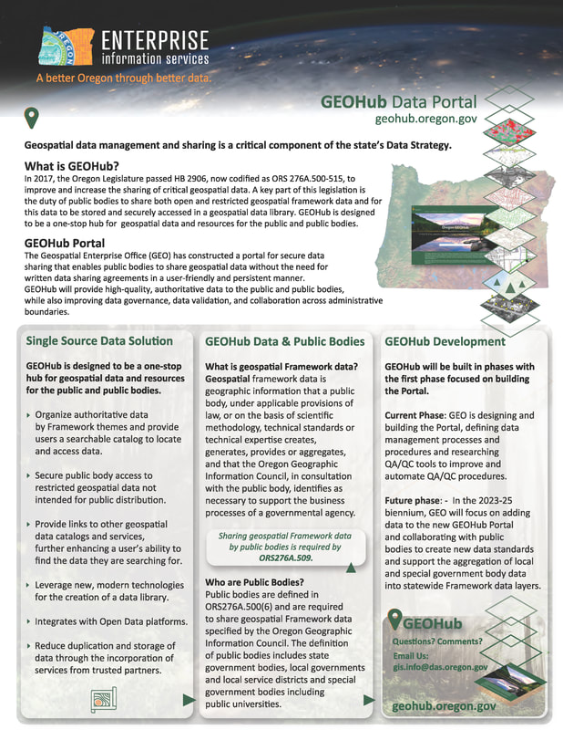 https://www.governmentjobs.com/careers/trimet/jobs/4095782/analyst-gis-data
Description The Geospatial Data Analyst is a technical position that provides geospatial analysis and support for agency-wide initiatives. This includes: queries and reports; support for desktop geospatial application development; training and software support; support for planning and decision making; data preparation, maintenance, and distribution at the agency-wide and regional level; technical documentation; and technical assistance where needed related to Geographic Information Systems (GIS) activity. This may also include: cartographic mapping and presentations; GPS data collection; feature editing; the development and documentation of user requirements and metadata; address standardization and geocoding; demographic analysis using Census data; programming and automation and cartographic design for presentation and analysis. This is a limited-term position with an end date of June 30, 2025. Ensure a commitment to safety through consistent and professional behaviors in performance of job requirements that demonstrate safety is a fundamental value that guides all aspects of our work. Perform related duties as required. Serve as a good steward of TriMet by regularly utilizing our transit system to maintain a strong and current understanding of customers’ experiences and of TriMet’s product and service offerings. Essential Functions
Position Requirements
*The amount of credit a candidate receives for prior years of experience is based on the relevancy of that experience to the required or preferred prerequisites of the job description. Experience is prorated based on hours worked. LRHR assigns and validates the "credited experience". Selection Criteria Type of Position / Grade / FLSA Grade 12, Exempt, Non-Union, Limited Term with end date of June 30, 2025. Salary Range Minimum: $66,925.00 Maximum: $100,385.00 Salary offers will be determined by a candidate’s education, training and relevant experience. Any final offer of employment will fall within the range stated above. For transparency, we choose to list the full available grade range, however, TriMet’s salary administration process will ultimately determine the final salary offered. Selection Process Candidates will be selected based at a minimum on the result of: 1. Application Review (please include: Cover Letter and Resume) 2. Panel Interviews 3. Reference Check Supplemental Information Make sure you describe in detail how your education, training and work experience fit with this role. You are encouraged to attach a resume, cover letter, training certificates and/or letters of recommendation with your application. You are permitted five attachments of less than 5MB each. https://jobs.masstransitmag.com/job/transit-gis-analyst-planner/
Overview Jarrett Walker + Associates (JWA) is excited to announce our next round of hiring, beginning today! JWA is seeking planners, data analysts, and cartographers with interest or experience in public transit to work in either Arlington, VA or Portland, OR. You must be close enough to commute to one of these offices on a regular basis. However, we continue to offer flexibility on which and how many days employees should be in the office, and most of our employees perform substantial parts of their work remotely. The position offers the potential to develop a range of transit planning skills. As a small firm, we can promote staff in response to skill and achievement. Everyone pitches in at many different levels, and there are many opportunities to learn on the job. Duties include a wide range of data analysis, mapping, graphic design and/or writing tasks associated with public transit planning. Salary range: $55,000 – $85,000 per year, plus benefits How to apply: Please submit applications via email to [email protected] . On the subject line please write “Analyst/Planner position.” Jarrett Walker + Associates is a consulting firm that helps communities think about public transit planning, especially the design of bus networks. We are solely focused on public transit planning and policy, and continually aspire to be the best in our field. Our goal in all our work is to foster clear conversations with the public and policy makers, leading to confident decisions. This means that we: • Begin with the values and priorities of each community. • Highlight the realities of the actual rider experience. • Show how geography and service impact the experience of marginalized communities, and identify ways to improve equity in service. • Bring to light the real trade-offs required to improve service in the context of how transit actually works. • Design legible networks that are easy to understand, and efficient to operate. Jarrett Walker & Associates is committed to fostering a culture of diversity, equity, and inclusion. We embrace and encourage our employees’ differences in age, color, disability, ethnicity, family or marital status, gender identity or expression, language, national origin, physical and mental ability, political affiliation, race, religion, sexual orientation, socio-economic status, veteran status, and other characteristics that make each person unique. We strive to maintain a workforce that reflects the diversity of the cities where we’re based, and that maximizes opportunities for racial minorities and women, who tend to be underrepresented in our profession. You can learn about us at our website (jarrettwalker.com) and at Jarrett’s blog (HumanTransit.org). Evaluation of Candidates When we evaluate candidates, we will look for a combination of analysis skills and instincts; cartography skills; transit planning interest or experience; and interpersonal/teamwork skills. We may ask candidates to complete a practical test. We will remove from applications information about each applicant’s sex, gender, race, ethnicity and name. Initial screening of applications will be performed without this information. You are encouraged to submit your material with your name and these other identifiers (sex, gender, race, ethnicity) omitted, and to provide your name only in the submittal email. If you do not do this our staff will do it for you. Compensation and Benefits Salary compensation will be based on experience, skill level, cost of living in your home area, and desired level of work. For a 40-hour per week position, annualized starting salary may range from $55,000 for an entry-level candidate meeting minimum requirements, up to $80,000 for a candidate with several years’ professional experience and several desired skills, abilities and experiences. Successful past hires have often received raises of 10% or more by the end of their first year of employment. Our benefits program includes: • Gold-level medical and dental insurance. • Disability insurance (short- and long-term). • A 401(k) program with employer contributions. • Paid medical leave, accrued at a rate of 1 hour per 30 hours worked, or about 8.5 days per year. • Paid time off starting at 19 days per year, with one additional day per year for each year of service. Paid time off includes both vacation time and holidays, but there are no restrictions on when it can be taken. • Very flexible work hours. Our staff work anywhere from 30 to 40 hours a week depending on their needs, and are compensated accordingly. We also have a flexible policy on unpaid leave, for employees who have used all their paid time off. • Flexible work location. New staff work in our office with us during a training period, but we offer flexibility on the specific days and times involved. • Employer-paid transit passes, or a monthly contribution to the costs of local transit fare, depending on your home area. • Reimbursement for application fees for the TSA PreCheck and Global Entry programs. Employees based in Oregon will also qualify for up to 12 weeks of paid family leave starting in September 2023, as part of the Paid Leave Oregon program. Growth and Development We generally prefer to develop staff internally rather than hire at senior levels, so there is considerable opportunity for strong employees to advance. All of our mid-level staff and one of our senior staff started in this position. The position offers the potential to develop a range of transit planning skills needed to advance in the profession. Everyone pitches in at many different levels, so there is intensive cross-training that helps everyone grow their skills. There are also opportunities for career development and to learn more advanced skills either on the job, through internal mentoring, or through attendance of professional conferences or other structured training. Diversity and Inclusion JWA follows an equal opportunity employment policy and employs personnel without regard to race, color, religion, sex/gender (including pregnancy, gender identity, and sexual orientation), national origin, age, disability, and any other legally protected status. This policy also applies to management of staff with regards to internal promotions, training, opportunities for advancement, and terminations. It also applies to our interactions with outside vendors, subcontractors, and the general public. Questions? As you consider whether to apply, please feel free to write to [email protected] with any questions you may have about the position. We aim to respond to every reasonable query. How to Apply To apply, please send the following materials to [email protected] by July 6, 2023: • 1-page cover letter explaining your interest in the position. • 1 or 2-page resume describing your relevant experience and skills – technical, planning, and interpersonal. Please include experience working on projects or in teams with people from different backgrounds. • Links or electronic files for up to three (3) samples of your work. If possible, please include a map, a piece of writing, and a demonstration of a spatial analysis. (A single sample may satisfy more than one of these requests.) o If you submit a university group project or other collaborative document with multiple authors that is not solely your work (i.e. government agency, nonprofit or consulting reports), please include a short note clarifying your role in the production of the document. For example, if you provide as a work sample a group project from a university course for which you designed all of the maps but were not the primary author of the text, please include a note saying so. • Contact information for 1 to 3 references who can attest to your experience with the skills listed above. Please do not include any information about your prior compensation. Do not put any information in the email itself that you want to be used in the evaluation. The cover letter and all other materials should be attachments. The email must present your name and contact details. Again, you are encouraged to anonymize all information by removing your name and references to sex, gender, race, or ethnicity, and to provide your name only in the email. If you do not, we will do this for you. Responsibilities What does a typical day look like? At JWA, analysts work on many different aspects of transit planning projects, using different tools and skillsets. For example, early on in a project, you could be asked to draw a map showing the frequency of each route in a transit network using Adobe Illustrator and QGIS. On another day, you might be asked to lay out a report in Adobe InDesign or create a set of charts in Excel or using R’s ggplot plotting package. Once you’re more experienced, you might spend time writing a technical memo or a chapter of a report, or make site visits to our clients in other cities to help with a design workshop or a public meeting. We also work together using R and other data analysis programming languages to conduct detailed analyses of existing transit service performance and compare different planning options. Because our team is small and our projects are highly varied, we seek to hire and provide training to ensure the widest range of ability possible among our staff. Required Skills and Experience For this position, the following are minimum requirements. • Two or more years professional experience using the skills listed in this section, or formal training in these skills (such as at a college or university). Directly applicable coursework is valuable but not essential. • Fluency in written and spoken English, particularly the ability to explain analytic ideas clearly. • Understanding and experience with analysis and visualization of quantitative or spatial information, including working with GIS. • Experience in cartography, evidenced in at least one mapping sample that is clear, accurate, and visually appealing. • Availability to start work no later than September 2023, at least 32 hours per week. • Willingness to travel occasionally (2-6 times per year) for projects. • Legal authorization to work in the US, or evidence of your ability to obtain such authorization without requiring employer sponsorship, as of the planned date of hire. In addition, the following knowledge, skills, abilities and experiences would also be desirable: • Knowledge and experience of a data analysis programming language, especially R. • Familiarity and experience using Adobe Illustrator and InDesign. • Knowledge and experience of advanced usage of Microsoft Excel. • Previous academic, work or volunteer experience related to public transit. ODFW’s Natural Resources Information Management Program is recruiting for a permanent Private Forest Accord, Fish Passage Barrier GIS Analyst ISS-5 position. Please see the following links for additional details:
State employees: Information Systems Specialist 5 (GIS Analyst) External applicants: Information Systems Specialist 5 (GIS Analyst) Job Description: Make a Difference in Oregon's Natural Resources! Help the Oregon Department of Fish and Wildlife fulfill its mission: To protect and enhance Oregon's fish and wildlife and their habitats for use and enjoyment by present and future generations. Do you have advanced skills in Esri ArcGIS Software? Do you want to make a valuable contribution to conserving Oregon’s fish and wildlife? This position will support the transfer of responsibilities, from the Oregon Dept. of Forestry (ODF) to ODFW, for determining and managing stream classification information with an emphasis on development of fish passage barrier data. Do you enjoy using your GIS and collaboration/coordination skills to build an emerging effort from the ground up? If so, we are looking to fill a permanent GIS Analyst position at our Headquarters office in Salem. The work of this role may be conducted remotely with full access to the needed operating systems and technology via a hybrid work schedule contingent upon business needs. This announcement will remain open until August 31, 2023 however we will begin reviewing applications at 8:00 am on Monday, July 10, 2023 and may close the announcement at anytime thereafter. If you enjoy the outdoors, Oregon’s Willamette Valley is the place for you. It is less than an hour from glaciated mountain peaks to the east, the Pacific Ocean to the west and the massive Columbia River Gorge to the north. You can fish 365 days a year, and there is hunting for big game, waterfowl and game birds. The Oregon coast attracts thousands of people who clam, crab and fish in the ocean for halibut, salmon and tuna. The outdoor opportunities are endless when it comes to fish and wildlife in Oregon! If culture is what you seek, the Willamette Valley is the most populated area in Oregon and contains its three largest cities: Salem, Portland and Eugene, which are home to many museums and theaters. The Valley is also known for its vineyards, breweries and fantastic casual dining experiences. To learn more about the department and the work we do, view the following video at https://myodfw.com/about to see examples of some of the maps we produce, please visit https://www.dfw.state.or.us/maps/index.asp What you will do:
The above statements are intended to describe the general nature and level of work being performed. They are not an exhaustive list of all responsibilities and duties required. Geographic Information System (GIS) Specialist - Portland, OR - #110568 - PORTLAND, OR, US, 97232
Date: Jun 24, 2023 Location: PORTLAND, OR, US, 97232 Company: PacifiCorp JOIN OUR TEAM PacifiCorp is seeking customer-centric candidates to grow and sustain our commitment to a culture of customer service excellence, environmental sustainability and diversity, equity and inclusion. General Purpose The GIS Specialist position ensures that As-Builts are mapped into the facility and GIS based connectivity mapping systems after construction completes. Will also provide support on various data clean-up projects. Responsible for updating the mapping and connectivity systems using redlines and other information that comes back from the field, engineering, or dispatch. Position requires a good understanding of electrical distribution systems or other utility network based systems in addition to a strong knowledge of distribution utility design and GIS fundamentals. Responsibilities • Use Geographic Information Systems (GIS), and custom applications to create, collect, compile, configure, transform, and maintain data that serves a variety of purposes. • Post map changes as instructed by field-completed drawings and as-builts. • Maintain complete records of the Company's distribution electrical assets. • Work to ensure departmental data quality and work productivity goals are met. • Maintain the electrical connectivity network within the GIS applications by ensuring complete network traceability from the substation to the end customer. • Generate maps; read and interpret electrical utility asset and connectivity maps to enter, edit, and update spatial and tabular data. • Maintain the accuracy of the GIS database(s) and technical files and documentation. • Work with design estimators and engineers to resolve design as-built connectivity discrepancies. • Coordinate with Operations managers, estimators, and service coordinators to resolve data issues. • Develop and maintain operational and procedural documentation. • Deliver accurate and timely resolution to daily production issues by troubleshooting and providing effective and timely solutions. • Interpret engineering designs, plans, plat maps and legal descriptions to automate, update, and correct map data; conduct mapping research in the field and office. • Complete digitizing, spatial data editing, attribute editing, data validation and maintenance of digital infrastructure spatial data and related attribute information. • Analyze data and perform QC/QA related activities, engineering standards enforcement, data validation, cartography, check plots, etc. • Prepare plans, material lists and drawings for both capital and maintenance work. • Prepare as-built drawings for emergency work and designs performed by third parties. • Perform queries against drawings to create specialty maps as requested. • Provide alternatives and recommendations to internal and external customers. • Assist with project driven data development and asset mapping projects. • Investigate and reconcile mapping discrepancies between retired mapping system and active mapping system. • Utilize productivity tools to efficiently navigate to and to edit features. Requirements
Preferences • Bachelor’s degree in Geographic Information System (GIS), Natural Resources, Geography or a related field; or the equivalent combination of education and experience. • Experience with and ArcGIS PRO • Experience with ArcFM • Knowledge of basic electrical distribution power systems • Understanding of utility connectivity • Experience with/understanding of electrical one lines, schematics, panel schedules, etc. Additional Information Req Id: 110568 Company Code: PacifiCorp Primary Location: PORTLAND Department: Pacific Power Schedule: Full-time Personnel Subarea: Non-Exempt Hiring Range: $59,100 - $69,500 Benefits: Health care, retirement, paid time off, tuition assistance, paid short-term and long-term disability, paid bereavement leave. For more information, please visit: https://careers.pacificorp.com/content/New-Benefits-Page/?locale=en_US Employees must be able to perform the essential functions of the position with or without an accommodation. At PacifiCorp, we celebrate diversity, equity and inclusion. PacifiCorp is proud to be an equal opportunity employer. All qualified applicants will receive consideration for employment without regard to race, color, religion or religious creed, age, national origin, ancestry, citizenship status (except as required by law), gender (including gender identity and expression), sex (including pregnancy), sexual orientation, genetic information, physical or mental disability, medical condition, veteran or military status, familial or parental status, marital status or any other category protected by applicable local, state or U.S. federal law. All offers of employment are contingent upon the successful completion of a background check and drug screening. Geographic Information System (GIS) Operations Manager - (Portland, OR) - #110105 - PORTLAND, OR, US, 97232
Date: Jun 23, 2023 Location: PORTLAND, OR, US, 97232 Company: PacifiCorp JOIN OUR TEAM!PacifiCorp is seeking customer-centric candidates to grow and sustain our commitment to a culture of customer service excellence, environmental sustainability and diversity, equity and inclusion. General Purpose The position reports to the Director of GIS, Mapping & Data Management and will be responsible for functional oversight of the day-to-day operations of a highly customer service driven GIS Solutions group. The GIS Solutions group manages and maintains geospatial data, performs related analysis and decision support, provides both services and products for diverse business units, and creates various web and mobile map-based applications. The GIS Operations Manager implements strategy and priorities developed by GIS Director. The GIS Operations Manager performs day to day management of staff and projects, leads and contributes to projects, and assists in establishing and implementing business objectives. Responsibilities
Req Id: 110105 Company Code: PacifiCorp Primary Location: Salt Lake City, UT or Portland, OR Department: Pacific Power Schedule: Full-time Personnel Subarea: Exempt Hiring Range: $113,100 - $133,000 This position is eligible for an annual discretionary performance incentive bonus of up to 15.00% of salary. Benefits: Health care, retirement, paid time off, tuition assistance, paid short-term and long-term disability, paid bereavement leave. For more information, please visit: https://careers.pacificorp.com/content/New-Benefits-Page/?locale=en_US Description
Several positions are available to support data entry and species occurrence mapping at the California Natural Diversity Database. See job ads for more details and for information on how to apply. CNDDB Assistant I (data entry/transcribing), [https://www.csuchico.edu/cse/_assets/documents/hr-jobs/id-983.pdf](https://gcc02.safelinks.protection.outlook.com/?url=https%3A%2F%2Fwww.csuchico.edu%2Fcse%2F_assets%2Fdocuments%2Fhr-jobs%2Fid-983.pdf&data=05%7C01%7CMelanie.Gogol-Prokurat%40wildlife.ca.gov%7Cf7a9a68618ca4b2e24d708db6d1f1a82%7C4b633c25efbf40069f1507442ba7aa0b%7C0%7C0%7C638223752576425882%7CUnknown%7CTWFpbGZsb3d8eyJWIjoiMC4wLjAwMDAiLCJQIjoiV2luMzIiLCJBTiI6Ik1haWwiLCJXVCI6Mn0%3D%7C3000%7C%7C%7C&sdata=Od5m0LzR0KKTd8WcQh7EfO6bVe4PYDgOW7Ja1wIfvYs%3D&reserved=0) - CNDDB Assistant I (working with single-species datasets), [https://www.csuchico.edu/cse/_assets/documents/hr-jobs/id-984.pdf](https://gcc02.safelinks.protection.outlook.com/?url=https%3A%2F%2Fwww.csuchico.edu%2Fcse%2F_assets%2Fdocuments%2Fhr-jobs%2Fid-984.pdf&data=05%7C01%7CMelanie.Gogol-Prokurat%40wildlife.ca.gov%7Cf7a9a68618ca4b2e24d708db6d1f1a82%7C4b633c25efbf40069f1507442ba7aa0b%7C0%7C0%7C638223752576425882%7CUnknown%7CTWFpbGZsb3d8eyJWIjoiMC4wLjAwMDAiLCJQIjoiV2luMzIiLCJBTiI6Ik1haWwiLCJXVCI6Mn0%3D%7C3000%7C%7C%7C&sdata=BQLep4z2PmtYrrY95UznnIr7Sr3utWNo5%2FRD7P25mI8%3D&reserved=0) - CNDDB Assistant I (zoology sourcer), [https://www.csuchico.edu/cse/_assets/documents/hr-jobs/id-985.pdf](https://gcc02.safelinks.protection.outlook.com/?url=https%3A%2F%2Fwww.csuchico.edu%2Fcse%2F_assets%2Fdocuments%2Fhr-jobs%2Fid-985.pdf&data=05%7C01%7CMelanie.Gogol-Prokurat%40wildlife.ca.gov%7Cf7a9a68618ca4b2e24d708db6d1f1a82%7C4b633c25efbf40069f1507442ba7aa0b%7C0%7C0%7C638223752576425882%7CUnknown%7CTWFpbGZsb3d8eyJWIjoiMC4wLjAwMDAiLCJQIjoiV2luMzIiLCJBTiI6Ik1haWwiLCJXVCI6Mn0%3D%7C3000%7C%7C%7C&sdata=IMlX0R1wKYmnEOC7bBUk2cvnwydQEDHkFQhwpmOxodc%3D&reserved=0) - CNDDB Assistant I (data acquisition for zoology and botany), [https://www.csuchico.edu/cse/_assets/documents/hr-jobs/id-984.pdf](https://gcc02.safelinks.protection.outlook.com/?url=https%3A%2F%2Fwww.csuchico.edu%2Fcse%2F_assets%2Fdocuments%2Fhr-jobs%2Fid-984.pdf&data=05%7C01%7CMelanie.Gogol-Prokurat%40wildlife.ca.gov%7Cf7a9a68618ca4b2e24d708db6d1f1a82%7C4b633c25efbf40069f1507442ba7aa0b%7C0%7C0%7C638223752576425882%7CUnknown%7CTWFpbGZsb3d8eyJWIjoiMC4wLjAwMDAiLCJQIjoiV2luMzIiLCJBTiI6Ik1haWwiLCJXVCI6Mn0%3D%7C3000%7C%7C%7C&sdata=BQLep4z2PmtYrrY95UznnIr7Sr3utWNo5%2FRD7P25mI8%3D&reserved=0) - CNDDB Rare Species Specialist (zoology ranking), [https://www.csuchico.edu/cse/_assets/documents/hr-jobs/id-986.pdf](https://gcc02.safelinks.protection.outlook.com/?url=https%3A%2F%2Fwww.csuchico.edu%2Fcse%2F_assets%2Fdocuments%2Fhr-jobs%2Fid-986.pdf&data=05%7C01%7CMelanie.Gogol-Prokurat%40wildlife.ca.gov%7Cf7a9a68618ca4b2e24d708db6d1f1a82%7C4b633c25efbf40069f1507442ba7aa0b%7C0%7C0%7C638223752576425882%7CUnknown%7CTWFpbGZsb3d8eyJWIjoiMC4wLjAwMDAiLCJQIjoiV2luMzIiLCJBTiI6Ik1haWwiLCJXVCI6Mn0%3D%7C3000%7C%7C%7C&sdata=xjN29Gpo4eGOmlhHkAggQ%2BNVtfezS%2BQyfgvsH7lbVFM%3D&reserved=0) About Organization Chico State Enterprises (CSE) provides specialized business services to support innovative research programs, community partnerships, entrepreneurial projects and other education-related activities funded by public and private grants or contracts, and led by faculty and associates of California State University, Chico. [https://www.csuchico.edu/cse](https://www.csuchico.edu/cse) The mission of the California Department of Fish and Wildlife (CDFW) is to manage California's diverse fish, wildlife, and plant resources, and the habitats upon which they depend, for their ecological values and for their use and enjoyment by the public. Closing date: 2023-07-12
Position: Project Manager - Ecological Modeling Organization: Chico State Enterprises and California Department of Fish and Wildlife Country: United States State: California Contact: Melanie Gogol-Prokurat Contact Email: [email protected] Description Join a team working on projects supporting the mapping and analysis of wildlife, habitats, and vegetation in California at the California Department of Fish and Wildlife, Biogeographic Data Branch! The positions will work closely with Ecologists and GIS Specialists in the Conservation Analysis Unit (CAU) and Vegetation Classification and Mapping Program (VegCAMP), and will focus on two different projects: - development of species ranges and species distribution models, with a focus on species of conservation concern. - development of spatial vegetation data, with a focus on sensitive natural communities. Expected start date is September 1. See the job ad below for more detail and for information on how to apply. https://www.csuchico.edu/cse/_assets/documents/hr-jobs/id-990.pdf](https://gcc02.safelinks.protection.outlook.com/?url=https%3A%2F%2Fwww.csuchico.edu%2Fcse%2F_assets%2Fdocuments%2Fhr-jobs%2Fid-990.pdf&data=05%7C01%7CMelanie.Gogol-Prokurat%40wildlife.ca.gov%7C82e2e9bc5b5b4036c0a108db740ebb3f%7C4b633c25efbf40069f1507442ba7aa0b%7C0%7C0%7C638231378851058501%7CUnknown%7CTWFpbGZsb3d8eyJWIjoiMC4wLjAwMDAiLCJQIjoiV2luMzIiLCJBTiI6Ik1haWwiLCJXVCI6Mn0%3D%7C3000%7C%7C%7C&sdata=uu2pOXhdXHsQwc%2Fcvif4JF1nXteHoatNJTQWS5U07uk%3D&reserved=0) About Organization Chico State Enterprises (CSE) provides specialized business services to support innovative research programs, community partnerships, entrepreneurial projects and other education-related activities funded by public and private grants or contracts, and led by faculty and associates of California State University, Chico. https://www.csuchico.edu/cse The mission of the California Department of Fish and Wildlife (CDFW) is to manage California's diverse fish, wildlife, and plant resources, and the habitats upon which they depend, for their ecological values and for their use and enjoyment by the public. https://www.governmentjobs.com/careers/hillsboro/jobs/4083000/gis-analyst
The Role This is an excellent opportunity for a qualified candidate to join an organization with a well-established and continuously evolving Enterprise GIS. We are seeking individuals who possess a strong inclination for creative problem-solving, a genuine passion for all things geospatial, and a collaborative mindset to contribute to administering and maintaining, and continuously advancing our Enterprise GIS. As a GIS Analyst, you will provide support for the City's Enterprise GIS, encompassing system architecture, data management, application development, system integrations, and more. Currently, the Information Services GIS team is undergoing a Geospatial Strategic Planning process that will shape the future growth of the City's GIS over the next 3-5 years. Projects will span a wide range, including web application design, system integrations, office and field work, extensive data analysis, real-time solutions, automation, and project management. If you are a seasoned GIS professional with expertise in ArcGIS Enterprise, VertiGIS products, and data management including working with real-time data, this opportunity could be a perfect match for you. We are seeking individuals who are not only experienced but also deeply passionate about GIS. The Ideal Candidate The ideal candidate for this position should have a strong foundation in Geographic Information System principles, practices, and concepts, backed by 3-5 years of relevant experience. It would be beneficial if you have a combination of expertise in Web GIS, real-time data, and/or experience with migrating to ESRI Utility Network. As you will be involved in various GIS tasks and collaborating with neighboring jurisdictions at the local, county, and state levels, possessing a can-do attitude, maintaining a sense of humor, and effectively collaborating with stakeholders are key qualities that will contribute to success in this role. Current Projects for this Position:
Licensing/Certifications Valid driver’s license and safe driving record Additional Information Bilingual incentive pay available Employees who can demonstrate the ability to speak Spanish, or any language spoken by over ten percent (10%) of City residents as documented by the most recent U.S. Census, at a proficiency level determined by a fluency test administered by the City, will receive a monthly premium of three percent (3%) of their regular base pay. Commitment to Diversity, Equity & Inclusion Hiring a workforce that reflects the diverse community we serve is essential to delivering exceptional City services and programs. The City of Hillsboro is committed to creating and supporting an inclusive and welcoming environment for all employees to thrive. We value, respect, and empower employees as unique individuals with authentic voices and diverse ideas. The City of Hillsboro recognizes that some applicants, particularly women, people with disabilities, and people of color do not always apply for positions unless they directly meet all of the qualifications. We greatly encourage you to apply and welcome applicants from diverse and varied backgrounds. Transferable skills WILL be considered when reviewing applications for meeting minimum qualifications. Engineering Technician 1 - Survey
Apply Portland, OR Full time Posted 13 Days Ago job requisition idR-11719 Current employees: Please apply through the employee portal to be considered for this opportunity. Pay Range: $26.99 - $33.08 Hourly Department: Department of Community Services (DCS) Job Type: Regular Closing Date (Open Until Filled if No Date Specified): July 04, 2023 The Opportunity: *only apply for this position once* OVERVIEW: This work matters! The Department of Community Services, Survey Section is looking for a full-time Engineering Technician 1! As part of the Department of Community Services, the Multnomah County Survey Section is responsible for, among other things, restoring and maintaining Public Land Corners; reviewing, filing and indexing work submitted by land surveyors; and providing survey support for capital improvement and other county projects. We are seeking an entry level survey technician to work primarily in the field. We are looking for candidates with the ability to work in a highly flexible, team-oriented environment that have exceptional communication, analytical and organizational skills. Your main duties will include:
Who Are We? Our department’s mission is to preserve harmony between natural and built environments, keep people and pets safe, and ensure every voice is heard through a diverse group of programs including transportation, land use planning, animal services, elections, and budget and operations support. This department is an incredibly diverse department and your role will be too. What We Can Offer You: DCS comprises unique and essential government services, including Elections, Land Use Planning, Animal Services and Transportation. The common mission of these diverse lines of business is articulated in this very simple statement: Inclusive community. Accessible services. So, with us, you will be challenged, you will be encouraged to excel, you will be given the opportunity to build a rewarding career. You will become a part of a strong organization dedicated to providing outstanding services to the community. At Multnomah County we are committed to maintaining an effective, respectful and inclusive workplace. We value collaborative problem solving and strive for continuous improvement. We strongly believe in workforce equity, diversity and inclusion. Visit our Workforce Equity Strategies Plan (WESP) to see where Multnomah County is headed with these values. This recruitment will be used to fill any current and future full-time, part-time, on-call, temporary and limited duration positions while the eligible for hire list is active. TO QUALIFY: We will consider any combination of relevant work experience, volunteering, education, and transferable skills as qualifying unless an item or section is labeled required. Please be clear and specific about how your background is relevant. For details about how we typically screen applications, review our overview of the selection process page. Minimum Qualifications/Transferable Skills*:
Preferred Qualifications/Transferable Skills*: You do not need to have the following preferred qualifications/transferable skills to qualify. However, keep in mind we may consider some or all of the following when identifying the most qualified candidates. Please clearly explain on your application how you meet any of the following preferred qualifications/transferable skills.
*Transferable skills: Your transferable skills are any skills you have gained through education, work experience (including the military) or life experience that are relevant for this position. Be sure to describe any transferable skills on your application and clearly explain how they apply to this position. SCREENING AND EVALUATION: The Application Packet: Please be sure to provide all the materials below in your application submission: 1. Online application: Explain all related experience (paid or unpaid) and training in the education and work experience sections of the application. 2. Attach a resume: Please indicate how you meet the required minimum qualifications. Attach the PDF document to the on-line application. Be sure to explain in detail, including dates, all related work experience, paid or unpaid. 3. A cover letter (optional): This should expand on your resume, address why you are interested in this position and demonstrate how your experience and skill set align with the minimum and preferred qualifications listed. Note: The application, resume, and cover letter should clearly demonstrate your work experience/skills and how they relate to the descriptions provided in the ‘Overview’ and ‘To Qualify’ sections of this job posting. Please be thorough, as these materials will be used to determine your eligibility for an interview. Internal candidates: After you have applied, you will receive the Oregon Veteran Preference Questionnaire in your Workday inbox. Your application as an internal candidate is not complete until you fill out and submit the Oregon Veteran Preference Questionnaire. The Selection Process: For details about how we typically screen applications, review our overview of the selection process page. We expect to evaluate candidates for this recruitment as follows: 1. Initial review of minimum qualifications 2. Evaluation of application materials to identify the most qualified candidates 3. Consideration of top candidates, which may include phone interviews, panel interviews, and/or additional testing 4. Professional reference checks Note: Application information may be used throughout the entire selection process. This process is subject to change without notice. ADDITIONAL INFORMATION: Type of Position: This hourly, union-represented position is eligible for overtime. Schedule: Monday-Thursday, 7:30 am - 5:00 pm, every other Friday, 7:30 am - 4:00 pm (9/80 schedule) Location: 1600 SE 190th Avenue, Portland, OR 97233 Diversity and Inclusion: At Multnomah County, we don't just accept difference; we value it and support it to create a culture of dignity and respect for our employees. We are proud to be an Equal Opportunity Employer. We evaluate qualified applicants without regard to race, color, religion, sex, sexual orientation, gender identity, national origin, disability, veteran or protected veteran status, genetic information and other legally protected characteristics. The EEO Know Your Rights poster is available for your reference. Multnomah County is a VEVRAA Federal Contractor. We request priority protected veteran referrals. Veterans’ Preference: Under Oregon Law, qualifying veterans may apply for veterans’ preference. Review our veterans’ preference page for details about eligibility and how to apply. Accommodation under the Americans with Disabilities Act: We gladly provide reasonable accommodation to anyone whose specific disability prevents them from completing an application or participating in this recruitment process. Please contact the recruiter below in advance to request assistance. Individuals with hearing or speech impairments may contact the recruiter through the Telecommunications Relay Service by dialing 711. Questions? Recruiter: Vlad MirkoEmail: [email protected] Phone: +1 (503) 3184861 |
Categories
All
Archives
June 2024
|
 RSS Feed