|
https://usaconservation.applicantpool.com/jobs/1118489.html
Summary American Conservation Experience, a nonprofit Conservation Corps, in partnership with the U.S. Fish and Wildlife Service (FWS), is seeking one GIS support member to contribute to geospatial data creation, data and records management, map creation and other related duties in support of the regional Division of Planning and Visitor Engagement. For more information about ACE, please visit our usaconservation website. Start Date: September 2024 (flexible) Estimated End Date: September 2025 (52 weeks after start date) *a 52-week minimum commitment is required, approximately 2080 hours* Location Details/Description: Remote. The GIS support member will work from their own home/space. Applicants local to the Southeast Region (NC, SC, GA, FL, AL, TN, KY, AR, LA, MS) will be given preference, as occasional travel to the Regional office in Atlanta, GA or other offices may be required. For more information about the USFWS Regional Office, please visit the USFWS website. Position Overview: The mission of the U.S. Fish and Wildlife Service (FWS) is working with others to conserve, protect, and enhance fish, wildlife, plants, and their habitats for the continuing benefit of the American people. This position will help FWS realize that mission at the Southeast Regional Office. The Member will primarily assist USFWS Regional Office employees (regional NWRS Planners and Visitor Services staff as well as field staff) with projects at national wildlife refuges across the Southeast Region. In accordance with Service policy, the Member will create, update and manage geospatial data, cartographic products, and additional project files as needed. The primary focus will be on providing geospatial support for regional NWRS Planning projects, such as Habitat Management plans, Land Acquisition plans, and Hunt and Fish plans. The Member will also provide additional project support to Visitor Services (up to 30% of their time). Visitor Services (VS) projects may include updating maps for public brochures, improving VS-related GIS data, and ensuring data is attributed correctly for display in the Drupal environment. Attention to detail will be critical. The Member will coordinate with various technical specialists, support personnel, and refuge staff to ensure that all requirements relating to data management are satisfactorily addressed and that the final geospatial products are managed and archived in accordance with Service and DOI policies. The Member will be responsible for documenting project processes, including writing policy-compliant metadata and standard operating procedure documents when applicable. The Member will also develop briefing materials and provide needed briefing materials for the Regional Planning team, project partners and others in the Regional Office. Deliverables include updating FWS Authoritative data layers (ADLs), project maps and accompanying data, ensuring all project files are managed in accordance with Service standards. Assist refuge managers and staff with guidance on updating ADLs. Participation in weekly planning conference calls and monthly Division calls to report progress and discuss obstacles in completing the tasks. This individual placement is meant to facilitate professional development and promotes exposure to land management agencies and networking with professionals. This could include gaining experience in different conservation fields and shadowing different work groups. Schedule: Duties will primarily be carried out Monday - Friday. Bi-weekly totals should not exceed 80 hours. A flexible work schedule may be required, which could involve work performed outside of normal work hours including on weekends and/or holidays. Time off may be granted and requests should be directed to ACE and the FWS for approval. Position Benefits Living Allowance: The ACE Member is expected to contribute ~40 hours/week and will receive a living allowance of $940/week to offset the costs of food and incidental expenses, dispersed bi-weekly. Public Land Corps Hiring Authority: Members serving under this agreement may be eligible for a federal hiring authority upon completion of their term of service and 640 hours of service. If the duration of a PLC-eligible term is not long enough for Members to accrue 640 hours of service (~16 weeks), the total hours served at the completion of the term may be eligible to be combined with hours accrued from another PLC-eligible term to meet the 640 hours requirement. PLC projects also include specific eligibility requirements such as age and citizenship. Please contact ACE staff with questions about eligibility, or view general information online at the usaconservation website. Housing: Housing is the responsibility of the member and not provided by ACE or FWS. Gear Reimbursement: ACE members will have up to $200 to spend on eligible gear purchases. Eligible gear for this position includes, an external monitor, keyboard or mouse, computer hubs or stations, external hard drive, or other related electronic or home office needs, and must be approved by ACE staff prior to purchase. Provided Training/Orientation: ACE members will receive position specific training and an orientation outlining ACE policies and procedures, clear guidance on prohibited activities, and networks for support. Specific training may include mandatory FWS IT security training, applicable FWS data and records management training, and ESRI virtual training (as-needed). Scholarship Funding Opportunity: The selected candidate(s) for this position will be eligible to apply for ACE's Access and Inclusion Scholarship. This is a $500 scholarship which is intended to make participation in ACE positions more accessible to individuals who are underrepresented in the conservation field. Scholarship recipients will be able to allocate this funding to financial need(s) of their choosing. A limited number of scholarships are available. https://conservation-legacy.breezy.hr/p/64d30ec3ce0b-gis-assistant
POSITION DETAILS Position Title: GIS Assistant Park Unit: Hawaii Volcanoes National Park Location: Hawaii National Park, Hawaii Number of positions available: 1 Can this position be fully remote: NO INTERNSHIP DATES AND LENGTH Duration: 20 Weeks (not flexible) Start Date: 10/14/2024 Flexible Start Date: YES LIVING AND RELOCATION ALLOWANCE: Weekly Stipend: $565.00 Relocation Allowance: $1,050.00 CURRENT NUMBER OF APPLICANTS: Under 75 (This posting will close after receiving 75 complete applications or at 11:59 p.m. EDT on Sunday, 16 June, whichever occurs first.) POSITION DESCRIPTION Hawai’i Volcanoes National Park (HAVO) is recruiting an intern to assist with GIS duties for the Natural Resources Management (NRM). The NRM program is comprised of native and non-native wildlife management, vegetation management, and restoration programs. Major duties include 1) transitioning natural resources data collection procedures from written field forms to digital data collection, 2) developing data quality assurance and control procedures associated with field data collection, 3) compatibility testing of digital data collection procedures in association with hardware and software programs currently utilized (e.g. mobile devices, ArcGIS Field Maps, ArcGIS Online), 4) Assisting with natural resources management fieldwork and/or field testing digital data collection procedures, 5) entering data into project databases and checking the quality of the data entered. Important responsibilities of this position include ensuring a respectful working environment, safely conducting work in a remote and physically challenging backcountry environment, collecting field data in a neat and complete manner, and communicating effectively with supervisors and crewmembers. https://www.governmentjobs.com/careers/thprd/jobs/3890987/diversify-internship?page=2&pagetype=jobOpportunitiesJobs
Are you an outgoing Black, Indigenous, and/or a Person of Color (BIPOC) student with a passion for public service? If so, a great paid internship opportunity may be waiting for you at Tualatin Hills Park & Recreation District (THPRD)! The Diversify Program is accepting applications for interns that will start after July 1, 2023. THPRD is committed to welcoming and including employees of all backgrounds and identities, and we are proud to offer opportunities that explore a variety of career possibilities within the field of parks and recreation. As part of our commitment to the community and based on park and recreations' historic underrepresentation of communities of color, this internship program is intended for students who identify as Black, Indigenous, and/or a Person of Color. We provide exciting internship opportunities in a variety of program areas within the district, including: Community Gardens, Community Outreach, Fitness & Exercise, Science, GIS, Human Resources, Landscape Architecture, Landscape Maintenance, Multimedia, Nature Education, Preschool, Recreation & Sports, Therapeutic Recreation, Trail Accessibility & Inclusion Click here to learn more about this opportunity and to view the full job description. These internships are budgeted for 10 – 16 weeks and schedules can vary from 15 – 40 hours per week. The district will work with interns to develop a schedule that works around their current class schedule. Hours will vary depending on the program’s needs and may include weekend days and evenings. Part-time employees are scheduled variable hours and may work less than 1,560 hours per year. Candidates are required to be enrolled, have been enrolled in the past year, or plan to enroll in the next year in a college-level class, certificate, or degree program. Typical job duties vary based on the program area and include both administrative and field experience interacting with patrons to:
Interns in this position will work with a supervisor to collaboratively identify steps to complete the project that fit both the intern’s goals and the district’s needs. Interns will also gain experience working with cross-district employees while contributing to a positive and inclusive experience for community members. The district also provides a bilingual pay incentive to paid interns who regularly use their bilingual or multilingual skills! Previous experience in the focus area is desired, but not required. Successful candidates will have a basic understanding of software and computer operations, written and verbal communication, basic math, and an interest in fitness and/or recreation. THPRD is committed to the full inclusion of all qualified individuals. As part of this commitment, THPRD will ensure that people experiencing disabilities are provided reasonable accommodations. If a reasonable accommodation is needed to participate in the job application or interview process, to perform essential job functions, and/or to receive other benefits and privileges of employment, please contact Human Resources at [email protected]. https://www.governmentjobs.com/careers/portlandor/jobs/4429889/bes-student-internship-program-strategy-integrated-planning
Job Appointment: Casual, Part-Time Work Schedule: Flexible hours between 8:00 AM and 5:00 PM; part-time and full-time opportunities available. Work Location: 1120 SW 5th Ave, Portland, OR 97204 Benefits: These positions are not eligible for benefits. Language Pay Differential: Employees who speak one or more languages in addition to English and who use their language skill to assist the community, may receive additional pay. More about the process can be found here. Application Material: Please click APPLY to submit your application via the City of Portland’s online portal. You will need to submit a work history and answer supplemental questions for this application. Note: These are casual Community Service Aide (CSA II) positions with a maximum of 1,400 hours in a calendar year. The internship areas of focus are:
Risk Assessment The Systems Analysis and Modeling Support section of the Risk Assessment Division performs engineering/modeling analysis to identify system deficiencies and provide optimal solutions to improve the City’s Combined sewer, Sanitary Sewer, and Stormwater systems. The Risk Assessment Intern will learn about:
These positions are not eligible for benefits. About the Bureau The Bureau of Environmental Services manages Portland's wastewater and stormwater infrastructure to protect public health and the environment. BES is a mission-driven, high-performance organization, leading the City in preserving and restoring the health of Portland's watersheds. More information about the Bureau: https://www.portlandoreoon.gov/bes/ Have a question? Contact Information: Cierra Maceo Recruiter [email protected] To Qualify
Additional Qualifications: Students who are pursuing:
The Recruitment Process STEP 1: Apply online between March 13, 2024 - April 26, 2024 Required Application Materials:
Step 2: Minimum Qualification Evaluation: Week of March 25, 2024, and bi-weekly thereafter
Step 3: Establishment of Eligible List: Eligible applicants will only be contacted for interviews.
Step 6: Start Date:
https://www.governmentjobs.com/careers/oregonmetro/jobs/4463065/gis-and-cartographic-intern
Position SummaryHello, we’re Metro! Metro is dedicated to shaping a better future for the greater Portland region. The work the people of Metro do every day benefits the lives of the people who live here, today, and tomorrow. Metro’s Planning, Development and Research department convenes people across the greater Portland region to think about the future of transportation and land use. Metro manages the boundary that separates urban land from rural land in the Portland region and works with communities to plan for future population growth and meet needs for housing, employment, transportation and recreation. This includes planning for major transit investments and supporting transit oriented development, local land use planning, community and economic development through grants and partnerships. Metro serves as the Metropolitan Planning Organization for the metropolitan area that includes Clackamas, Multnomah and Washington County. As an MPO, Metro works collaboratively with cities, counties and transportation agencies to decide how to invest federal highway and public transit funds within its service area. It creates a long-range transportation plan, leads efforts to expand the public transit system and helps make strategic use of a small subset of transportation funding that Congress sends directly to the MPO. Metro’s P,D&R department also serves as the regional clearinghouse for land information and coordinates data and research activities with government partners, academic institutions and the private sector. Metro's Research Center provides:
The Planning, Development & Research Department is looking for a GIS and Cartographic Intern to provide GIS, cartographic and visualization technique support to the Metropolitan Planning Organization (MPO) staff for the Portland metropolitan area. The intern will work closely with planning and public involvement staff. The intern will gain an understanding of regional transportation policies, project evaluation methods, the transportation funding process, as well as research, analysis, writing, graphic design, and public outreach skills. The ideal candidate is a person who is enthusiastic, dedicated, and eager to learn more about the transportation planning and funding fields. This position is open to graduate students or recent graduates seeking work experience in the field of planning and public administration. Candidates should have a bachelor’s or pursuing a master’s degree in public administration, planning, urban design, geography, or a related field. As the GIS and Cartographic Intern you will
DIVERSITY AND INCLUSION At Metro, we strive to cultivate diversity, advance equity, and practice inclusion in all of its work. This means attracting and empowering a workforce that is inclusive of a broad range of human qualities. Workplace diversity is both a moral imperative and a business strength, essential to providing quality support and services to our region. Metro’s goal is to hire, develop and retain highly skilled and talented individuals across all departments and programs who best reflect the diversity of our community. Learn more about Metro’s Diversity Action Plan TO QUALIFY We will consider any combination of relevant work experience, volunteering, education, and transferable skills as qualifying unless an item or section is labeled required. Please be clear and specific in your application materials on how your background is relevant. Minimum qualifications
If this statement is true for you, then you may be ineligible to apply If you were terminated for cause during any employment with Metro, or resigned in lieu of termination, you may be ineligible for rehire for a minimum of 3 years. Hybrid Telework At this time, this position is designated as “hybrid telework.” You will have the option to work away from the office, although there may be times that coming into the office will be required. The manager will work with you to identify a schedule that balances the operational needs of the department and your needs. Employees must reside in Oregon or Washington to work at Metro SCREENING AND EVALUATION The application packet: The application packet consists of the following required documents. Please ensure that you upload these documents in your online application. Make sure your application is complete, missing any part of these items could result in an incomplete application and will not be moved forward in the recruitment.
The selection process: We expect to evaluate candidates for this recruitment as follows. The selection process is subject to change.
COMPENSATION, BENEFITS AND REPRESENTATION The full-salary range for this position is step 1 $20.20 per hour to step 3 $24.00 per hour. However, unless a candidate’s qualifications justify, based on the Oregon Pay Equity Act requirements and Metro’s internal equity review process, the appointment will likely be made between Step 2 $22.00 per hour to the equity range Step 3 $24.00 per hour. This position is eligible for overtime and is non-represented. It is classified as an Intern. Classification descriptions are typically written broadly and do not include the specific duties and responsibilities of the positions. View the classification description. Questions? Recruiter: Lamarkus Gilliard Email: [email protected] The National Park Service, Alaska Region, just announced a 6-month (plus) internship opportunity to assist with GIS in support of a stream restoration project in Yukon-Charley Rivers National Preserve. See the attached announcement for details. Applications due by April 20. https://www.suu.edu/iic/internships/ 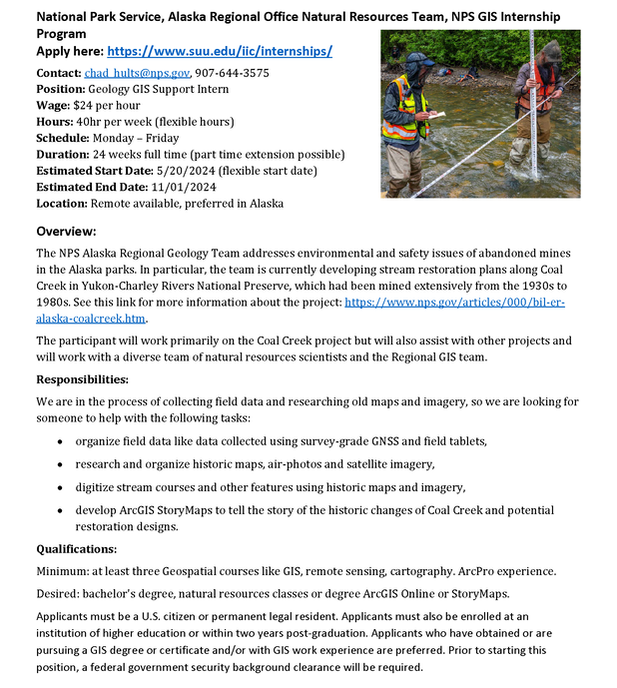 https://conservationdistrict.org/2024/new-weedwise-technician-2024.html
WeedWise Technician (Seasonal)The WeedWise Technician is a full-time, seasonal (1040 hours), at-will position that will assist with surveying and managing invasive weeds. Successful candidates will assist with WeedWise Program activities and initiatives as required. Successful applicants will demonstrate:
Additionally, successful applicants will have:
Purpose
Performs data collection and validation, supports initiatives of the Water, Sewer and Storm Comprehensive Plans and assists with Engineering Vault scanning and organization. Schedule/Duration: Up to forty (40) hours per week for a maximum of six (6) months. Qualification Requirements
City of Wenatchee Government The City of Wenatchee is a full-service City employing 190 employees. In addition to Information Technology, other departments include Public Works, Police, Parks, Recreation and Cultural Services, Finance, Human Resources and Community Development. The City operates under a Strong Mayor form of government with seven council members. Active boards and commissions advise the City Council with governance. The Community The City of Wenatchee is home to 35,405 people with 116,178 living in the greater Wenatchee area. Located in a beautiful valley at the confluence of the Wenatchee and Columbia Rivers and on the east slopes of the Cascade Mountain Range, the city enjoys abundant sunshine with four distinct seasons. The average rainfall is a mere 10 inches per year making the region a focal point of Washington State for outdoor recreation. Wenatchee is the largest city in rural North Central Washington and thus provides a small-town atmosphere with big city amenities striking a great balance between rural and urban qualities of life. Must See: “We Are Wenatchee Part I” https://vimeo.com/88411706 “We Are Wenatchee Part II” https://vimeo.com/121429638 “We Are Wenatchee Part III” https://vimeo.com/208608170 Our historic downtown is a nationally recognized Main Street with an active downtown association http://www.wenatcheedowntown.org. HOW TO APPLY To view the job description and complete an online application please visit: https://www.governmentjobs.com/careers/wenatcheewa. Initial Review Date: 5:00 P.M., Monday, April 15, 2024. Open Until Filled. https://careers-nv5.icims.com/jobs/9724/summer-intern/job
Overview NV5 is a global technology solutions and consulting services company with a workforce of over 4,500 professionals in more than 100 offices worldwide. NV5’s continued growth has been spurred through strategic investments in firms with unique capabilities to help current and future customers solve the world’s toughest problems. The NV5 family brings together talent across a wide range of markets and fields, including Professional Engineers, Professional Land Surveyors, Architects, Photogrammetrists, GIS Professionals, Software Developers, IT, Project Management Professionals, and more. At NV5 Geospatial, We are a collaboration of intelligent, innovative thinkers who care for each other, our communities, and the environment. We value both heart and head, the diversity of our people, and their experiences because that is how we continue to grow as a leader in our industry and expand our individual and collective potential. Interns will aid in the processing of remote sensing/GIS data, and general operational efforts, to support projects and team functionality. This individual will learn to produce accurate and precise data products in a consistent and timely manner and should have a strong interest in the geospatial field. The opportunity is meant to introduce them to geospatial production workflows, remote sensing technologies and tools, and provide on-the-job experience and professional skill building. Responsibilities Responsibilities:
Opportunities:
Knowledge, Skills, and Abilities:
Qualifications Minimum Qualifications:
Preferred Qualifications:
Please include a letter of interest, resume and a list of professional references in one document. NV5 offers a competitive compensation and benefits package including medical, dental, life insurance, PTO, 401(k) and professional development/advancement opportunities. Description:
We have funding for two paid interns to work with staff at Sunrise County Economic Council in collaboration with GMRI researchers and local partners. Interns will work on flood resilience mapping, citizen science efforts, and education and outreach activities. Most of the work will focus on Downeast coastal communities, but some projects may involve producing maps and other materials for Midcoast and Southern Maine communities that are also participating in the GMRI project. Time frame: Start date- Flexible, depending on intern availability End date- August 30th Compensation: Students will be employed through the University of Maine. Rates of pay will depend on whether the students are graduates or undergraduates. Affordable housing is available in the UMaine at Machias residence halls. Qualifications: Required: . Completion of least one college-level geographic information systems course. . Excellent written communication skills . Valid driver's license . Commitment to collaboration and community resilience Preferred: . Experience with ArcGIS Online and web-based map design . Experience with raster-based GIS flood modeling . Excellent visual communication skills . Basic understanding of climate-related coastal flood vulnerability . Familiarity with the Maine coast, especially the Downeast Region Work location: Interns may be able to work largely remotely, but some in-person activities will be required, so students must be in Maine for the summer. Affordable lodging is available in the UMaine at Machias residence halls. Downeast Maine offers spectacular surroundings and lots of opportunities for outdoor adventures hiking, boating, sightseeing, and more. Summers are cool and green and lovely, and fresh seafood and blueberries abound. It's a fantastic place to spend the summer. To apply, send cover letter, resume and a sample GIS project to: Tora Johnson [email protected] Any questions? Please contact Tora Johnson at [email protected]. ~~~~~~~~~~~~~~~~~ Tora Johnson, PhD (she/ her) Professor Emerita of GIS External Faculty Associate, Senator George J. Mitchell Center for Sustainability Solutions External Graduate Faculty, School of Forest Resources |
Categories
All
Archives
June 2024
|
 RSS Feed