CHRISTINA FRIEDLE

Geospatial Jobs, Internships, events, news & More

  • Home
  • About Me
  • Courses
  • GIS Club
    • About Us
    • Don't be a Dangle!
    • Event Calendar
  • Resources
    • Data
    • Tools
    • Blogs
    • ArcGIS Install
  • Blog
  • Aventuras Colombianas

2/24/2014

GIS Analyst w/ Coldwater Creek (ID)

0 Comments

Read Now
 
Picture
Job description
Use your passion of GIS technology together with your business acumen to help drive decisions of our retail store fleet. 

The GIS Analyst is responsible for providing geospatial analysis, mapping, and enhancement of our GIS systems in support of our company’s retail store needs.  You’ll develop and deliver results on a range of business analytics using a combination of GIS and business data.  

 Responsibilities  
  • Partner with the real estate team to establish market strategies and potential
  • Perform site location analysis in support of our retail store fleet
  • Leverage internal data and market knowledge to develop and refine geographic trade areas
  • Utilize MapInfo Professional and related databases to generate maps for use across the organization
  • Work with Real Estate and other business functions to gather requirements and subsequently design, develop, and deliver analytical solutions to understand key business behaviors
  • Provide demographic and psychographic analysis
  • Track and maintain ancillary data elements to support GIS processes
  • Help set the vision and strategic goals for GIS
  • Present findings to management
  • Provide ad-hoc analysis and reporting as needed


Desired Skills and Experience
  • B.S. Degree or certificate in Geographic Information systems, Business, or related field
  • A thorough understanding of geospatial concepts, cartographic principles, and spatial analysis.
  • Experience with MapInfo Professional or other GIS system
  • Experience with Microsoft SQL Server or other DBMS preferred
  • Prefer experience in a multi-channel retail environment
  • Detail-oriented and highly organized
  • Excellent communication and project management skills
  • A balance of technical acumen and business understanding
  • Creative problem solving
To apply: https://www.hirebridge.com/v3/application/Jobapplylogin.aspx?cid=6851&jid=231727


Share

0 Comments

2/24/2014

GIS Developer w/ Intera (Richland, WA)

0 Comments

Read Now
 
Picture
http://www.interacareers.com/jobDesc.asp?JobID=3
GIS Developer
 

Job Description
INTERA Incorporated is seeking qualified applicants for a GIS Analyst/Developer position in our Richland, Washington, office. This position develops, implements, and maintains complex GIS applications, including web-based systems. Supports the creation, maintenance, and usage of GIS data by both technical and non-technical users. Writes GIS software applications for delivery of various data types over multiple platforms. Maintains quality control and assurance and thorough documentation. Monitors system usage and provides hardware and software support as required.
 
Required Qualifications
  • Requires any combination of education and experience equivalent to at least Bachelor's degree (preference is a Master’s degree) in Geography, Geographic Information Systems, Computer Science, hydrogeology, environmental engineering or a related field.
  • The successful candidate must also have two to five years GIS experience with ArcGIS, ArcSDE, and SQL databases. 
  • Experience with Python programming preferred.
  • Experience with other programming languages such as Javascript and .net also desirable.
  • Some experience was project management is also preferred.
  • Background in water resources and environmental science preferred but not necessary.
  • Preference will be given to applicants with strong quantitative analyses skills. 
  • Excellent verbal and written communication skills are essential.

INTERA is an Equal Opportunity Employer.

Share

0 Comments

2/24/2014

2014 GIS In Action Conference - April 16 & 17

0 Comments

Read Now
 
Picture
April 16th & 17th, 2014
(Workshops April 15th)


Early Registration is NOW OPEN!  Click HERE to register.

Eight weeks until the Premier GIS conference in Oregon. 

Please mark your calendars for the TWENTY-SECOND  Annual GIS In Action Conference, hosted by the Columbia River Region of the American Society of Photogrammetry and Remote Sensing (ASPRS) and the Oregon-Southwest Washington Chapter of the Urban and Regional Information Systems Association (URISA). This year, we are back at Portland State University! Each year ASPRS and URISA collaborate to hold this informational conference on current issues in the Geospatial Information Community. Join us for what will surely be another successful opportunity to meet with colleagues in the geospatial industries and organizations, to learn about emerging topics and recent advances in GIS applications, and to discuss our problems and solutions together. Don’t miss this amazing opportunity to meet and network with GIS professionals from the region. Find out who is doing what, and how.

Preliminary Conference Program coming soon!

We have a new conference only web site.

Register now for the upcoming GIS in Action conference April 16 & 17, 2014 held at Portland State University. 

There are several pre-conference workshops being held on Tuesday, April 15th, the day before the conference. These workshops are all offered at a discount to conference attendees.  

Here is the list of workshops with detailed descriptions on the web site.
  • Working with Real-Time high precision GPS/GNSS in ESRI's mobile software (ArcPad and ArcGIS for Mobile)
  • Working with ModelBuilder
  • Programming ArcGIS 10.1 with Python
  • Cartographic Design in GIS
  • Working with US Census data

Call for posters!
Poetical Poster Contestants, 

Participants at the 2014 GIS in Action conference will have the opportunity to present a poster and engage in a competition, which includes prizes in different poster categories. Anyone going to the conference can enter to display their poster. Details for entry to the competition are below. You can enter a digital and/or paper version. The deadline to enter is the beginning of the conference.   

Voting will happen on all posters and winners will receive $50 REI gift certificates  for first place and $25 certificate for second place for five categories. 

If you plan to enter a poster please send an e-mail to postercontest.gisinaction@gmail.com.  

More information about the Posters is on the Program tab on our new web site.


Share

0 Comments

2/21/2014

Jarrett Walker + Associates is seeking a Junior Associate/GIS Analyst in Transit Planning. 

0 Comments

Read Now
 
Picture
The firm: 
JWA is a small and growing consulting firm (now with 3.25 FTE) based in Portland, Oregon.  Founded on the work of Jarrett Walker (see his book Human Transit and blog HumanTransit.org), our firm’s mission is to raise expectations for quality and clarity in studies and public discussions of transit planning. 
 
We offer our clients an innovative approach to transit planning, in which planning and policy 
thinking are integrated, and technical ideas are connected to the values that motivate people to 
care about transit. 
 
Projects we lead include transit network redesign studies, practical visioning workshops and 
service branding studies. 
 
The position: 
GIS analysis, map-making, and creating visual explanations are integral to nearly all of our 
work. Quantitative analysis, typically using Excel, is also important. We are seeking a talented 
and creative person to join our team as an Analyst at the Junior Associate level, to help us 
deliver great work to clients while continuing to innovate in our approach. 

For a full job description and application details: http://urbanist.typepad.com/files/jwa-jr.-associate-gis-analyst.pdf


Share

0 Comments

2/21/2014

Field Intern w/ Multnomah Soil & Water Conservation District

0 Comments

Read Now
 
Picture
West Multnomah Soil & Water Conservation District is hiring one limited-duration, at will, non-exempt, part-time Field Intern for the spring and summer of 2014 (approximately April  though September).  This internship is designed to provide experience in the areas of water quality, invasive species, habitat restoration, GIS, forestry and agricultural land uses.  

More details about the opportunity are attached and also posted on our website at: http://www.wmswcd.org/content.cfm/Who-We-Are/Employment-Opportunities


Share

0 Comments

2/18/2014

PSU Geospatial Information Society Colloquium: Friday, 21 Feb, 3:00-4:00 PM, Cramer Hall room 413

0 Comments

Read Now
 
Picture
The PSU Geospatial Information Society is hosting a colloquium next Friday, 21 Jan, from 3:00 to 4:00 PM in Cramer Hall room 413.

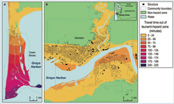
Our speaker will be Nathan Wood, a research geographer with the USGS. His presentation will focus on how GIS is being used to help plan the location of tsunami vertical-evacuation refuges in coastal areas subject to tsunami threat in the Pacific Northwest.

All are welcome, and we invite you to join us for this presentation. Please see the attached flyer for more information.

If you are an ASPRS member, please note that the ASPRS Columbia River Region Annual Dinner takes place later that same day.

Share

0 Comments

2/12/2014

Esri News for Students and Recent Graduates

0 Comments

Read Now
 
Picture
the latest issue of Esri News for Students and Recent Graduates is now available online:
http://www.esri.com/careers/students/career-newsletter

Included in this issue is information on summer programs (deadlines approaching!), careers for soon-to-be grads, GeoDev Meetups, and more.


Share

0 Comments

2/12/2014

Conservation GIS Happy Hour (February)

0 Comments

Read Now
 
We are heading back to the Horse Brass Pub on Belmont this month.

Tomorrow (2nd Wednesday of February)

4534 SE Belmont 

5:30 ish... 

Share

0 Comments

2/12/2014

Invasive Species GIS Internship (Vancouver, WA)

0 Comments

Read Now
 
Picture
Invasive Species GIS Internship
Clark Public Utilities – StreamTeam & Eradication Nation
Project Location:  8600 NE 117th Avenue, Vancouver, Washington
Start date: Position available part-time starting in late March/early April. Full-time start date flexible, May – October.

 The watershed enhancement program at Clark Public Utilities began in 1992 and has grown to become a regionally recognized environmental restoration effort.  Since the program’s inception, volunteers from a variety of backgrounds have planted over 740,000 native trees to bring salmon back to Salmon Creek.  Unfortunately a variety of non-native invasive plant species threaten these important riparian ecosystems.  

 The GIS Intern will support the Utilities’ Eradication Nation program. This program is focused on controlling invasive Japanese knotweed and other invasive plant species in the Salmon Creek watershed while engaging volunteers and landowners in the community.  The GIS Intern will assist with field activities such as knotweed surveys and control, but will primarily focus on managing and processing GPS data taken in the field. Compensation is dependent on college enrollment. Individuals who have just graduated will also be considered.

Primary Duties:
  • Manage GPS field data using ArcPad, DNR Garmin and ArcMap.
  • Create field maps for survey and treatment activities.
  • Manage GIS data to track progress and results.
  • Maintain detailed data records for knotweed surveys, treatment and monitoring.

Other Duties Include:
  • Ground-truth GPS data for a small number of sites on a regular basis.
  • Conduct knotweed surveys with staff and volunteers along streams and roads using GPS technology to map locations of infestations.
  • Conduct knotweed control activities with staff and volunteers including the application of herbicides during specified treatment windows.
  • Conduct follow-up monitoring activities for treated infestations.
  • Assist with outreach activities including: direct mailings, participation in community-wide events, and facilitating volunteer events.

The intern will have the opportunity to develop the following skills: invasive plant ecology, taxonomy and identification; invasive species management practices including survey and  treatment methods; and experience using programs such as Microsoft Excel, ArcGIS 10, ArcPad 10 and DNR Garmin. 

Position Requirements:
  • Regular and reliable attendance and commitment to the full duration of the internship (May-October).
  • Compensation is dependent on college enrollment. Individuals who have just graduated will also be considered. School attendance is not required during summer break.  
  • Dedication to environmental stewardship, passion for habitat restoration.
  • Willingness to work outside in all weather conditions for the entire work day. Roughly 0.5-2 days per week will be spent in the field on control activities and data collection during peak treatment season.
  • Communicate and interact in a positive, professional manner with a variety of individuals including teammates, staff, landowners, volunteers and the general public.
  • Willingness to use herbicides in invasive species control efforts, with training.
  • Physical ability to walk up to 5 miles per day on uneven terrain (including walking in-stream) and lift up to 40 lbs.
  • Primary work week is Tuesday through Friday; 7am-5:30pm.  Willingness to serve a flexible schedule, including some evenings and weekends (approximately 2-3 Saturdays or as determined by staff). Any evening or weekend hours would be for volunteer events and scheduled in advance.
  • Willingness and ability to drive vehicles such as passenger vans, utility vehicles and/or pick-up trucks with attached equipment trailers, with training.
  • Must have a valid driver's license, clean driving record and reliable transportation to and from work.
  • Ability to successfully pass a drug test (random or otherwise).
  • 18 years of age or older at the beginning of employment.
  • U.S. citizen, national or lawful permanent resident.
  • Possession of a high school diploma or equivalent.

Preferred Qualifications:
  • Experience with ArcGIS 10, ArcPad 10 and using Trimble and Garmin units to collect data in the field.
  • Natural resource or biology background preferred but not a requirement.
  • Strong organizational skills and self-initiative to prioritize multiple projects in order to meet deadlines.
  • Ability to effectively work independently and with teams
  • Strong interpersonal and customer service skills
  • Strong written and verbal communication skills, especially public speaking skills.

Work hours / internship duration:
Interns are expected to work a minimum of 40 hours per week during the summer months (June-September). Flex time will be given for weeks where interns are expected to work on Saturdays. 

Compensation:
Compensation is dependent on college enrollment. Individuals who have just graduated will also be considered. School attendance is not required during the summer break. $9.50 per hour to start; $10.50 after 520 hours. This is a non-benefited position. 

Submit cover letter, resume and references by March 1, 2014 to:
Bethany Lund, Invasive Species Program Coordinator, blund@clarkpud.com, 360 992 8787
Visit our website – www.streamteam.net, click on Eradication Nation for more information about the program.

Share

0 Comments

2/9/2014

GIS / CAD Technician (Mukilteo, WA)

0 Comments

Read Now
 
Picture
GIS / CAD Technician
City of Mukilteo
Mukilteo, WA


Job Description
The GIS Technician produces maps for all city departments, develops and maintains the city’s GIS database and coverages and gathers GPS data. Produces CAD drawings as needed for the Engineering Department. This is a shared position between the City of Mukilteo and other outside agencies. 

For full job description and application details: http://www.planning.org/jobs/search/listing/?AdID=47557

Share

0 Comments
<<Previous
Details

    Archives

    March 2023
    February 2023
    January 2023
    December 2022
    November 2022
    October 2022
    September 2022
    August 2022
    July 2022
    June 2022
    May 2022
    April 2022
    March 2022
    February 2022
    January 2022
    December 2021
    November 2021
    October 2021
    September 2021
    August 2021
    July 2021
    June 2021
    May 2021
    April 2021
    March 2021
    February 2021
    January 2021
    December 2020
    November 2020
    October 2020
    September 2020
    August 2020
    July 2020
    June 2020
    May 2020
    April 2020
    March 2020
    February 2020
    January 2020
    December 2019
    November 2019
    October 2019
    September 2019
    August 2019
    July 2019
    June 2019
    May 2019
    April 2019
    March 2019
    February 2019
    January 2019
    December 2018
    November 2018
    October 2018
    September 2018
    August 2018
    July 2018
    June 2018
    May 2018
    April 2018
    March 2018
    February 2018
    January 2018
    December 2017
    November 2017
    October 2017
    September 2017
    August 2017
    July 2017
    June 2017
    May 2017
    April 2017
    March 2017
    February 2017
    January 2017
    December 2016
    November 2016
    October 2016
    September 2016
    August 2016
    July 2016
    June 2016
    May 2016
    April 2016
    March 2016
    February 2016
    January 2016
    December 2015
    November 2015
    October 2015
    September 2015
    August 2015
    July 2015
    June 2015
    May 2015
    April 2015
    March 2015
    February 2015
    January 2015
    December 2014
    November 2014
    October 2014
    September 2014
    August 2014
    July 2014
    June 2014
    May 2014
    April 2014
    March 2014
    February 2014
    January 2014
    December 2013
    November 2013
    October 2013
    September 2013
    August 2013
    July 2013
    June 2013
    May 2013
    April 2013
    March 2013
    February 2013
    January 2013
    December 2012
    November 2012
    October 2012
    September 2012
    August 2012
    July 2012
    June 2012
    May 2012
    April 2012
    March 2012
    February 2012
    January 2012
    December 2011
    November 2011
    October 2011
    September 2011
    August 2011
    July 2011
    June 2011
    May 2011
    April 2011
    March 2011
    February 2011
    January 2011
    December 2010
    November 2010
    October 2010
    September 2010
    August 2010
    July 2010
    June 2010
    May 2010
    April 2010
    March 2010
    February 2010
    January 2010
    December 2009
    November 2009
    October 2009
    September 2009
    May 2009
    April 2009

    Categories

    All
    Aag
    Americorps
    Animations
    Applied GIS
    Applied Gis
    Apps
    Article
    Articles
    Asprs
    Books
    Careers
    Cartography
    Competition
    Conferences
    Conservation
    Diaster Mapping
    Drones
    Environmental
    Esri
    Events
    Fellowships
    Games
    Geoapp
    Geographic Awareness
    Geography
    Geomatics
    Geospatial Technologies
    GIS
    GIS Data
    Gis Data
    GIS Day
    GIS Day
    GIS Resources
    Gis-resources
    Google
    Google Earth
    Google Maps
    Gps
    Graduate School
    Grants
    Happy Hour
    Happy Hours
    Humor
    Hydrology
    International
    Internships
    Interviews
    Job
    Jobs
    Journals
    Lecture
    Lidar
    Maps
    Meeting
    National Geographic
    Natural Resources
    Open Source
    Oregon
    PCC
    Podcast
    Porland
    Portland
    Presentations
    Professional Development
    Professional-development
    Projections
    Raster
    Remote Sensing
    Research
    Scgis
    Scholarships
    Social Networks
    Software
    Songs
    STEM
    Story Maps
    Study Abroad
    Surveying
    Technical Help
    Tools
    Training
    UAS
    UAV
    University
    Urban Design
    Videos
    Visualization
    Webinar
    Web Mappping
    Websites
    Women In GIS
    Workshops

    RSS Feed

Contact ME

  • Home
  • About Me
  • Courses
  • GIS Club
    • About Us
    • Don't be a Dangle!
    • Event Calendar
  • Resources
    • Data
    • Tools
    • Blogs
    • ArcGIS Install
  • Blog
  • Aventuras Colombianas