|
Check out this interactive map put out by the NY Times that shows coastal and low-lying areas that would be flooded, without engineered protection, in three levels of higher seas.
http://www.nytimes.com/interactive/2012/11/24/opinion/sunday/what-could-disappear.html?ref=sunday City of Beaverton is hiring a temporary GIS Technician. The position pays $17.24hr / 40hrs per week and will last approximately 6 months. They would like to hire someone to start by 1/2/2013.
Duties to be Performed: This position will be responsible for updating GIS Data in the City of Beaverton’s GIS system. Qualified applicants will need to know how to geo-reference CAD and / or .Tiff files so that the data can edited into an enterprise SDE Geodatabase. Experience with versioning and multi user environments is desired but not required. Please e-mail Justin Manville directly if you are interested in this position. Juston Manville GIS Manager 4755 S.W. Griffith Dr Beaverton, OR 97076 Phone: (503) 350-4002 Fax: (503) 526-3720 E-Mail: [email protected] www.beavertonoregon.gov 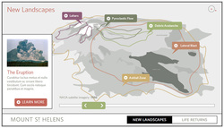 Second Story, a Portland based company that creates interactive experiences, is delving into the 3D mapping realm. They are creating an interactive 3D map of disturbance zones and vegetation at Mount St. Helens.
For the full blog post: http://blog.secondstory.com/chaos-opportunity#!/ The Oregon & SW Washington chapter of URISA is a non-profit organization dedicated to encouraging and advancing an interdisciplinary approach to developing urban and regional information systems. Providing scholarships to assist in the education of future professionals and advancing research in this discipline are two goals aimed at assisting in this endeavor. The scholarship consists of two awards – the Mark Bosworth Tuition Scholarship and a research grant.
The Mark Bosworth Tuition Scholarship is designed to help defray the costs of GIS courses. The degree or program the applicant is working towards does not have to be specifically for GIS; however, the student must have an emphasis or focus within the degree on GIS. The research scholarship is designed to facilitate research focusing on some aspect of GIS. The student can be pursuing a degree in any relevant field. For the full description: http://www.orurisa.org/Default.aspx?pageId=464265 Applications are dur on February 28, 2013 and should be submitted electronically. Click here for the applications: Tuition Scholarship Research Scholarship Oregon Environmental Council's Jennifer Coleman will be giving a brief lecture on "Pollution in People" at Portland Community College. This event is FREE and open to the public.
When? November 28th from 12:00-1:00pm, PCC Cascade Campus MAHB room 104 What? Pollution in people: The toxic risks of everyday products include Asthma, Diabetes, Heart Disease, and some Cancers--many chronic disease rates are on the rise, even in children. What role does our environment play? Find out what we know--and don't know--about toxins in our environment. Who? Oregon Environmental Council is a nonprofit advocacy organization advancing innovative, collaborative solutions to today's environmental challenges. Jen Coleman is their outreach director. Why do we care? “As more and more chemicals are found in our bodies and the environment... many are turning to government for assurance that...unacceptable risks haven’t been ignored. Right now, we are failing to get this job done.” -- Lisa P Jackson, EPA Administrator, 2009 Helpful links and resources:
Check it out!
The Casual Geographer Blogsite: http://thecasualgeographer.blogspot.com/ Facebook: https://www.facebook.com/thecasualgeographer iTunes Feed: http://itunes.apple.com/us/podcast/the-casual-geographer/id475946362 Summary: American Conservation Experience (ACE), a Non-Profit Conservation Corps based in Flagstaff, Arizona, in partnership with the Bureau of Land Management (BLM) Utah State Office, is seeking one full-time Wilderness Fellow. The Fellow will serve for one year developing a comprehensive geospatial database to store BLM Utah’s statewide wilderness monitoring and inventory data.
While this position involves working with wilderness issues, it is primarily a GIS and data management project. This opportunity is intended for an enthusiastic young professional with a well-developed working background in GIS, computer science, conservation, environmental law and/or policy, wilderness management, or similar field. The Wilderness Fellow should possess a passion for public land management and a professional interest in advancing their career towards natural resource management, policy, GIS, and/or wilderness. Start Date: December 2012 (start date may be flexible for the right candidate) End Date: 52 weeks from start date Click here to see the full announcement. The United Nations Institute for Training and Research (UNITAR)'s Satellite
Operational Applications Program (UNOSAT) is requesting the assistance of a remote sensing specialist. The detailed project description and required qualifications is listed in here: http://www.giscorps.org/documents/DEM_JD.pdf. If you are interested and available, please send an email to: [email protected] by Friday November 23rd (by the end of the day - EDT); along with the email please send us your updated resume. Please note that we will contact you after the deadline. Thank you in advance, GISCorps Recruitment Team Note: please do not apply for the project if you do not have prior experience with creating DEM from stereo image pairs. Also, if you are not a GISCorps volunteer, you need to register from here: http://www.giscorps.org/index.php?option=com_forme&fid=1&Itemid=74 before applying for this position. Go check it out! On exhibit until Dec 10, 2012
http://www.cascadianow.org/explorations-of-cascadian-cartography-exhibit-on-in-portland/ Explorations of Cascadian Cartography – A new map themed gallery set up for the duration of the 2012 North American Cartography Information Society (NACIS) in Portland OR, will be running at the White Stag building through December 10th. The North American Cartographic Information Society, founded in 1980, is an organization comprised of specialists from private, academic, and government organizations whose common interest lies in facilitating communication in the map information community. Their goals are to improve communication, coordination and cooperation among the producers, disseminators, curators, and users of cartographic information. This year’s conference was the first hosted in Cascadia since 2004, which continues to be at the forefront regional geographic, social, and spatial mapping projects. This emerging trend of mapping Cascadia will also continue this weekend, with the Decolonizing Cascadia, the 7th Annual Regional Mini-Conference being hosted by the University of British Columbia, in collaboration with geography departments around the Pacific Northwest to talk about newly emerging formations, and what these social and economic developments might mean for a continuingly connected and integrated region. Thanks Whit for passing this one along...
Here are a few links to John Wesley Powell’s 1890 map of Drainage Districts (Watershed) and the Arid region of the West. Interesting and progressive ideas for that time, and early cartographic representation. http://bigthink.com/strange-maps/489-how-the-west-wasnt-won-powells-water-based-states http://www.aqueousadvisors.com/blog/?p=301 |
Categories
All
Archives
June 2024
|
 RSS Feed