CHRISTINA FRIEDLE

Geospatial Jobs, Internships, events, news & More

  • Home
  • About Me
  • Courses
  • GIS Club
    • About Us
    • Don't be a Dangle!
    • Event Calendar
  • Resources
    • Data
    • Tools
    • Blogs
    • ArcGIS Install
  • Blog
  • Aventuras Colombianas

2/23/2015

GIS Analyst Position - National Audubon Society

0 Comments

Read Now
 
Picture
Here's a great opportunity for a GIS analyst to work with the National Audubon Society on bird conservation. They are working on local and national-scale projects as part of a small, but growing, research team based in San Francisco. Analyst could work in SF, another Audubon office, or remotely.

https://careers-audubon.icims.com/jobs/2397/gis-analyst/job


Position Summary:


Reporting to the Climate Initiative Research Manager, the GIS Analyst is responsible for applying advanced skills in data management, geoprocessing, landscape analysis, and map design to support regional, national, and hemispheric bird conservation initiatives. S/he supports Audubon Science’s conservation science group by assembling relevant spatial datasets, conducting spatial analyses, and generating spatial data products such as geodatabases and maps.  The work will involve close collaboration within the conservation science group and ongoing communication with internal and external Audubon partners.


Share

0 Comments

2/23/2015

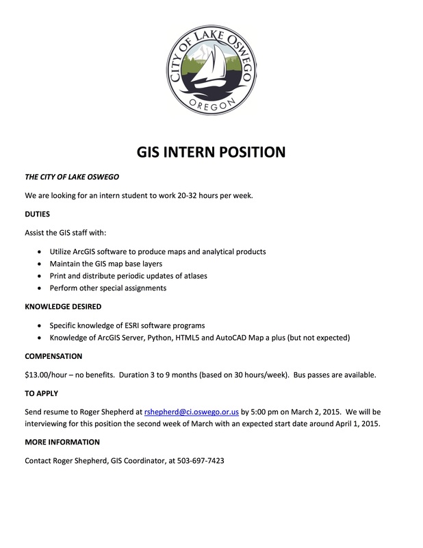
GIS Intern with the City of Lake Oswego

0 Comments

Read Now
 
Picture

Share

0 Comments

2/23/2015

Design it, build it and pitch it - PCC Hackathon

0 Comments

Read Now
 
Calling all students:

Design it, build it and pitch it - all in one weekend!

Portland Community College is looking for students to be part of its first-ever Hackathon. Teams of like-minded makers can join together to design and build innovative products using some of the newest technology available. 

These creative developers and entrepreneurs will have access to tools such as 3D printers, laser cutters, Intel microcomputers, Autodesk software, soldering equipment, and even sewing machines. Best of all, mentors from the business and education worlds will be there to help with ideas and give encouragement. 

The Hackathon takes place over a three-day time period at PCC Sylvania, beginning Friday, February 27 
and ending Sunday, March 1. No experience is required, but registration is limited to 50 students on a first come-first served basis. 

On the final day, teams can showcase their accomplishments to professionals in the industry. Prizes, including t
ablets, microcomputers and gift cards will be awarded to top top winners. Individual prizes will also be raffled.

The PCC Hackathon is supported in part by Autodesk, Intel and PCC Sylvania's Maker Space. Hours are Friday and Saturday 8:30 a.m. - 8:30 p.m. and Sunday 8:30 a.m. - 3:30 p.m. Food and beverages are provided. 
Students can register at http://goo.gl/forms/tohtlQwMPh

Share

0 Comments

2/16/2015

Senior GIS Solutions Specialist w/ WA Dept of Social & Health Services

0 Comments

Read Now
 
Job Title: Senior GIS Solutions Specialist (00643)
Opening Date/Time: Thu. 01/29/15 12:00 AM Pacific Time
Closing Date/Time: Wed. 02/18/15 11:59 PM Pacific Time
Salary: $66,420.00 - $89,280.00 Annually 
Job Type: Full Time - Permanent
Location: Thurston County – Olympia, Washington
Department: Dept. of Social and Health Services

For full job description: 
Senior GIS Solutions Specialist (00643) - closes 2/18

Share

0 Comments

2/16/2015

February PDX OS-Geo meeting

0 Comments

Read Now
 
Join PDX-OSGeo for the February meeting Wednesday February 18th at 6pm in Cramer Hall, Room 409

Details on Calagator: http://calagator.org/events/1250467856

Bring snippets of whatever awesome geo-stuff you want to discuss this month, and to hear Nick Martinelli talk about a very cool project that he will share that uses CartoCSS and UTFGrids for collaborative mapping.

Share

0 Comments

2/16/2015

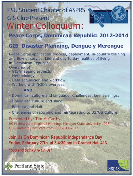
PSU GIS Colloquium: Friday Feb 27, 3 - 4:30 pm, Cramer Hall, Room 413

0 Comments

Read Now
 
Picture

Share

0 Comments

2/11/2015

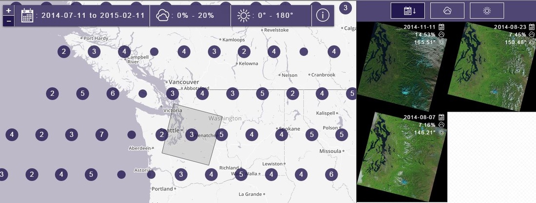
Landsat 8 data now available!

0 Comments

Read Now
 
Picture
Here is a the new data delivery site for Landsat 8 data:

http://libra.developmentseed.org/

Share

0 Comments

2/11/2015

Conservation GIS Happy Hour (portland)

0 Comments

Read Now
 
February's 2nd Wednesday is approaching fast, sorry for the late notice here.
 Let's try a new part of town and a fairly new bar for some of us.
 
Ex-Novo in North Portland
2326 N Flint Ave
 
it is just west of Vancouver and south of Russell street

Share

0 Comments

2/3/2015

GIS Analyst w/ Pacificorp

0 Comments

Read Now
 
Picture


GIS Analyst

Portland, Oregon

General Purpose
Performs functions including GIS analysis, spatial data acquisition, quality control, modeling, integration; spatial database development; development of processes and solutions; support of other business systems utilizing spatial data; cartographic production; calculation and reporting of spatial statistics; and tracking of work activities.  Develops and maintains operational and procedural documentation and adheres to departmental standards.

Responsibilities of this position include the following:
  • Design, development and implementation of moderately complex GIS processes including: data analysis, manipulation, transformation, integration, mapping, and GIS application solutions.
  • Interpret moderately complex data and present results of the analyses to diverse business clients in the form of reports or map products.
  • Conduct moderately complex analyses thorough research and gathering of data.
  • Assists with planning, utility data modeling, site selection studies, other business section consulting, and asset management.
  • Collaborate with internal company clients to solve business problems using GIS technology and knowledge.
  • Assist in developing standards and automated processes through project work.
  • Conduct research requests, develop conclusions and provide recommendations to stakeholders.
  • Support marketing of GIS services to company business units to generate new business.
  • Works independently and participates on project teams to prepare technical reports, presentations, and implementation plans; define GIS application strategies; and develop detailed project deliverables.

Requirements of this position include the following:

  • Bachelor’s degree in Geographic Information Systems (GIS), Natural Resources, Geography or a related field; or the equivalent combination of education and experience.
  • A minimum of three years related experience using ArcGIS and extensions.
  • Communication and interpersonal skills, including the ability to consult, negotiate, and resolve internal and external customer issues which may be critical, sensitive, or urgent in nature.
  • Demonstrated ability to apply theoretical and pragmatic practices and techniques to GIS assignments.
  • Ability to quickly learn and understand the diverse business processes of an electric utility and apply the appropriate set of geospatial analysis to provide decision support products.
  • Ability to conceptualize impacts and understand outcome/results of business decisions.
  • Assessment skills including problem diagnosis and identification of proper methods and techniques to resolve issues and prevent future problems.
  • Knowledge of current technologies applying training and experience to current and future problems.
 
Preference may be given to candidates who meet that above requirements and have the following:
  • Advanced degree.
  • Python scripting experience.
  • Automation of GIS processes using FME.
  • ArcGIS Server (SDE) experience.
  • Knowledge of basic electrical distribution power systems.
  • ArcObjects .NET programming experience.
  • Experience with RDBMS and SQL.
 
Employees must be able to perform the essential functions of the position with or without an accommodation.

To apply, please visit our website at www.pacificorp.com and click on the Careers tab.  Reference job #141542.

At PacifiCorp, we encourage everyone to work together. We embrace diversity and value the distinct perspectives of all our employees. We strive to cultivate a workplace that connects each employee to the organization and enables all individuals to participate and contribute to their full potential.  

It is PacifiCorp's policy to provide and promote equal employment opportunity to all employees and applicants in accordance with local, state and federal laws and regulations governing personnel activities. In accordance with federal guidelines, PacifiCorp is committed to a program of affirmative action. All qualified applicants will receive consideration for employment without regard to race, color, religion, sex, disability, veteran status, national origin, sexual orientation or gender identity.

All offers of employment are contingent upon the successful completion of a background check and drug screening.

Share

0 Comments

2/3/2015

GIS Technician w/ Cowlitz Public Utility District 1

0 Comments

Read Now
 
Picture
Public Utility District No. 1 of Cowlitz County (better known as Cowlitz PUD) is a publicly owned municipal corporation of the State of Washington. The purpose of this municipal corporate organization is for efficient generation, transmission and distribution of electrical energy. The PUD is owned by the residents of Cowlitz County and operates on revenues from the sales of its services. The PUD has waived its right to collect tax revenue despite authority to do so. 

The primary purpose of this position is to provide mapping and facility asset management for the District’s GIS using the District’s ArcMap/ArcFM based Geographic Information System (GIS) and work order management systems. 

The ideal candidate must have an Associate’s degree or equivalent course work from a vocational or technical school in geographic information systems, geography, planning or computer science plus a minimum of one year of progressively responsible experience providing GIS functions. Preference may be given for Bachelor’s degree in Computer Science, Geography or related field from an accredited fouryear college or university. 

Cowlitz PUD is an Equal Opportunity Employer, and all qualified candidates are encouraged to apply. This recruitment will remain open until Friday, February 6, 2015. To apply for this position you must provide a cover letter, resume, completed supplemental questions, and completed Cowlitz PUD application. Incomplete application packets will not be considered. 

Please Note: To be eligible for full-time, regular employment at Cowlitz PUD, you must be authorized to work in the United States when you begin your employment. If you do not have the right to work in the United States at that time, please be aware that Cowlitz PUD is not in a position to provide sponsorship, participate in Optional Practical Training programs, or support changes to your immigration status. 

Please submit to: Cowlitz PUD Attn: HR PO Box 3007 Longview, WA 98632 
OR Scan and email to: jobs@cowlitzpud.org

Click here to download the application

Share

0 Comments
<<Previous
Details

    Archives

    March 2023
    February 2023
    January 2023
    December 2022
    November 2022
    October 2022
    September 2022
    August 2022
    July 2022
    June 2022
    May 2022
    April 2022
    March 2022
    February 2022
    January 2022
    December 2021
    November 2021
    October 2021
    September 2021
    August 2021
    July 2021
    June 2021
    May 2021
    April 2021
    March 2021
    February 2021
    January 2021
    December 2020
    November 2020
    October 2020
    September 2020
    August 2020
    July 2020
    June 2020
    May 2020
    April 2020
    March 2020
    February 2020
    January 2020
    December 2019
    November 2019
    October 2019
    September 2019
    August 2019
    July 2019
    June 2019
    May 2019
    April 2019
    March 2019
    February 2019
    January 2019
    December 2018
    November 2018
    October 2018
    September 2018
    August 2018
    July 2018
    June 2018
    May 2018
    April 2018
    March 2018
    February 2018
    January 2018
    December 2017
    November 2017
    October 2017
    September 2017
    August 2017
    July 2017
    June 2017
    May 2017
    April 2017
    March 2017
    February 2017
    January 2017
    December 2016
    November 2016
    October 2016
    September 2016
    August 2016
    July 2016
    June 2016
    May 2016
    April 2016
    March 2016
    February 2016
    January 2016
    December 2015
    November 2015
    October 2015
    September 2015
    August 2015
    July 2015
    June 2015
    May 2015
    April 2015
    March 2015
    February 2015
    January 2015
    December 2014
    November 2014
    October 2014
    September 2014
    August 2014
    July 2014
    June 2014
    May 2014
    April 2014
    March 2014
    February 2014
    January 2014
    December 2013
    November 2013
    October 2013
    September 2013
    August 2013
    July 2013
    June 2013
    May 2013
    April 2013
    March 2013
    February 2013
    January 2013
    December 2012
    November 2012
    October 2012
    September 2012
    August 2012
    July 2012
    June 2012
    May 2012
    April 2012
    March 2012
    February 2012
    January 2012
    December 2011
    November 2011
    October 2011
    September 2011
    August 2011
    July 2011
    June 2011
    May 2011
    April 2011
    March 2011
    February 2011
    January 2011
    December 2010
    November 2010
    October 2010
    September 2010
    August 2010
    July 2010
    June 2010
    May 2010
    April 2010
    March 2010
    February 2010
    January 2010
    December 2009
    November 2009
    October 2009
    September 2009
    May 2009
    April 2009

    Categories

    All
    Aag
    Americorps
    Animations
    Applied GIS
    Applied Gis
    Apps
    Article
    Articles
    Asprs
    Books
    Careers
    Cartography
    Competition
    Conferences
    Conservation
    Diaster Mapping
    Drones
    Environmental
    Esri
    Events
    Fellowships
    Games
    Geoapp
    Geographic Awareness
    Geography
    Geomatics
    Geospatial Technologies
    GIS
    GIS Data
    Gis Data
    GIS Day
    GIS Day
    GIS Resources
    Gis-resources
    Google
    Google Earth
    Google Maps
    Gps
    Graduate School
    Grants
    Happy Hour
    Happy Hours
    Humor
    Hydrology
    International
    Internships
    Interviews
    Job
    Jobs
    Journals
    Lecture
    Lidar
    Maps
    Meeting
    National Geographic
    Natural Resources
    Open Source
    Oregon
    PCC
    Podcast
    Porland
    Portland
    Presentations
    Professional Development
    Professional-development
    Projections
    Raster
    Remote Sensing
    Research
    Scgis
    Scholarships
    Social Networks
    Software
    Songs
    STEM
    Story Maps
    Study Abroad
    Surveying
    Technical Help
    Tools
    Training
    UAS
    UAV
    University
    Urban Design
    Videos
    Visualization
    Webinar
    Web Mappping
    Websites
    Women In GIS
    Workshops

    RSS Feed

Contact ME

  • Home
  • About Me
  • Courses
  • GIS Club
    • About Us
    • Don't be a Dangle!
    • Event Calendar
  • Resources
    • Data
    • Tools
    • Blogs
    • ArcGIS Install
  • Blog
  • Aventuras Colombianas