CHRISTINA FRIEDLE

Geospatial Jobs, Internships, events, news & More

  • Home
  • About Me
  • Courses
  • GIS Club
    • About Us
    • Don't be a Dangle!
    • Event Calendar
  • Resources
    • Data
    • Tools
    • Blogs
    • ArcGIS Install
  • Blog
  • Aventuras Colombianas

11/24/2014

Geospatial Analyst w/ Air Sciences, Inc.

0 Comments

Read Now
 
Picture
We are seeking an environmental scientist with experience analyzing and managing environmental data using geographic information system (GIS) principles. This includes extensive use of GIS software (R, ERDAS IMAGINE, ESRI suite), programming and scripting languages (R, Python, Perl, SQL) and spatial databases (PostGIS, SQL Server). Experience with multispectral image analysis/processing and object-based image analysis (OBIA) is a plus.

Typical responsibilities will involve analysis of air quality dispersion
model input and output, statistical modeling using vector and raster datasets, developing and maintaining spatial databases for internal and Web-based use, and applying air quality concepts to remote sensing analysis. The successful candidate will be driven, possess a graduate degree in one of the environmental or physical sciences, comfortable using open-source tools, possess and curious mind, and be excited by new challenges.

Air Sciences offers competitive salary and benefits packages.  We will consider candidates with a range of professional experience. Air Sciences Inc. sincerely appreciates the efforts of all who submitted letters of interest and resumes for positions that have been posted in the past or for general inquiries.

The listing is here: 
http://airsci.com/contact/#employment

Share

0 Comments

11/24/2014

GIS Specialist w/ Umatilla Electric Cooperative

0 Comments

Read Now
 
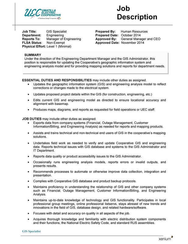
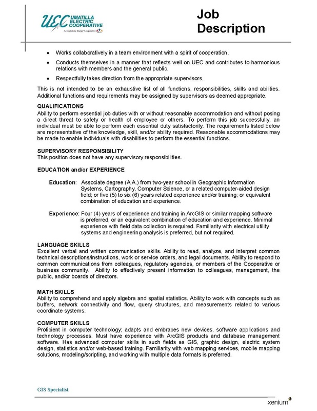
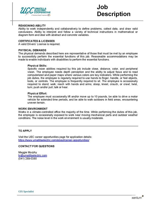
Umatilla Electric Cooperative in Hermiston is hiring a GIS Specialist. The posting below has the details, but here is a link to the description and application details: https://www.umatillaelectric.com/about/career-opportunities/
Picture
Picture
Picture

Share

0 Comments

11/24/2014

GIS Technician, Specialist, & Analyst w/ City of Bozeman

0 Comments

Read Now
 
Picture
The City of Bozeman is expanding its GIS Department!  A total of three separate full-time positions are open at this time (Technician, Specialist, Analyst).  This will be an excellent opportunity for all levels of experience and education, as we look forward to taking municipal GIS to the next level.

For position and wage information please visit www.bozeman.net/jobs

Application Deadline: Monday, December 1, 2014 @ 5:00pm

Share

0 Comments

11/17/2014

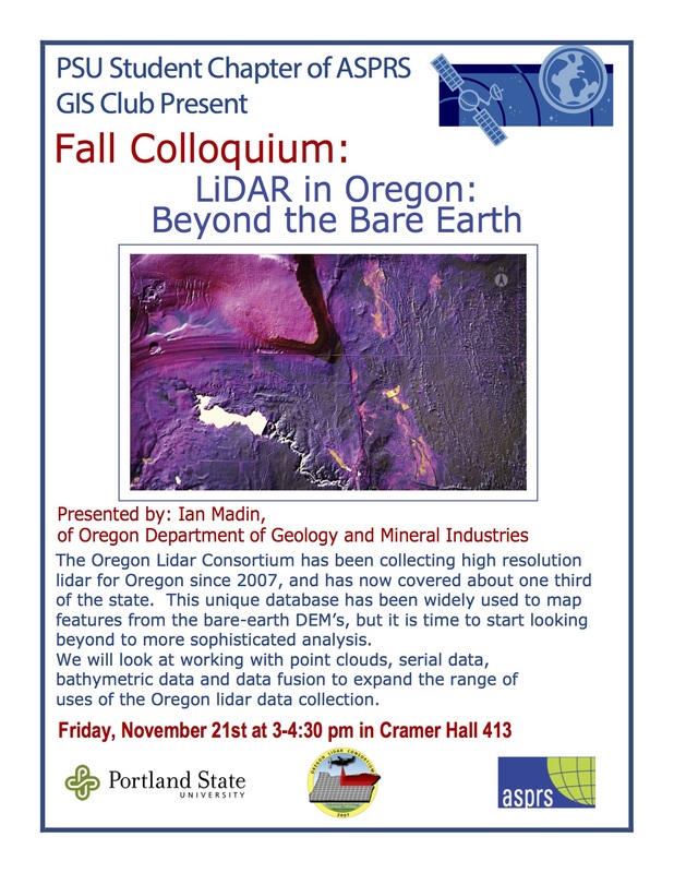
PSU GIS Colloquium: Friday, Nov. 21, 3:00 - 4:00 Cramer Hall, Room 413

0 Comments

Read Now
 
Picture

Share

0 Comments

11/17/2014

Enterprise GIS Manager w/ Wilderness Society

0 Comments

Read Now
 
Picture
The Wilderness Society's Center for Landscape Analysis is hiring an Enterprise GIS Manager:  https://home.eease.adp.com/recruit2/?id=10822301&t=1.


Overview:
The Enterprise GIS Manager is a GIS professional position applying technological, visual design, and leadership skills to advance The Wilderness Society’s mission and campaigns to achieve land conservation and address real world public land management challenges. This position works in the nexus between science, communication, conservation advocacy, and public policy. The incumbent will apply his/her skills to help integrate spatial information with all TWS campaigns and departments to help achieve our conservation and philanthropic goals.
 
The primary role of this position is to envision, promote, develop, and maintain enterprise GIS systems and tools to support the availability and application of spatial information throughout the organization. The work involves staying abreast of enterprise GIS technological advancements, anticipating the value of desktop, enterprise and cloud based capabilities to TWS’ work, and promoting the use of those capabilities. The Enterprise GIS Manager helps develop and maintain the hardware and software systems necessary to support enterprise GIS, conducts product needs assessments, constructs products (solely or in partnership with users) to satisfy those needs, and trains users in product use and maintenance. Secondary roles of this position include assisting in the management of our enterprise license agreement with ESRI and supporting non-professional GIS staff at TWS through mentoring and technical skills transfer.
 
Though this position works closely with information technology, conservation, policy, communications, philanthropy, and science staff, the nature and importance of science work make clear the value of a scientific background to successfully fulfilling the responsibilities of this position. The Enterprise GIS Manager is a member of the team of scientists and GIS professionals making up the Center for Landscape Analysis (CLA)—a subset of a larger science team. 
Share

0 Comments

11/17/2014

GIS Technician w/ NW Natural

0 Comments

Read Now
 
Picture
GIS Technician 1
Union Position
Engineering: Portland, OR
Regular; Full-Time
Posting #50154314
November 7, 2014

General Purpose:
Maintains and updates engineering records through operation of a GIS, CAD, or computer graphics system.

General Essential Functions:
  • Reads and interprets construction data and sketches.
  • Enters data into system.
  • Generates maps and engineering drawings and sketches.
  • Verifies and revises engineering records.
  • Researches and retrieves data from internal sources such as FileNet, OrMap, and Microfilm.
  • Maintains inventory of mains and services.
  • Organizes files, documents, maps, and drawings.
  • Acts and communicates in a professional, respectful, and cooperative manner in connection with all activities associated with NW Natural.
  • Follows supervisory instructions and is flexible and adaptable to changing conditions and expectations.
  • Maintains punctual, regular, and reliable attendance.
  • Demonstrates the Company’s core values and complies with all Company policies and procedures.


Essential Function Requirements:

  • Associate’s degree in computer drafting or equivalent experience.
  • Mechanical drafting, mapping, or survey experience preferred.
  • Experience with ArcInfo or other computer mapping system preferred.
  • Ability to interpret and produce maps, drawings, and records using engineering standards.
  • Ability to visualize and understand drawings and design concepts.
  • Basic math and reading skills.
  • Basic ability to access, input, and retrieve information from a computer.
  • Data entry skills of 6,000 kph with 90% accuracy.
  • Basic knowledge of the Company’s organization, inter-relationships, policies, procedures, processes, and department/work specific requirements.
  • Ability to communicate with employees and customers to answer questions or resolve issues with tact and diplomacy.
  • Ability to deal with sensitive information in a confidential manner.
  • Sustained sitting for 6-8 hours per day, hand/finger dexterity, and ability to grasp, bend, lift, reach, and stoop.
  • Near vision and color discrimination abilities.


Qualification Period
:
6 months

This position will be tested on:
ACT Locating Information - Level 5
ACT Applied Mathematics - Level 4

Hourly Wage:   $25.11 (Grade 140)

Application Process:  Submit complete electronic application including cover letter and resume.  https://www.nwnatural.com/Careers/JobOpportunities

Applications will be reviewed once application deadline has passed.
Deadline: November 21, 2014

NW Natural is an EEO/AA employer that values diversity and inclusion in the workplace. We strongly encourage those protected by Section 503 or VEVRAA to apply. We also promote a drug-free work environment.


Share

0 Comments

11/12/2014

Opportunities with International Student Volunteers - Info Session at PCC-Sylvania on 11/14/14 @ 10:30am

0 Comments

Read Now
 
Picture

Share

0 Comments

11/10/2014

New York Natural Heritage Program Is Hiring (2 positions) Part-Time GIS Specialist, and Spatial Ecologist/Modeler

0 Comments

Read Now
 
Picture
The New York Natural Heritage Program is looking to fill to GIS related positions in Albany, NY.


Part Time GIS Specialist: http://esf.interviewexchange.com/jobofferdetails.jsp?JOBID=54517

Full Time Research Scientist (Spatial Ecologist/Modeler): http://esf.interviewexchange.com/jobofferdetails.jsp?JOBID=54514

The New York Natural Heritage Program (NYNHP) is a program of the Research Foundation for the State University of New York College of Environmental Science and Forestry (SUNY- ESF) whose mission is to facilitate the conservation of New York’s biodiversity by providing comprehensive information and scientific expertise on rare species and natural ecosystems. NYNHP works in partnership with the New York State Department of Environmental Conservation and other state, federal and private organizations involved in natural resource management, land protection and stewardship, and advancing the conservation of biodiversity.

Share

0 Comments

11/10/2014

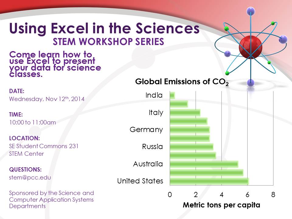
PCC STEM Workshop - Using Excel in the Sciences

0 Comments

Read Now
 
Picture

Share

0 Comments

11/6/2014

More than 14 million environmental sampling records from National Laboratory are now available online

0 Comments

Read Now
 
LOS ALAMOS, N.M. – Regulators, stakeholders, scientists and the greater public will have access to remediation and other environmental data records associated with EM’s legacy nuclear cleanup program in near real time on a new website portal.   Conversion to this cloud-based system achieved a substantial reduction in operating and maintenance costs, with changes and process improvements resulting in an estimated total cost savings of more than $15 million through 2015.

Previously contained in a dozen independent databases, the integrated records of Los Alamos National Laboratory (LANL) — part of DOE’s network of national laboratories — are now stored in one location, the website Intellus.

The system contains 14 million records, including more than 28,000 locations and about 300,000 samples. The data span a wide range of media including air, soil, sediment, biota, and water, and it includes various analytes and time periods.

Share

0 Comments
<<Previous
Details

    Archives

    March 2023
    February 2023
    January 2023
    December 2022
    November 2022
    October 2022
    September 2022
    August 2022
    July 2022
    June 2022
    May 2022
    April 2022
    March 2022
    February 2022
    January 2022
    December 2021
    November 2021
    October 2021
    September 2021
    August 2021
    July 2021
    June 2021
    May 2021
    April 2021
    March 2021
    February 2021
    January 2021
    December 2020
    November 2020
    October 2020
    September 2020
    August 2020
    July 2020
    June 2020
    May 2020
    April 2020
    March 2020
    February 2020
    January 2020
    December 2019
    November 2019
    October 2019
    September 2019
    August 2019
    July 2019
    June 2019
    May 2019
    April 2019
    March 2019
    February 2019
    January 2019
    December 2018
    November 2018
    October 2018
    September 2018
    August 2018
    July 2018
    June 2018
    May 2018
    April 2018
    March 2018
    February 2018
    January 2018
    December 2017
    November 2017
    October 2017
    September 2017
    August 2017
    July 2017
    June 2017
    May 2017
    April 2017
    March 2017
    February 2017
    January 2017
    December 2016
    November 2016
    October 2016
    September 2016
    August 2016
    July 2016
    June 2016
    May 2016
    April 2016
    March 2016
    February 2016
    January 2016
    December 2015
    November 2015
    October 2015
    September 2015
    August 2015
    July 2015
    June 2015
    May 2015
    April 2015
    March 2015
    February 2015
    January 2015
    December 2014
    November 2014
    October 2014
    September 2014
    August 2014
    July 2014
    June 2014
    May 2014
    April 2014
    March 2014
    February 2014
    January 2014
    December 2013
    November 2013
    October 2013
    September 2013
    August 2013
    July 2013
    June 2013
    May 2013
    April 2013
    March 2013
    February 2013
    January 2013
    December 2012
    November 2012
    October 2012
    September 2012
    August 2012
    July 2012
    June 2012
    May 2012
    April 2012
    March 2012
    February 2012
    January 2012
    December 2011
    November 2011
    October 2011
    September 2011
    August 2011
    July 2011
    June 2011
    May 2011
    April 2011
    March 2011
    February 2011
    January 2011
    December 2010
    November 2010
    October 2010
    September 2010
    August 2010
    July 2010
    June 2010
    May 2010
    April 2010
    March 2010
    February 2010
    January 2010
    December 2009
    November 2009
    October 2009
    September 2009
    May 2009
    April 2009

    Categories

    All
    Aag
    Americorps
    Animations
    Applied GIS
    Applied Gis
    Apps
    Article
    Articles
    Asprs
    Books
    Careers
    Cartography
    Competition
    Conferences
    Conservation
    Diaster Mapping
    Drones
    Environmental
    Esri
    Events
    Fellowships
    Games
    Geoapp
    Geographic Awareness
    Geography
    Geomatics
    Geospatial Technologies
    GIS
    GIS Data
    Gis Data
    GIS Day
    GIS Day
    GIS Resources
    Gis-resources
    Google
    Google Earth
    Google Maps
    Gps
    Graduate School
    Grants
    Happy Hour
    Happy Hours
    Humor
    Hydrology
    International
    Internships
    Interviews
    Job
    Jobs
    Journals
    Lecture
    Lidar
    Maps
    Meeting
    National Geographic
    Natural Resources
    Open Source
    Oregon
    PCC
    Podcast
    Porland
    Portland
    Presentations
    Professional Development
    Professional-development
    Projections
    Raster
    Remote Sensing
    Research
    Scgis
    Scholarships
    Social Networks
    Software
    Songs
    STEM
    Story Maps
    Study Abroad
    Surveying
    Technical Help
    Tools
    Training
    UAS
    UAV
    University
    Urban Design
    Videos
    Visualization
    Webinar
    Web Mappping
    Websites
    Women In GIS
    Workshops

    RSS Feed

Contact ME

  • Home
  • About Me
  • Courses
  • GIS Club
    • About Us
    • Don't be a Dangle!
    • Event Calendar
  • Resources
    • Data
    • Tools
    • Blogs
    • ArcGIS Install
  • Blog
  • Aventuras Colombianas