|
The Institute for Natural Resources is a hiring a GIS analyst beginning as soon as possible and going through the summer terms with possible extension into the academic year. This position will support the State of Oregon’s Greater Sage-Grouse planning effort by mapping and analyzing development in its range in central and eastern Oregon. Initial tasks include converting the current database structure to an alternative format, performing overlay analyses and calculations, reporting results in an organized manner, and simple cartography. Analysis results are typically contained in an Excel spreadsheet, so basic Excel skills are a plus. The position requires 12 – 20 hours of work per week. Please see the position description below for more details.
Position Description The GIS Analyst will be responsible for working with INR to digitize human-caused disturbances and other tasks as necessary such as assimilate county zoning data into a single spatial geodatabase. The Analyst will report to the SageCon Technical Coordinator. Major Responsibilities:
Required Qualifications
Preferred Qualifications
If you are interested in this position, please send an email to Dr. Theresa Burcsu ([email protected]) with the subject “INR GIS Analyst Position”, a cover letter, and a resume. Review of applications will begin on May 25 and will be accepted until the position is filled.  Quantum Spatial is in search of multiple persons to fill full-time, temporary, hourly positions for Remote Sensing Technicians in our Portland, OR office. We are looking to fill these positions immediately.
About Quantum Spatial: Quantum Spatial has established itself at the forefront of LiDAR production and LiDAR-derived feature extraction, and exhibits a growing presence on a national scale. Employment at Quantum Spatial provides a unique opportunity to immerse oneself in this rapidly evolving and expanding remote sensing field. This job posting refers only to openings in the Portland office. For more information on the diversity of products and projects maintained by Quantum Spatial, including thermal infrared remote sensing analysis and watershed modeling, please see our website at http://www.quantumspatial.com/ Required Qualifications: A successful candidate will have a 4-year degree in natural sciences, geography, engineering, surveying, or a related field. Candidates must possess an interest in remote sensing and geodetics, and understand the nature of quantitative data. Duties and Responsibilities: The responsibilities for this position include processing and analysis of a variety of spatial data products (including LiDAR data, Orthophotos, and Video) and general analysis support. The position requires the ability to maintain productivity while performing repetitive tasks and working to meet deadlines in a fast paced environment. Applicants with GIS coursework or applicable work experience are preferred. Knowledge, Skills, and Abilities: We are looking for individuals with the ability to be successful working independently, as well as in a team setting. The ideal candidate is self-motivated with excellent decision making and problem solving abilities, computer proficient, and has an interest in GIS and remote sensing. An understanding of geospatial concepts and GPS survey methods is desired, but not mandatory. Though not required, experience in the following areas is greatly desired:
It is the policy of Quantum Spatial to provide equal opportunity for all qualified persons and not to discriminate against any employee or applicant for employment because of race, color, religion, sex, age, national origin, sexual orientation, veteran status, disability, or any other protected status. Resumes will be accepted until all positions are filled. Immediate submissions are welcome and will be reviewed promptly. All job offers with Quantum Spatial are contingent upon passing a background check and drug screening. To apply: http://quantumspatial.com/about-us/our-team AND send a cover letter & application directly to: Jonathan Ellinger GISP, CP, CMS/RS Advanced Imaging Lead P: 503-505-5100 ext. 5321 E: jellinger@quantumspatial.com W: ww.quantumspatial.com They are hoping to fill the positions by mid-June The 18th Framework Forum is this Wednesday, May 20th, 10:00am – 4:00pm
If you have not done so yet, please register (using your full name and agency) on the Doodle Poll athttps://doodle.com/m3fw7uieutkg2pu9 to reserve your seat, there are still a few spaces available. This event is free and open to all GIS professionals in the state of Oregon. Chemeketa Center for Business and Industry 626 High St. NE Salem, OR 97301 Click here for a map We are in rooms 102/103. These rooms are to the right when you walk in the front door on the first floor. For parking, it is suggested that attendees park across the street in the Marion Parkade which is free for the day. You can park anywhere except the roof of the Parkade. 9:00 Coffee and light pastries available for those arriving early 10:00 -10:15 Welcome and Introductions: Bob DenOuden, GEO 10:15 -10:45 Oregon Soils Framework Standard and Dataset: Ian Reid, NRCS 10:45 – 11:30 ESRI on the Web: ArcGIS Online, Web API’s, and New Tech: Josh Tanner, GEO 11:30 – 12:00 Mt. Hood Multi-Hazard Risk Assessment: An Analysis Combining Hazard and Assessor Data: Jed Roberts, DOGAMI 12:00 – 1:00 Lunch (provided) 1:00 – 1:30 Statewide Flood Hazard Geodatabase: Jed Roberts (DOGAMI), Steve Lucker (DLCD) 1:30 -2:00 Proposed Oregon Historical Railroad data standard: Emmor Nile (ODF)/Ed Kamholz 2:00 – 2:30 Fish Habitat Distribution Data Standard update: Jon Bowers, ODFW 2:30 – 2:45 break 2:45 -3:15 Proposed Amended Oregon Metadata Standard: Bob DenOuden, GEO 3:15 – 4:00 GEO update and discussion 4:00 adjourn The PSU Geospatial Information Society will host its ever-popular annual Career Panel on Friday, May 15, from 3:30 - 5:30 pm, Cramer Hall 413 Our panelists, consisting of GIS professionals from the Portland metro region, will talk about the GIS employment landscape, discuss the qualities and knowledge that their organizations look for in job candidates, offer job search tips, and answer questions from the audience. A representative from PSU Advising and Career Services will also be present to talk about job search strategies, and to describe the ways that Career Services can provide assistance. Food, of course, will be available! 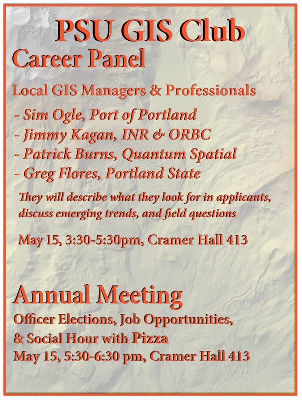 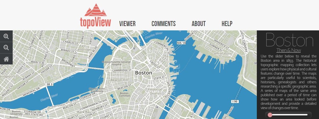 USGS just made it so much easier to access current and old topographic maps - this viewer allows you to see any topographic map dating back to the 1880's! There's over 178,000 of them and they are free and downloadable.
Check it out: http://ngmdb.usgs.gov/maps/Topoview/  The Sonoma County Agricultural Preservation and Open Space District is seeking a Conservation GIS Analyst. This is a unique opportunity to apply your passion and skills at an innovative local land conservation organization. The position closes this Friday (May 8th).
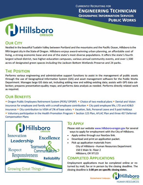
Read about the position and apply here (note the link to the PDF brochure at the top of the Position Information). Location: Salt Lake City, Utah
Position: Geographic Information Systems (GIS) Analyst Company Background: Global Consulting International (GCI) is an international SBA certified 8a business with its headquarters in Salt Lake City Utah. GCI offers a range of services and solutions to government, commercial and non-profit clients related to engineering, information technology, medical support, logistics and intelligence. GCI currently provides on-site GIS and Information Technology support to the USDA Forest Service Geospatial Service and Technology Center (GSTC) in Salt Lake City Utah. GSTC is a detached Washington DC Office and a center of excellence within the Forest Service. This facility hosts a variety of national geospatial programs, projects, and services for the agency. Position Description: The GIS Analyst is a full-time on-site contract position within the GSTC Training and Technology Integration Unit (TTI) at GSTC. This position will participate in national GIS programs including the GIS Helpdesk, Geospatial Training, GIS analysis, and web GIS technology support. The selected candidate will have a strong background in Esri desktop and enterprise software applications and products. Experience and familiarity with the following products is necessary: ArcGIS Desktop application and extensions, ArcServer, AGOL, ArcSDE and ArcPy. The individual should have the aptitude and skills necessary to provide GIS Support to the agency’s geospatial user community on a variety of geospatial questions and issues. The candidate will need the ability to participate as needed with the development and deployment of geospatial training to Forest Service GIS users. Experience performing complex and advanced GIS analysis such as multi-criteria analysis, viewshed analysis, accuracy assessment, data comparisons, and data suitability is desired. The selected applicants should be familiar with Esri web mapping technologies such as ArcServer, ArcPortal, map services, and ArcGIS Online (AGOL). The desired candidate will have strong communication skills including verbal, technical writing and presentation skills. The ability to work well in a team environment and individually on specific projects is necessary. The selected candidate must be self-directed, motivated with an aptitude for troubleshooting and problem solving outside of their technical competencies. Education: A minimum of a BA/BS degree preferably in geography, natural resources is required. Two or more years of GIS experience is needed. Graduate course work and/or degree are preferred. Salary is dependent upon qualifications and experience. This position offers a benefits package which includes health coverage, 401k, paid vacation and holidays. Application review will start immediately and the position will start as soon as practical. Please submit a resume and cover letter as an application for this position. GCI is an Equal Opportunity Employer. All qualified applicants will receive consideration for employment without regard to race, color, gender, sexual orientation, disability, or national origin. GCI gives preferential treatment to veterans. PC Trask & Associates, Inc. is seeking a creative, highly talented candidate for environmental planning and restoration. Masters degree or equivalent work experience preferred. Must have strong GIS and excellent writing skills.
Small business environment in downtown Portland with competitive wages and benefits. Please email a resume and cover letter to [email protected]. Natural Resources Planner I Job Description: Entry level position; provides assistance and support to staff on a range of natural resource planning and management projects. Relies on senior staff for assignments and direction.
Required Education and Experience:
Required Skills and Abilities:
Desired Skills and Abilities:
 This year we will be reaching out to our participants to help us create the Conference T‐shirts in celebration for our joint conference and the 30th Anniversary of the Northwest GIS User Group. The 2015 Joint Conference Committee is now seeking a design for the 2015 Conference T‐shirt. The winning entry will have the choice of a $250 cash prize or a free conference registration.
Who: Members, Participants, and friends of International URISA, its local chapters, and the Northwest GIS User Group are invited to participate in the URISA GIS-Pro & NWGIS 2015 Conference T-shirt Design contest. What: Design entries of original artwork for the T-shirt Art Contest are to:
Where: Submit design entries to [email protected] with subject line containing the words “Conference Logo Submission” or via mail to Linda Davis, NWGIS/URISA Conference, IDWR, 322 East Front Street, Boise, Idaho 83720. Why: Art work of all finalists will be displayed publicly in conjunction with the URISA GIS-Pro & NWGIS 2015 Conference activities. Recognition may be given to the runner up designs. Note: The winning artist gives the Joint Conference Committee the right to use the winning artwork for projects promoting the URISA GIS-Pro & NWGIS 2015 Conference. The artist must grant URISA and/or their Chapters and NWGIS the right to use the submitted image in whatever way he/she might feel suitable for the purposes of publication and broadcast. Artist must waive all rights over the image and understand that it might be cropped, altered or modified for said purpose. Artist gives permission for use, re-use, publish or re-publish in whole or in part, in any medium. Background Information: URISA is the leader in connecting people and resources for the geospatial community. A multi‐disciplinary geospatial organization, URISA provides education and training, a vibrant and connected community, advocacy for geospatial challenges and issues, and essential resources. Since 1963, URISA members and friends from around the world have convened annually to learn about, share and discuss all things geospatial. The Northwest GIS User Group, Inc. is a non‐profit organization that provides a forum for training, exchange of knowledge, techniques, and data among the users of GIS software and related GIS products and services. The Northwest GIS User Group provides a yearly conference in the fall where people from Idaho, Montana, Oregon, Washington and beyond present and exchange information. These well‐known national and regional organizations, along with local URISA chapters (Northern Rockies and Washington), are coming together for the first time ever in Spokane, WA for the URISA GIS-Pro & NWGIS 2015 Conference - Geography at the Nexus of Collaboration - at the Grand Hotel in Spokane, WA. |
Categories
All
Archives
June 2024
|
 RSS Feed