|
The Northwest Environmental Training Center is offering a 3-day course in Advanced GIS Concepts:
Advanced Model Builder and Python Techniques for Geoprocessing in ArcGIS 10 Course ID:GIS-503 Status:OPEN Date(s):Dec 19, 2011: 9:00 AM - 5:00 PM Dec 20, 2011: 9:00 AM - 5:00 PM Dec 21, 2011: 9:00 AM - 5:00 PM Location:Evergreen State College Computer Lab Olympia, WA Instructor: Stefan Freelan & Tyson Waldo Tuition:$745 / $645* $695 / $595* (before Oct 15, 2011) COLUMBIA RIVER & PUGET SOUND REGIONS
15th ANNUAL TECHNICAL EXCHANGE The ASPRS CRR/Puget Sound Region Joint Technical is coming up and we still have presenter slots available. Please send your registration and abstract, if you are presenting, to Matt Boyd by September 30th. We're looking forward to seeing you there! Date: Friday, October 7th, 2011 Time: 9:00-3:00 (Setup time available for presenters: 8:00-9:00 a.m.) Place: Vancouver Water Resource Education Center 4600 SE Columbia Way, Vancouver, Washington 98661, (360) 696-8478 [MAP IT] Registration / Abstract Deadline: September 30th, 2011 Registration Fees: ASPRS Members $25.00 (Includes box lunch and copy of abstracts) Non-members $35.00 (Includes box lunch and copy of abstracts) ASPRS Student Member Free + Optional Lunch ($10.00) = $10.00 Non-members Students* $10.00 + Optional Lunch ($10.00) = $20.00 *Registration fee waived if students register for ASPRS membership at session. We recommend purchasing the box lunch as there are no dining facilities in the near vicinity of the Water Resources Education Center. Parking: Ample FREE parking available at the meeting site GIS INTERN POSITION THE CITY OF LAKE OSWEGO We are looking for an intern student to work 20-32 hours per week. DUTIES Assist the GIS staff with: • Utilize ArcGIS software to produce maps and analytical products • Maintain the GIS map base layers • Print and distribute periodic updates of atlases • Perform other special assignments KNOWLEDGE DESIRED • Specific knowledge of ESRI software programs • Knowledge of ArcGIS Server, Flex/Flash programming and AutoCAD Map a plus (but not expected) COMPENSATION $13.00/hour – no benefits. Duration 3 to 9 months (based on 30 hours/week). Vanpool from SE Portland and bus passes available. TO APPLY Send resume to Roger Shepherd at rshepherd@ci.oswego.or.us by 5:00 pm on October 3, 2011 MORE INFORMATION Contact Roger Shepherd, GIS Coordinator, at 503-697-7423 Fregonese Associates is looking for one or two students interested in project-based hourly GIS work. They are a land-use planning firm, specializing in comprehensive planning, GIS analysis and public involvement in the planning process. The office is located downtown Portland and the hours are flexible. Pay is $12/hour. Please ask interested students to contact Julia Reed via email at jreed@frego.com
As of Sept 27, 2011 - this position has been filled. This year, the School of Information Systems and Technology (SISAT) at Claremont Graduate University is hosting a Student Geographic Information Systems (GIS) Challenge Contest for GIS day on November 16th, 2011. We are sponsoring this contest in collaboration with Esri to encourage graduating (or recently graduated) students in pursuing innovation and advanced education in GIS and related information sciences.
A national press release was just released for the contest can be found at http://www.prnewswire.com/news-releases/claremont-graduate-university-launches-scholarship-contest-for-student-gis-software-developers-129652653.html. As summarized in the release two grand prizes will be awarded, one in for transportation safety applications, and one for health/humanitarian applications. *The grand prize includes: $1000 in cash, a trip to Claremont, California for GIS Day, and $35,000 Tuition Scholarship *toward a graduate degree from our school. Click here for a flyer about the competition. Those who are interested can register on the SISAT Advanced GIS Lab (A-GIS Lab) website and will receive the full proposal submission guidelines when they do so. Please visit the site at: http://www.cgu.edu/gischallenge. *The Deadline for Proposal Submissions is **11:59pm Tuesday, November 1st, 2011*. Challenge winners will be announced on GIS Day November 16th, 2011. Their work will also be showcased at the GIS Day event on our campus in Claremont, California. More information about SISAT/CGU graduate degree programs can be found at: www.cgu.edu/SISAT Listen to the story on NPR.
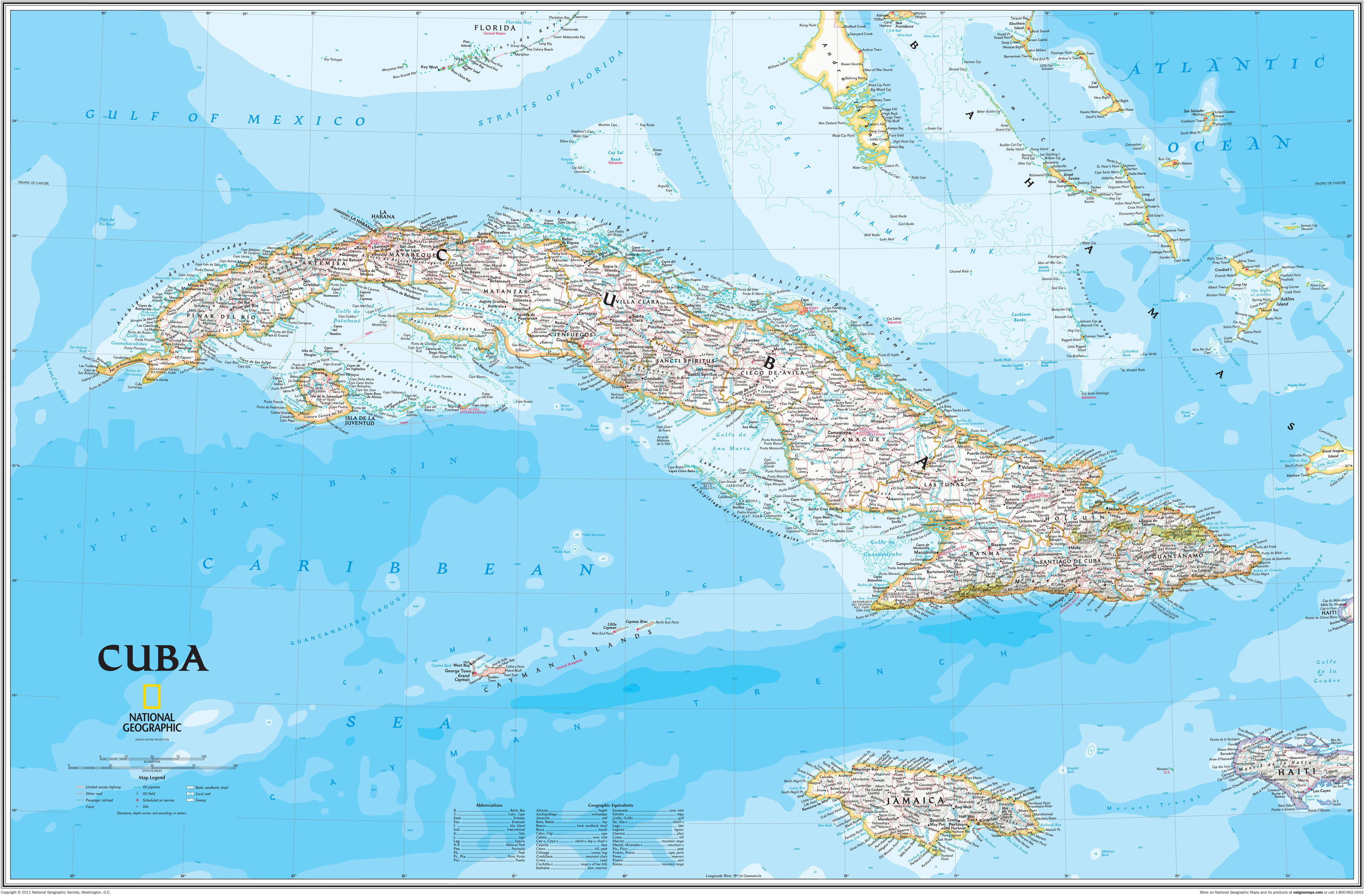
"Last July, the National Geographic Society released its first comprehensive map of Cuba in more than 100 years. The new, detailed map includes two new Cuban states and is worthy of recognition in its own right — but the real story is the cartographer behind the project. Cartographer and geographer Juan Jose Valdes fled Cuba for the United States when he was a young boy. Today, he's not just any geographer, but the geographer at National Geographic. In a special broadcast in front of a live studio audience, Valdes explains the features of the new map of his homeland and what it meant to him to create it. (Click here for a closer look of Valdes' map of Cuba.)" A new book has just been realized by Ken Jennings. Below is the summary of the book taken from Ken Jennings website.
"Maphead: Charting the Wide, Weird World of Geography Wonks is Ken's followup to his 2005 best-seller Brainiac. Much as Brainiac offered a behind-the-scenes look at the little-known demimonde of competitive trivia buffs, Maphead finally gives equal time to that other downtrodden underclass: America's map nerds. In a world where geography only makes the headlines when college students are (endlessly) discovered to be bad at it, these hardy souls somehow thrive. Some crisscross the map working an endless geographic checklist: visiting all 3,143 U.S. counties, for example, or all 936 UNESCO World Heritage Sites. Some pore over million-dollar collections of the rarest maps of the past; others embrace the future by hunting real-world cartographic treasures like "geocaches" or "degree confluences" with GPS device in hand. Some even draw thousands of their own imaginary maps, lovingly detailing worlds that never were. Ken Jennings was a map nerd from a young age himself, you will not be surprised to learn, even sleeping with a bulky Hammond atlas at the side of his pillow, in lieu of the traditional Teddy bear. As he travels the nation meeting others of his tribe--map librarians, publishers, "roadgeeks," pint-sized National Geographic Bee prodigies, the computer geniuses behind Google Maps and other geo-technologies--he comes to admire these geographic obsessives. Now that technology and geographic illiteracy are increasingly insulating us from the lay of the land around us, we are going to be needing these people more than ever. Mapheads are the ones who always know exactly where they are--and where everything else is as well." "Maps for Change is an organization dedicated to empowering people with GIS skills to be practitioners and volunteers by bringing people with GIS skills and NGOs together.
Maps for Change includes both students that are seeking practical opportunities for their GIS classes as well as GIS professionals from around the world. " If you are a student looking for some practical GIS experience, check out this opportunity. https://sites.google.com/site/mapsforchange/ By Jane Lindholm, Produced by Ric Cengeri
There was a time when geography was memorizing chief crops, major bodies of water and picking out countries on a map. Knowing that cloves came from places like Zanzibar and Madagascar or locating the Caspian Sea seemed all there was to this study. Not today. Anne Knowles, a geography professor atMiddlebury College, is using geographic information systems (GIS) to learn more about the Civil War and the Holocaust. St. Michael’s College professor Richard Kujawa is looking at the public benefit of conservation easements and the complex relationships that tie places together. We look at geography in the 21stcentury with both of them. Plus, Vermont will get a new Supreme Court justice in the coming year as Denise Johnson steps down. Vermont Law School Professor Cheryl Hanna explains the process and the pressure on judges throughout Vermont's court system.And we hear a recitation from Vermont’s reigning Poetry Out Loud champion Claude Mumbere of Burlington High School. The competition is a national project supported by the Poetry Foundation and the National Endowment for the Arts. Claude recently represented the state at the national competition in Washington D.C. Click here to listen to the podcast. Summary: Directions Magazine surveyed selected state and local government geospatial technology officials to get their input on the current outlook for jobs. Some states are cutting budgets and we wanted to see how this has impacted hiring or expansion in GIS departments.
Click here to read the full article. |
Categories
All
Archives
March 2024
|
 RSS Feed