CHRISTINA FRIEDLE

Geospatial Jobs, Internships, events, news & More

  • Home
  • About Me
  • Courses
  • GIS Club
    • About Us
    • Don't be a Dangle!
    • Event Calendar
  • Resources
    • Data
    • Tools
    • Blogs
    • ArcGIS Install
  • Blog
  • Aventuras Colombianas

4/6/2021

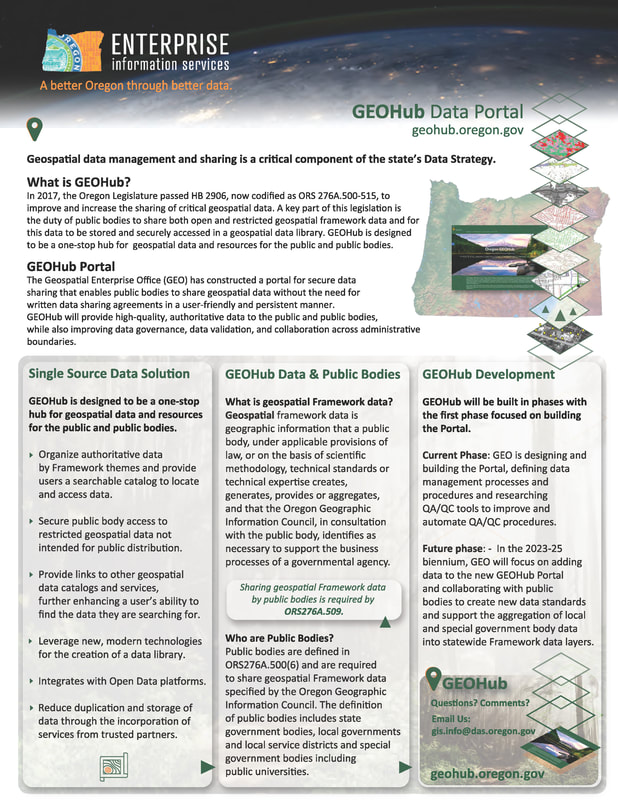
Open Data Webinar Series: The Open Data Coordinator/Health and Human Services Policy Area Spotlight

0 Comments

Read Now
 
The Open Data Webinar series will continue into the month of April. The second Open Data Webinar in our series will focus on the Open Data Coordinator role and expectations, along with a focused open data spotlight on use cases within the Health and Human Services topic area.
Picture

Share

0 Comments

11/2/2020

Oregon Wildfire Response and Recovery Site Announcement

0 Comments

Read Now
 
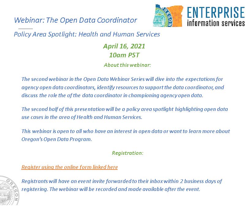
The State of Oregon has a new site that we recently launched indicating statistics and information about the wildfires that have occurred this year. On this new site, you will find the following information:
  • Hazardous debris removal status
  • Damage assessment figures
  • Fire statistics
  • Shelter statistics
  • Evacuation history
  • Fires story map (showing pictures/videos/maps/images of the impacts from the event and recovery status)
  • Individual assistance registrations by county
  • External outreach centers (found under the recovery tab)
 
Clicking on any of the main cards will take you to the relevant page for that information. Additionally, you have the ability to access key topics by using any of the main links on the top of the page.
Picture
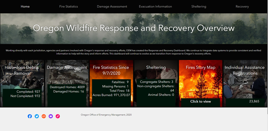
This information is being automatically updated based upon available data and will change as we get updates from our partners.
 
You can access this new page here: https://arcg.is/0e4yy9. It is also linked on our wildfire.oregon.gov website. 

Share

0 Comments

2/20/2020

DOGAMI Lidar Services

0 Comments

Read Now
 
DOGAMI has done a major overhaul of their lidar viewer.  They also added more lidar data to the services.  And in an effort to clean up and organize, they have moved all lidar related services to this directory:
 
https://gis.dogami.oregon.gov/arcgis/rest/services/lidar
​

Share

0 Comments

12/6/2019

Oregon Office of Emergency Management has a new public GIS data hub!

0 Comments

Read Now
 
The Oregon Office of Emergency Management is happy to announce a brand new website for you and the public to see and interact with GIS data describing current impacts to the state of Oregon. This new website includes the following in an easy-to-read format:
  • Incident statistic data about current natural hazards in our state,
  • Views of the 2D and 3D version of RAPTOR and our leadership briefing product (which includes details by hazard of current impacts),
  • Links to our disaster story maps,
  • Links to success stories using GIS for real-world events,
  • Mapping related videos (from our weekly watch products and other informational videos), and
  • Links to explore hazard data to add it to your own mapping applications.
 
To check out this new website, please go to: https://oregon-oem-geo.hub.arcgis.com/. We have also updated our OEM website to link to this page directly from the RAPTOR and GIS link on our default website (https://oregon.gov/oem).

Share

0 Comments

9/19/2019

Oregon Census Data Users Conference (Oct 1- 3)

0 Comments

Read Now
 
The PSU Population Research Center presents the annual
Oregon Census Data Users Conference

Tuesday, October 1, 2019 in Salem
Wednesday, October 2, 2019 in Redmond
Thursday, October 3, 2019 in Portland

The conference is free to the public. However, advance registration is required.  A registration form with agendas for each day, speaker bios, and information about a live stream are at: 

https://www.pdx.edu/prc/events  

Agendas are similar each day, so please register for one of the locations for either the morning or afternoon session, or both sessions.

Topics include:
  • data.census.gov Training
  • Census API and Data Visualizations
  • Oregon Prepares for the 2020 Census
  • New Privacy measures for the 2020 Census
  • 2020 Census Data Products

For more information, or if you prefer to register by email, contact Charles Rynerson, rynerson@pdx.edu

If there are others who should know about these workshops, please share this information with them.

Share

0 Comments

8/21/2019

OSIP 2018 orthoimagery (western Oregon)

0 Comments

Read Now
 
The 2018 western Oregon 1ft orthoimagery is finally available! We'll be updating all the supporting Web pages as soon as we can but wanted to let everyone know that they can start streaming the data now.

You can access Web Services to stream the OSIP 2018 imagery from the REST endpoint URL here:
https://imagery.oregonexplorer.info/arcgis/rest/services

Instructions for consuming Web Services (REST & WMS) can be found here:
https://oregonexplorer.info/content/web-services-stream-imagery?topic=119&ptopic=98
(That page will be updated with direct links to the OSIP 2018 data soon.)

Direct download of the imagery is not available. Copies of the data are being provided on request through the Oregon Geospatial Enterprise Office by contacting David Mather, david.mather@oregon.gov.

Share

0 Comments

10/17/2018

Updates to Oregon's imagery services

0 Comments

Read Now
 
The Oregon Statewide Imagery Program (OSIP) is pleased to provide this advance notice of upcoming changes to Oregon's imagery web services!

The planned Go Live date is October 31st.

Please review the following information and plan accordingly, especially if your web applications or workflows include web services from http://imagery.oregonexplorer.info/arcgis/rest/services

We will be adding:
  • OSIP's 2017 1-ft eastern Oregon imagery
  • Statewide NAIP imagery from 2012, 2014, 2016

We will be removing:
  • Dedicated Near Infrared (IR) services, but including the IR band in all dynamic services when available
  • All Lidar derived services, but access are available through DOGAMIhttps://gis.dogami.oregon.gov/maps/lidarviewer/
​
For a detailed discussion of what web services have been added and removed, including changes to the Oregon Imagery Explorer, please review the FAQ document available from OSIP's Data web page
For information about the Oregon Statewide Imagery Program visit: https://www.oregon.gov/geo/Pages/imagery.aspx
For information on the various vintages of imagery available visit: https://www.oregon.gov/geo/Pages/imagery_data.aspx

Share

0 Comments

8/21/2018

Oregon Census Data Users Conference 9/13 in Portland

0 Comments

Read Now
 
Registration is now open for the annual Oregon Census Data Users Conferences on Wednesday, September 12th in Salem and Thursday, September 13th in Portland.  

There will be plenty of capacity in both Portland and Salem, so you are welcome to attend part or all of the day, depending on your schedule and interests. You can find a rough agenda at https://www.pdx.edu/prc/events and below.  More details and specific times will be added at that link.

The link to register is https://goo.gl/forms/URzUFR6REeBUTduB3. 

​Morning:  9:00 am-noon.  Rural issues and New Data Tools.

  • What is Rural?  An Overview of Urban/Rural Geographies and Classifications. Jennifer Zanoni, Geographer, Geographic Standards, Criteria, and Quality Branch (GSCQB), Geography Division, U.S. Census Bureau
  • An Emerging Contradiction:  Nonfarm Activity within Exclusive Farm Use Zones. Nicholas Chun, Population Estimates Program Manager, Population Research Center, PSU.
  • New data tool:  data.census.gov. TBD, Center for Enterprise Dissemination Services and Consumer Innovation CEDSCI, U.S. Census Bureau.
Afternoon: 1:00-3:30 pm.  Census Bureau Updates and 2020 Census
  • Census Bureau Updates. Heidi Crawford, Data Dissemination Specialist, Customer Liaison & Marketing Services Office, U.S. Census Bureau.
  • Road to Census 2020 – Ensuring an Accurate and Complete Count.  Charmaine Ramos, Tribal Partnership Specialist, Los Angeles Regional Office, US Census Bureau.

Share

0 Comments

7/2/2018

Building Footprint data - open data from Bing/Microsoft

0 Comments

Read Now
 
See the recent announcement from Bing/Microsoft about creating 125 million buildings' footprint data and releasing it as open data.

https://blogs.bing.com/maps/2018-06/microsoft-releases-125-million-building-footprints-in-the-us-as-open-data/

Share

0 Comments

10/11/2017

DOGAMI Launches New Lidar Data Viewer

0 Comments

Read Now
 
The Oregon Department of Geology and Mineral Industries has launched the Lidar Data Viewer interactive map, which offers additional data and new features that make exploring and downloading lidar easier than ever before.
 
Visit the viewer: https://gis.dogami.oregon.gov/lidarviewer/
 
Since the Oregon Lidar Consortium (OLC) was formed in 2007, DOGAMI has collaborated on collection of lidar data with more than 80 partners. The viewer offers OLC data for free download, and now includes data from 18 recent OLC projects.
 
The newly available data includes:
  • Lane County: 3,226 square miles. Covers portion of Douglas, Lane, Deschutes, Benton, Linn, Jefferson, Lincoln and Marion County.  Consortium members include Lane County, City of Eugene and Springfield, Emerald People’s Utility District, Lane Council of Governments, Weyerhaeuser as well as Bureau of Land Management and the USGS.
  • Metro: 1,240 square miles. The Metro project was a lidar and imagery collection that brought together over 30 different regional, local and state agencies that needed new elevation data covering the Portland Metro region. The project covers a small portion of Clatsop, Columbia, Hood River, Yamhill and Marion County as well as large portions of Washington, Multnomah and Clackamas County.
  • Clackamas: 709 square miles. Covers portions of Clackamas and Marion County. The project was funded by USGS, National Resource Conservation Service (NRCS), Bureau of Land Management, Weyerhaeuser and Portland General Electric.
  • Ochoco West: 474 square miles. Covers portion of Crook County. The data was supported by contributions from USDA Forest Service.
  • And data from OLC projects: Green Peter, Big Windy 2013 and Big Windy 2015, Crooked Ochoco, Scappoose, Umatilla YST, Lower Malheur, Panther Creek 2015, Wasco, Four Rivers, Harney Basin, Wallowa 3DEP, Upper Rogue 3DEP, and Upper Umpqua 3DEP. 
 
For more information about the Lidar Data Viewer or the Oregon Lidar Consortium, contact:
Jake Edwards
Oregon Lidar Consortium Coordinator
jacob.edwards@oregon.gov 
971-673-1557

Share

0 Comments
<<Previous
Details

    Archives

    December 2021
    November 2021
    October 2021
    September 2021
    August 2021
    July 2021
    June 2021
    May 2021
    April 2021
    March 2021
    February 2021
    January 2021
    December 2020
    November 2020
    October 2020
    September 2020
    August 2020
    July 2020
    June 2020
    May 2020
    April 2020
    March 2020
    February 2020
    January 2020
    December 2019
    November 2019
    October 2019
    September 2019
    August 2019
    July 2019
    June 2019
    May 2019
    April 2019
    March 2019
    February 2019
    January 2019
    December 2018
    November 2018
    October 2018
    September 2018
    August 2018
    July 2018
    June 2018
    May 2018
    April 2018
    March 2018
    February 2018
    January 2018
    December 2017
    November 2017
    October 2017
    September 2017
    August 2017
    July 2017
    June 2017
    May 2017
    April 2017
    March 2017
    February 2017
    January 2017
    December 2016
    November 2016
    October 2016
    September 2016
    August 2016
    July 2016
    June 2016
    May 2016
    April 2016
    March 2016
    February 2016
    January 2016
    December 2015
    November 2015
    October 2015
    September 2015
    August 2015
    July 2015
    June 2015
    May 2015
    April 2015
    March 2015
    February 2015
    January 2015
    December 2014
    November 2014
    October 2014
    September 2014
    August 2014
    July 2014
    June 2014
    May 2014
    April 2014
    March 2014
    February 2014
    January 2014
    December 2013
    November 2013
    October 2013
    September 2013
    August 2013
    July 2013
    June 2013
    May 2013
    April 2013
    March 2013
    February 2013
    January 2013
    December 2012
    November 2012
    October 2012
    September 2012
    August 2012
    July 2012
    June 2012
    May 2012
    April 2012
    March 2012
    February 2012
    January 2012
    December 2011
    November 2011
    October 2011
    September 2011
    August 2011
    July 2011
    June 2011
    May 2011
    April 2011
    March 2011
    February 2011
    January 2011
    December 2010
    November 2010
    October 2010
    September 2010
    August 2010
    July 2010
    June 2010
    May 2010
    April 2010
    March 2010
    February 2010
    January 2010
    December 2009
    November 2009
    October 2009
    September 2009
    May 2009
    April 2009

    Categories

    All
    Aag
    Americorps
    Animations
    Applied GIS
    Applied Gis
    Apps
    Article
    Articles
    Asprs
    Books
    Careers
    Cartography
    Competition
    Conferences
    Conservation
    Diaster Mapping
    Drones
    Environmental
    Esri
    Events
    Fellowships
    Games
    Geoapp
    Geographic Awareness
    Geography
    Geomatics
    Geospatial Technologies
    GIS
    GIS Data
    Gis Data
    GIS Day
    GIS Day
    GIS Resources
    Gis-resources
    Google
    Google Earth
    Google Maps
    Gps
    Graduate School
    Grants
    Happy Hour
    Happy Hours
    Humor
    Hydrology
    International
    Internships
    Interviews
    Job
    Jobs
    Journals
    Lecture
    Lidar
    Maps
    Meeting
    National Geographic
    Natural Resources
    Open Source
    Oregon
    PCC
    Podcast
    Porland
    Portland
    Presentations
    Professional Development
    Professional-development
    Projections
    Raster
    Remote Sensing
    Research
    Scgis
    Scholarships
    Social Networks
    Software
    Songs
    Story Maps
    Study Abroad
    Technical Help
    Tools
    Training
    UAS
    UAV
    University
    Urban Design
    Videos
    Visualization
    Webinar
    Web Mappping
    Websites
    Women In GIS
    Workshops

    RSS Feed

Contact ME

  • Home
  • About Me
  • Courses
  • GIS Club
    • About Us
    • Don't be a Dangle!
    • Event Calendar
  • Resources
    • Data
    • Tools
    • Blogs
    • ArcGIS Install
  • Blog
  • Aventuras Colombianas