CHRISTINA FRIEDLE

Geospatial Jobs, Internships, events, news & More

  • Home
  • About Me
  • GIS Club
    • About Us
    • ASPRS Membership
  • Blog

4/29/2022

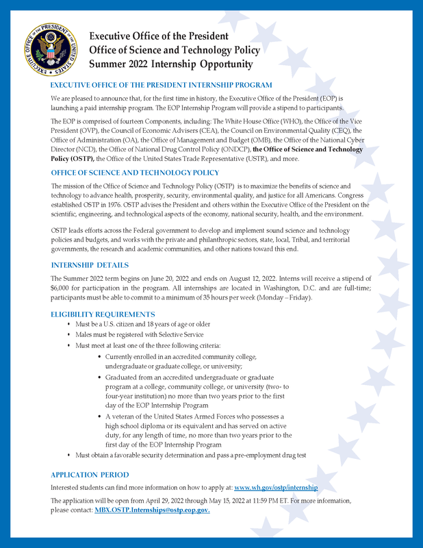
Office of Science & Technology Summer Internship Program w/ Executive Office of the President (Washington DC)

0 Comments

Read Now
 
Picture

Share

0 Comments

4/26/2022

GIS Specialist w/ US Bureau of Reclamation (Boise, ID)

0 Comments

Read Now
 
https://www.usajobs.gov/job/649887200

​
Reclamation is seeking a career professional looking for an opportunity to capitalize on their expertise as a GIS Specialist. Make a difference in the West by assisting in meeting increasing water demands while protecting the environment.

​Duties

Duties listed are at the full performance level GS-11:
  • Uses GIS and Global Positioning System (GPS) software to construct and manage geospatial data in support of several divisions and programs in the USFO.
  • Responsible for providing technical expertise in the planning, design, acquisition and maintenance of a wide range of GIS/GPS data to support resource management projects and major planning efforts.
  • Performs complex geographic analyses and uses data modeling techniques to identify interrelationships among data
  • Responsible for producing both electronic and hard copy output including, but not limited to, maps, charts, and reports.- The incumbent creates geospatial data from a variety of sources including but not limited to realty transaction documents, scanned plat pages, legislative orders, CAD drawings, etc.
  • Instructs and supports Reclamation personnel to ensure that correct data collection and processing procedures are followed and performed during collection and processing of GPS data.

Share

0 Comments

4/26/2022

GIS Analyst w/ Quil Ceda Village (Marysville, WA)

0 Comments

Read Now
 
https://www.quilcedavillage.org/Base/File/GIS-Analyst-QCV-ATS-2019-191

The GIS Analyst performs duties in the development and maintenance of Tulalip Tribes’ Enterprise GIS, which supports the GIS needs of all tribal departments. Responsibilities include web application development, multiuser geodatabase design and management, custom map production, and geospatial analysis. It requires advance knowledge of GIS concepts and products, as well as GIS dataset types and formats. This position will also conduct data collection field work using unmanned aerial vehicles, GPS, and GPR equipment.

​EDUCATION:

Bachelor’s degree in GIS, Information Technology, Computer Science, Engineering, Geography, or related field; OR two plus years of college education with a GIS Certificate from accredited school; experience may be considered as a substitute for the above education. (Upload or attach copy of degree or transcript with application).

KNOWLEDGE AND ABILITIES
  • urrent GIS technologies (including hardware, software, and handheld tools) and industry trends
  • Analytical, problem-solving, and troubleshooting skills
  • Visual communication and data mapping theories
  • GIS application development, programming (Python, JavaScript), and/or GIS related technologies
  • GIS production of complex cartographic and other spatial data displays
  • GIS web-mapping applications served to internal and external users
  • Project management, planning, organization, and customer service skills
  • Database techniques to process and analyze geo-spatial datasets
  • SQL Database administration in support of geodatabases
  • Scientific research and data collection techniques
  • User Acceptance Testing, metadata, hardware/software configurations, and GIS standards

ABILITY TO
  • Communicate effectively by oral, written, and by other graphical means
  • Read, understand, and apply technical manuals and procedures
  • Maintain required records and prepare necessary reports
  • Independently analyze problems and assist others in GIS analysis
  • Apply critical thinking and problem-solving skills to business needs
  • Learn new programs, platforms, and tools to finish specific analysis and tasks
  • Complete multiple competing projects and meet deadlines
  • Effectively function as a team member
  • Analyze customer needs and business systems
  • Convey technical information to non-technical users
  • Administer geodatabases in a MS SQL environment
  • Train users in GIS products and promote GIS solutions
  • Work with a variety of individuals from diverse backgrounds
  • Understand disciplines of other department and entities

EXPERIENCE:

One (1) or more years of full-time work experience using ESRI software as GIS Analyst, GIS Specialist or GIS Technician. This experience must include extensive time creating maps and web map applications, geoprocessing, and database management.

LICENSE AND OTHER REQUIREMENTS:
  • Valid Washington State Driver’s License or ability to obtain one within 2 months of start date (Required – please attach copy to application form).
  • Valid FAA Part 107 Remote Pilot Certificate or ability to obtain one with 6 months of start date.
  • Must have no misuse of drugs and/or alcohol within two (2) years prior to employment or while
    employed.
  • Must have excellent attendance record and no attendance disciplinary actions with in the last six (6) months.
  • Must have no history of suspension, last chance agreement or dismissal with in the last (6) months.
  • Must have a successful employment history with the Tulalip Tribes or other employers.

PHYSICAL CHARACTERISTICS AND/OR PREREQUISITES:


ENVIRONMENT

Work is performed in an office environment with some field trips to locations in and around the Tulalip Reservation for the purpose of data collection and fieldwork.

PHYSICAL DEMANDS
  • Manual and finger dexterity for the operation of personal computer, office machines and routine
    paperwork.
  • Hearing and speaking to exchange information.
  • Seeing to view a computer monitor and read a variety of maps and documents, tolerance to be exposed to computer screen for prolonged periods.
  • Stamina to sit, stand and/or walk for prolonged periods in any weather condition in outdoor terrain while carrying equipment and supplies during field studies.
  • Mobility to bend, stoop, and/ or climb stairs.
  • Ability to lift objects weighing up to 50 lbs.

ESSENTIAL DUTIES
  • GIS data collection (including fieldwork), geodatabase development, geodatabase maintenance, geodatabase administration, data conversion, digitization, data editing and integration, and other database administration duties.
  • Produce wide array of GIS products including cartographic maps, map books, web maps, electronic files, web pages and REST services.
  • Spatial analysis, 3D analysis, data modeling, scripting, and reporting.
  • Design, develop, implement, and maintain custom GIS and web map applications using Web AppBuilder, Python, and JavaScript.
  • Operate and support various software applications including: ArcGIS Desktop 10.x (Required), ArcGIS Pro (Preferred), ArcGIS for Server 10.x (Preferred), Web AppBuilder (Preferred), MS SQL Server (Preferred).
  • Create documentation to describe the data (metadata), program development, logic, coding, and corrections
  • Troubleshoot errors others encounter while using ArcGIS.
  • Contributes to and leads projects by reviewing existing data, recommending data needs, accessing available digital data from other sources, and determines analyses to fulfill project requirements.
  • Work with GIS staff and other tribal department staff on various extended fieldwork projects.
  • Perform routine maintenance of GIS-related hardware such as mapping grade GPS devices, plotters, scanners, PC, laptops, tablets, and other devices and tools.
  • Communicate positively with internal and external customers to address their needs promptly, and following through on commitments.
  • Detailed evaluations of existing and proposed systems and related operational procedures, and
    recommend necessary changes.
  • Utilize computer technology to perform research, analyze and transfer data, write reports, and present data and documentation.

OTHER DUTIES
  • Perform related duties as needed and assigned.

TERMS OF EMPLOYMENT:

This is a Regular Full-time position, requiring at least 40 hours per week, or 2080 hours per year. Employee may be required to work after hours, weekends, special events and/or on call. Upon successful completion applicable probationary period employee may be eligible for an increase in pay, subject to budgetary restriction. Employees will be required to work on-site, no telecommuting. No provisions for relocation will be provided.

​Disclaimer: The information provided in this description has been designed to indicate the general nature and level of work performed by incumbents within this job. It is not designed to be interpreted as a comprehensive inventory of all duties, responsibilities, qualifications and working conditions required of employees assigned to this job. Management has sole discretion to add or modify duties of the job and to designate other functions as essential at any time. This job description is not an employment agreement or contract.

Share

0 Comments

4/26/2022

GIS Analyst II w/ Eugene Water & Electric Board (Springfield, OR)

0 Comments

Read Now
 
https://recruiting.ultipro.com/EUG1001EWEB/JobBoard/23d62d3c-f909-4124

This posting opens Friday, April 22, 2022, and will close Friday, May 6, 2022, at 3:00 p.m. PST. We recommend you get your application in as soon as possible.

​The Eugene Water & Electric Board is currently seeking a GIS Analyst II to support watershed restoration projects on the McKenzie River. GIS analysis and support is critical to the drinking water source protection program and watershed restoration work associated with the Pure Water Partners program (PWP) that involves revegetation, hazard fuels treatments, invasive weed control, installation of erosion control BMPs, and riparian restoration.
The successful candidate will perform complex work related to GIS which includes: GIS Workflow Analysis and Process Design, Solution Development and Implementation, Data Management, GIS and other Support Systems, Programming, Report Development, Analysis, Software Troubleshooting and Testing, Training, Documentation, and Project/Task Management.

This job has a broad range of responsibilities. Specific duties will vary, and they may change as necessary to meet business and program needs.

Specific duties include:
  • Produce custom paper, pdf, and web-based cartographic products.
  • Work with stakeholder to understand business needs and develop GIS-centric workflows.
  • Document processes, business needs, and project plans.
  • Support and train staff who use GIS.
  • Troubleshoot systems, tools, and processes.
  • Perform GIS analysis and spatial modeling.
  • Administer content in ArcGIS Online, ArcGIS Portal, and other systems.
  • Design GIS databases, tools, maps, and apps.
  • Implement new software and/or tools.
  • Create reports using SQL or other tools.
  • Ensure data and product quality by following and developing QA/QC processes.

The successful candidate will have knowledge of and direct experience with:
  • ESRI ArcGIS software including ArcGIS Portal/Enterprise, SDE, and Geometric/Utility Networks.
  • ESRI mobile applications such as ArcGIS Field Maps, Workforce, Insightly, and Survey 123
  • Schneider ArcFM software
  • Geocortex software
  • Water utilities and watershed management
  • GIS tools for Analysis and Reporting
  • Scripting languages such as SQL, Python, and Arcade.
  • Mobile apps and web-based GIS tools and processes.
  • Project intake and requirements gathering.
  • Customer service
  • Technical writing
The starting annual salary for this position is commensurate with knowledge, skills, education, and experience as it relates to the position. The hiring range for the GIS Analyst II position is $73,468.32 to $91,835.52.

Please note:
 This posting includes supplemental questions. Your responses will be scored and used to determine if you will proceed to the next step of the selection process. Please provide detailed answers to each question. Please do not reference your resume or application in your responses. Applications may be rejected if incomplete.
This position is based in Eugene, Oregon; however, it has been approved as a hybrid telecommuting arrangement involving a combination of telecommuting and working on-site on a less frequent basis. EWEB is committed to the safety of the workforce, therefore on-site visits may be reduced based on CDC/OHA guidelines due to COVID-19.

WORKING AT EWEB

EWEB values total worker health both at work and at home, and provides a robust compensation & benefits package – Read more about our benefits.

Why EWEB?

EWEB offers employees a progressive work culture devoted to providing excellent public service. Our employees work in a fast-paced environment where creativity, innovation, involvement, teamwork, and professional development are supported and encouraged. EWEB is also committed to providing a work environment conducive to the safety, health, and well-being of its workforce, and offers great benefits, including but not limited to health care, vacation and sick leave, pension, holidays, and employee credit union. We are currently one of the top three healthiest employers in Oregon and consistently rank within the top 100 healthiest employers in the nation!
Founded in 1911, EWEB is Oregon's largest customer-owned utility. We provide water and electricity to the Eugene community, as well as parts of east Springfield and the McKenzie River valley area.

As a public utility, we do not operate to earn a profit or to serve the investment needs of stockholders. Instead, EWEB is chartered by the City of Eugene to serve the interests of its citizens. We are owned by the people of Eugene and it's our job to provide reliable, affordable water and electricity for our customers.

Our mission is to enhance our community's vitality by delivering drinking water and electric services consistent with the values of our customer-owners. And our vision is to do so while being a local utility that inspires our customers to invest in and rely on us.

Our core values:
  • SAFETY: We value the physical and psychological health and safety of our workforce and the public.
  • RELIABLITY: We value the continuous, on-demand delivery of quality drinking water and electricity.
  • RESPONSIBLITY: We value the prudent and sustainable stewardship of our customers' financial and natural resources, including our impact on affordability and role in reducing the greenhouse gases (GHGs) contributing to climate change.
  • COMMUNITY: We value our local governance and obligation to transparently serve our community.

Why Eugene?

It’s a city big enough to boast excellent restaurants, arts, and events, but small enough to still feel like a community. It’s also easy to get out of town, making it an ideal place for lovers of outdoor activities, with world-class opportunities for fishing, rafting, bicycling, hiking, and camping. The city is just an hour to the Cascades Mountains or to the Oregon Coast, but you don’t have to leave Eugene to find nature. The Willamette River runs through the middle of the city and there are parks and trails throughout Eugene. Home to the University of Oregon, Eugene is proud to have hosted the 2021 Olympic Track and Field Trials and the 2022 Track and Field World Championships. Whatever you’re looking for, you can find it here!

Equal Employment Opportunity

EWEB takes pride in our commitment to diversity and inclusion among our employees. We embrace and value differences of culture, education, experience, physical ability and unique perspectives in our workplace. We invite applications from qualified candidates who share our commitment to diversity. Attracting, retaining and advancing talent from all sources strengthens our bond with the multifaceted community we serve.

Tobacco, Smoke, and Vapor - Free Campus Policy

EWEB fosters an environment promoting good health for both employees and the public. We want to enhance the quality of air, appearance, and employee health in and around EWEB facilities and equipment. Employees, contractors, volunteers, and visitors may not use, distribute, or sell tobacco while participating in EWEB functions, on EWEB property, or while performing right-of-way tasks.

MINIMUM TRAINING AND EXPERIENCE REQUIRED:

GIS Analyst II: Four years of GIS experience in a support capacity including experience using ESRI ArcGIS software and cartographic experience.
Education: Bachelor’s degree Geography, Computer Science, Engineering, Business, or related field with specific GIS coursework and/or training.
Desirable education, experience and training: Experience working in watershed restoration and linear networks highly preferred.
Equivalency: An equivalent combination of experience and education may be qualifying.

Share

0 Comments

4/26/2022

GIS Professional w/ Haley & Aldrich (pdx)

0 Comments

Read Now
 
https://haleyaldrich.csod.com/ux/ats/careersite/1/home/requisition/1013?c=haleyaldrich

At Haley & Aldrich, our goal is to deliver exceptional service to our clients and our communities. And we know that to do so, we need diverse and unconventional thinkers. That’s why we foster a culture that provides collaboration, flexibility, and support – so our staff can bring their unique value to bear and explore the areas they’re passionate about. 

Are you looking to work in an environment where you can be your authentic self and work on projects that are meaningful to you?

Haley & Aldrich is seeking a highly motivated and technically capable GIS professional to join our Data, Visualization, and Design practice. We collaborate closely with our colleagues and clients on challenging projects in the fields of environmental geology, geotechnical engineering, risk assessment, natural resource management, permitting, and sustainability.

DUTIES/RESPONSIBILITIES
The successful candidate will:
  • Work with project teams to determine the optimal approach for using geospatial technologies to meet project needs, accurately estimate the corresponding level of effort, and then see implementation through to completion.
  • Approach each task, regardless of size and scope, as an opportunity to rethink the conventional ways data is collected, managed, visualized, and delivered.
  • Produce concise, clear, and compelling cartographic output with a keen eye for aesthetics.
  • Balance a high level of creativity with adherence to established company GIS standards and best practices.
  • Always be persistent and diligent about quality, both in one’s own work and the work of others.
  • Actively engage in the greater GIS community, both locally and beyond, staying aware of the state of practice, new tools and technology, and opportunities for growth.

SKILLS/EXPERIENCE
  • BS/BA degree
  • Two to ten years’ experience as a GIS professional
  • Experience in building and using a GIS to solve problems, present results, and graphically report analytical data
  • Advanced skills using Esri ArcGIS for Desktop and ArcGIS Pro
  • Experience developing web GIS using ArcGIS Enterprise/Portal, ArcGIS Online, and/or Geocortex
  • GIS-CAD data interoperability and integration skills
  • Strong written and oral communication skills for all levels of technical understanding
  • Enthusiasm, dedication, and self-discipline in order to work effectively in an exciting, diverse, and fast-paced environment
  • Candidates will be required to provide a portfolio of their work

PREFERRED QUALIFICATIONS
  • Mobile data collection, processing, and integration (Field Maps, Collector, Survey123)
  • Database management and analytics (Power BI, EQuIS, OpenGround, SQL Server)
  • Automation and ETL (FME, Python, Model Builder)
  • UAS data acquisition and processing (Pix4Dmapper or Agisoft Metashape)
  • GISP certification

About Haley & Aldrich

Haley & Aldrich, Inc. is committed to delivering the value our clients need from their capital, operations, and environmental projects. Our one-team approach allows us to draw from our 800 engineers, scientists, and constructors in 33 offices for creative collaboration and expert perspectives. Since our founding in 1957, we have one goal in all we do: deliver long-term value efficiently, no matter how straightforward or complex the challenge. In 2020, Haley & Aldrich acquired Hart Crowser, an engineering and environmental consultancy with extensive expertise in the Pacific Northwest and recognized for its cutting-edge performance-based seismic design methods. Visit www.haleyaldrich.com.

Haley & Aldrich is an Equal Opportunity Employer. All qualified applicants will receive consideration for employment without regard to gender, race, age, disability, veteran or any other legally protected status. We offer excellent career growth, a highly competitive total compensation plan and a solid benefits package that includes; health, dental, vision; Short-Term/Long-Term Disability; 401(k) with match; generous vacation plan and paid time off; tuition reimbursement; long-term care, and more. Interested candidates should apply online on our 
Careers page.

Share

0 Comments

4/26/2022

GIS Local Government Sector w/ FLO Analytics (pdx)

0 Comments

Read Now
 
https://floanalytics.applicantpool.com/jobs/743443.html 

GIS Local Government Sector Lead - Portland, Seattle or Remote

​FLO is searching for a GIS Local Government Sector Lead in our Portland, OR or Seattle, WA offices or working remotely. As a Local Government Sector Lead, you will help our clients use GIS to improve efficiencies in service delivery, communicate with their communities and plan sustainably for the future. In a typical day, you will: communicate with clients and staff to plan and deliver project needs, design and implement GIS solutions and projects, and implement business development strategy to grow the sector. To thrive in this role, you must have the following:
  • Proven project management experience.
  • Extensive knowledge and understanding of local government needs and demonstrated initiative and ability to drive change through consensus.
  • Highly proficient with GIS and Esri products, including ArcGIS Desktop, ArcGIS Pro, ArcGIS Enterprise, and ArcGIS Online. Experience with asset management requirements, systems, and Esri utility data models preferred.
  • Outstanding organizational and leadership abilities
  • Excellent interpersonal and public speaking skills
  • Demonstrable competency in strategic planning and business development
  • Working knowledge of data analysis and performance/operation metrics

FLO specializes in Geographic Information Systems (GIS) and data analytics services, serving government, school districts, utilities, and non-profit groups in the Pacific Northwest and nationally. FLO is a subsidiary of Maul Foster & Alongi, Inc. (MFA), an employee-owned Pacific Northwest consulting firm specializing in the areas of environmental science, engineering, planning, communications, and GIS. Come join FLO and MFA for the benefits to your career, the benefits to your community and these benefits: 
  • 100% premium coverage for your medical/dental/vision and 80% for your dependents 
  • Competitive paid time off plus nine paid holidays 
  • Comp time program for exempt employees 
  • Participation in the Employee Stock Ownership Plan 
  • 401k company match 
  • Support for your professional growth through coaching and external training support 

FLO is proud to be an equal opportunity employer. Here at FLO, we celebrate diversity and are a better company because of diverse experiences and perspectives. We are committed to being an inclusive environment for all employees. Employment decisions are based on job requirements, business needs, and individual qualifications. All qualified applicants will receive consideration for employment without regard to race, color, religion, sex, sexual orientation, gender identity, national origin, age, disability, marital status, military service or any other status protected by laws and regulations.


Share

0 Comments

4/26/2022

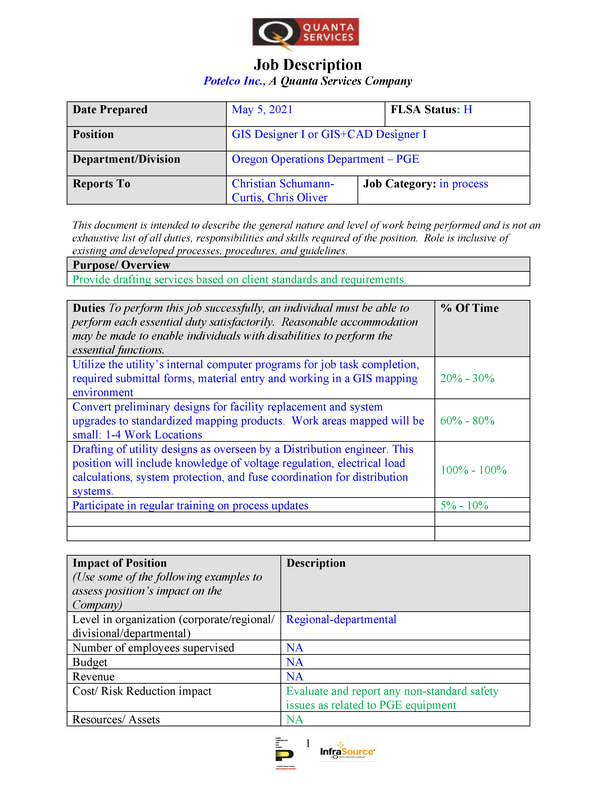
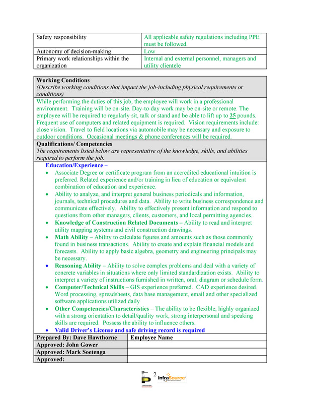
2 or 3 positions: GIS Designer 1 or GIS + CAD Designer 1 w/PGE (Pdx)

0 Comments

Read Now
 
Picture
Picture
Contact:

Christian Schumann-Curtis
GIS Lead
Portland General Electric | Potelco Inc
7am-5.30pm, Monday thru Thursday
O: 503.718.6318
C: 503.774.3568
christian.schumann-curtis@pgn.com

Dave Hawthorne | Contract Design Supervisor
Potelco Inc |Portland General Electric
3700 SE 17th Ave. | Portland, OR 97202
253-405-7888 | dave.hawthorne@pgn.com

Share

0 Comments

4/24/2022

GIS Analyst w/ City of Florence (OR)

0 Comments

Read Now
 
The City of Florence, Oregon is located on the Central Oregon Coast about 1 hour from Eugene. The City is looking for a full-time, on-site, GIS Analyst, which has a hiring pay range of $21.64 to $24.53/hr. The determination of the position and pay will depend upon the applicant’s qualifications. This a 40 hour per week position that comes with employer paid medical premiums, health savings account, and is part of the Public Employee Retirement System.

​To apply or learn more about the position, visit https://www.governmentjobs.com/careers/florenceor and select the GIS Analyst position. 

If you are interested in local government, have experience in Geographic Information Systems, and are eager to take on new tasks, then this position is a great opportunity to continue your career with us!

Share

0 Comments

4/24/2022

Virtual Summer Series through Association of American Geographers (AAG)

0 Comments

Read Now
 
Registrations are open for the AAG 2022 Virtual Summer Series, which strives to guide current and recent geography students through their academic and professional journeys, and connect them with new peers. 
The series will feature different event types between May and August, namely workshops, seminars, working groups, and forums. Each event type has a different format (some are just one session, some are a week long, and some meet throughout the summer). Some event types have limited seats and require an application by April 28, be sure to register soon! Other event types simply require you to sign up to be able to participate, the registrations are open throughout the summer. 
​
  • With an AAG membership, you can register for any event type at https://www.aag.org/events/2022-summer-series-for-students-and-recent-graduates/ 
  • Any questions? Contact research-during-covid@aag.org 

 
Particular events that may interest your community members (7 days left! limited seats and required an application by April 28):

For graduate students to learn GIS or related skills:
  • Novel Topics in Geoinformatics: Drones, EO, Space-Time, Deep Learning
  • Developing Open Source SpatiaLite Databases in QGIS
  • Mapping Mindfully: Community-Based Data Collection and Visualization Through a Trauma-Aware Lens
  • Communicating Geographic Research Through Interactive Web-based Dashboards and Data Storytelling
  • Historical Spatial Data Extraction and Management: Creating Stories with Maps
  • Bayesian Spatial and Spatiotemporal Modeling Using R
  • Geospatial Data Science for Social Media Analytics
  • Visualizing Uncertainty on Maps

For recent graduates (in or outside of academia), graduate students and undergraduate students to learn skills in professional development: 
  • All events under Post Graduation Essentials.

Share

0 Comments

4/22/2022

GIS Internship w/ City of Vancouver (WA)

0 Comments

Read Now
 
https://cityofvancouver.wd5.myworkdayjobs.com/COV/job/LOC0075-City-Hall---3rd-Floor/GIS-Intern_22-0112

Job Summary
Perform under supervision technical duties to support Parks, Recreation and Cultural Services Department. Create, maintain and manage GIS maps, layers, geodatabases and other records related to parks, assets and appurtenances. Provide Park planners with a high level of customer service as it relates to the mapping of park asset inventory and maintenance responsibility areas to update school-park agreement documents. Use GIS and other tools to review, update, document and communicate discrepancies and or changes to ensure correct data management. Conduct field visits to verify accuracy of as-constructed parks assets and appurtenances.

This internship is for up to 200 hours with a flexible work schedule and optional telework.

Pay rate: $23.16 - $29.65 depending on experience/qualifications.

This posting is open until filled. First application review May 4, 2022.

Job Details
​
Essential Functions:
  • Create, maintain, and manage GIS maps, layers, geodatabases, reports and other records related to parks, assets and appurtenances.
  • Perform historical research. Review and obtain historic documentation that supports park boundaries and asset inventory. Review computer/hardcopy files, aerial imagery, CAD drawings, cadastral documents, and property information system and scanned documents.
  • Maintain asset inventory. Track Park locations, assets, and appurtenances.
  • Review project site plans and conduct field visits to verify and confirm the accuracy of assets that were constructed. Field visits may consist of meeting with job site superintendents to discuss and note various issues or discrepancies that relate to asset inventories. Update/redline plans to reflect field changes and ensure that the corrected changes are reflected in the Park GIS layer. Drive a city vehicle in a safe and appropriate manner in order to travel between various assigned worksites.
  • Effectively communicate with Park planners and Public Works maintenance staff as it relates to the location and boundary of park ownership versus school district ownership,  and delineation of the respective agency maintenance responsibility areas using appropriate and available methods of communication. This may include attending in-person or Microsoft Teams meetings, sending e-mails, making telephone calls, etc.
  • Communicate with IT and Public Works GIS staff regarding the Park GIS layer. Provide proper data management and inventory tracking to improve the quality of data.

Qualifications
​
Experience and Education
  • Two years of training preferably in the area of assignment including drafting/mapping and GIS.
  •  Equivalent to two years of coursework and/or an Associate of Geomatics degree from an accredited college with major course work in GIS, civil engineering or a related field. 

Computer Skills
  • Proficiency using Environmental Sciences Research Institute (ESRI) products i.e. ArcGIS for Desktop (ArcGIS Pro 2.x or greater), and ArcSDE including editing spatial data using these tools.
  •  Knowledge of Autodesk products, AutoCAD Map 3D is preferred.
  •  Knowledge of operating GPS equipment is preferred.
  •  Intermediate skills in Microsoft Office (Excel, Word, Access, Outlook, Teams).
  •  Knowledge of database fundamentals and understanding of relational databases.

Required Licenses and/or Certifications
  • Driver’s license
  • GIS / ESRI Certification preferred

Knowledge
  • Terminology, methods, practices, and techniques of drafting and computer-aided design and GIS;
  • Principles and practices of surveying;
  • Georeferencing data in GIS using ArcGIS Pro 2.9 or higher;
  • Editing in a versioned environment using ArcGIS with ArcSDE;
  • Asset management systems;
  • Trigonometry as applied to the computation of angles, areas, volumes, distances, and traverses;
  • Construction plans and specifications;
  • Engineering maps, records, and application of computer-aided mapping and geographic information systems for records management;
  • Modern office procedures, methods and computer equipment;
  • Use of personal computers and basic software.

Abilities
  • Create visually pleasing maps using ArcGIS Pro software;
  • Use advanced GIS functionality for reporting and analysis of our utilities for planning purposes;
  • Communicate clearly and concisely, both orally and in writing;
  • Work under over-sight or guidance understanding and following written and oral instructions; work simultaneously on multiple tasks;
  • Work with CAD data in GIS using ArcGIS Pro. Bring CAD data into GIS;
  • Exercise sound judgment in the application of engineering experience and knowledge to produce accurate and quality products;
  • Exercise great attention to detail;
  • Exercise excellent customer service skills;
  • Schedule, plan and manage workload to meet project schedules;
  • Operate a personal computer and appropriate software;
  • Work in a manner consistent with the City of Vancouver’s Operating Principles;
  • Work and act as a team player in all interactions with other City employees;
  • Provide a high level of customer service at all times;
  • Project and maintain a positive image with those contacted in the course of work;
  • Develop and maintain collaborative and respectful working relationships with team members and others;
  • Consistently provide quality service;
  • Maintain regular and dependable attendance.  

This position is subject to successful completion of a pre-employment reference check, a basic criminal background check, and a driving abstract. ​

Share

0 Comments
<<Previous
Details

    Archives

    August 2023
    July 2023
    June 2023
    May 2023
    April 2023
    March 2023
    February 2023
    January 2023
    December 2022
    November 2022
    October 2022
    September 2022
    August 2022
    July 2022
    June 2022
    May 2022
    April 2022
    March 2022
    February 2022
    January 2022
    December 2021
    November 2021
    October 2021
    September 2021
    August 2021
    July 2021
    June 2021
    May 2021
    April 2021
    March 2021
    February 2021
    January 2021
    December 2020
    November 2020
    October 2020
    September 2020
    August 2020
    July 2020
    June 2020
    May 2020
    April 2020
    March 2020
    February 2020
    January 2020
    December 2019
    November 2019
    October 2019
    September 2019
    August 2019
    July 2019
    June 2019
    May 2019
    April 2019
    March 2019
    February 2019
    January 2019
    December 2018
    November 2018
    October 2018
    September 2018
    August 2018
    July 2018
    June 2018
    May 2018
    April 2018
    March 2018
    February 2018
    January 2018
    December 2017
    November 2017
    October 2017
    September 2017
    August 2017
    July 2017
    June 2017
    May 2017
    April 2017
    March 2017
    February 2017
    January 2017
    December 2016
    November 2016
    October 2016
    September 2016
    August 2016
    July 2016
    June 2016
    May 2016
    April 2016
    March 2016
    February 2016
    January 2016
    December 2015
    November 2015
    October 2015
    September 2015
    August 2015
    July 2015
    June 2015
    May 2015
    April 2015
    March 2015
    February 2015
    January 2015
    December 2014
    November 2014
    October 2014
    September 2014
    August 2014
    July 2014
    June 2014
    May 2014
    April 2014
    March 2014
    February 2014
    January 2014
    December 2013
    November 2013
    October 2013
    September 2013
    August 2013
    July 2013
    June 2013
    May 2013
    April 2013
    March 2013
    February 2013
    January 2013
    December 2012
    November 2012
    October 2012
    September 2012
    August 2012
    July 2012
    June 2012
    May 2012
    April 2012
    March 2012
    February 2012
    January 2012
    December 2011
    November 2011
    October 2011
    September 2011
    August 2011
    July 2011
    June 2011
    May 2011
    April 2011
    March 2011
    February 2011
    January 2011
    December 2010
    November 2010
    October 2010
    September 2010
    August 2010
    July 2010
    June 2010
    May 2010
    April 2010
    March 2010
    February 2010
    January 2010
    December 2009
    November 2009
    October 2009
    September 2009
    May 2009
    April 2009

    Categories

    All
    Aag
    Americorps
    Animations
    Applied GIS
    Applied Gis
    Apps
    Article
    Articles
    Asprs
    Books
    CAD
    Careers
    Cartography
    Competition
    Conferences
    Conservation
    Diaster Mapping
    Drones
    Environmental
    Esri
    Events
    Fellowships
    Games
    Geoapp
    Geographic Awareness
    Geography
    Geomatics
    Geospatial Technologies
    GIS
    GIS Data
    Gis Data
    GIS Day
    GIS Day
    GIS Resources
    Gis-resources
    Google
    Google Earth
    Google Maps
    Gps
    Graduate School
    Grants
    Happy Hour
    Happy Hours
    Humor
    Hydrology
    International
    Internships
    Interviews
    Job
    Jobs
    Journals
    Lecture
    Lidar
    Maps
    Meeting
    National Geographic
    Natural Resources
    Open Source
    Oregon
    PCC
    Podcast
    Porland
    Portland
    Presentations
    Professional Development
    Professional-development
    Projections
    Raster
    Remote Sensing
    Research
    Scgis
    Scholarships
    Social Networks
    Software
    Songs
    STEM
    Story Maps
    Study Abroad
    Surveying
    Technical Help
    Tools
    Training
    UAS
    UAV
    University
    Urban Design
    Videos
    Visualization
    Webinar
    Web Mappping
    Websites
    Women In GIS
    Workshops

    RSS Feed

Contact ME

  • Home
  • About Me
  • GIS Club
    • About Us
    • ASPRS Membership
  • Blog