|
A must read for all GIS professionals! A short quote to get you hooked: “She [Gladys West] rose through the ranks, worked on the satellite geodesy, and contributed to the accuracy of GPS and the measurement of satellite data. As Gladys West started her career as a mathematician at Dahlgren in 1956, she likely had no idea that her work would impact the world for decades to come.” Despite the ubiquity of GPS and her role in developing it, West still prefers to use a paper map when she travels. For someone accustomed to trusting their own calculations, some old habits never die. https://www.forbes.com/sites/startswithabang/2021/02/18/gps-only-exists-because-of-two-people-albert-einstein-and-gladys-west/?sh=38588e8c5864  Building geospatial infrastructure
Many visions for geospatial technology have been advanced over the past half century. Initially researchers saw the handling of geospatial data as the major problem to be overcome. The vision of geographic information systems arose as an early international consensus. Later visions included spatial data infrastructure, Digital Earth, and a nervous system for the planet. With accelerating advances in information technology, a new vision is needed that reflects today’s focus on open and multimodal access, sharing, engagement, the Web, Big Data, artificial intelligence, and data science. We elaborate on the concept of geospatial infrastructure, and argue that it is essential if geospatial technology is to contribute to the solution of problems facing humanity. https://www.tandfonline.com/doi/full/10.1080/10095020.2019.1698274 Here's an article that I thought many students and Emerging GIS Professionals would enjoy:
https://www.directionsmag.com/article/8608 27 Differences between ArcGIS and QGIS - The Most Epic GIS Software Battle in GIS History!
Read the article: https://gisgeography.com/qgis-arcgis-differences/ I am always looking for an opportunity to promote the contributions of women in Geography. Here is a great article on Zonia Baber and her early work in Geography and Geography education.
https://www.smithsonianmag.com/science/woman-who-transformed-how-we-teach-geography-180967859/ 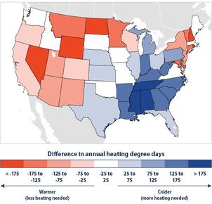 The U.S. Environmental Protection Agency (EPA) has released the third edition of a report, ‘Climate Change Indicators in the United States.’ The report presents observed data on key measures of our environment, including U.S. and global temperature and precipitation, ocean heat and ocean acidity, sea level, length of growing season, and many others. With 30 indicators that include over 80 maps and graphs showing long-term trends, the report demonstrates that climate change is already affecting our environment and our society.
The third edition of the Indicators report adds additional years of data and four new indicators: Lyme disease, heating and cooling degree days, wildfires, and water level and temperature in the Great Lakes. In addition, the report adds four new features that connect observed data records to local communities and areas of interest, including cherry blossom bloom dates in Washington D.C., timing of ice breakup in two Alaskan rivers, temperature and drought in the Southwest, and land loss along the mid-Atlantic coast. EPA compiles decades of observed data in cooperation with a range of federal government agencies, nongovernmental organizations, universities, and other institutions. The Indicators report focuses on long-term trends for key measures of our environment for which high-quality data exist. Each indicator and the report itself were peer-reviewed by independent experts, and extensive technical documentation accompanies the report. To order a FREE copy of the report, send a request with your mailing address included to climateindicators@epa.gov To find more information about the Climate Change Indicators report, or to download a PDF copy, visit http://www.epa.gov/climatechange/indicators.html  Here is an blog post, written by Joseph Kerski at ESRI, that attempts to get a handle on the size of the geospatial industry. He addresses the question as it is asked in reference to a paper someone is researching, or because someone wants to obtain a sense of the “stability” of the industry when deciding whether to pursue GIS for their career, and for some other reasons. Here is the article:
The size of the Geospatial Industry http://blogs.esri.com/esri/gisedcom/2014/03/13/the-size-of-the-geospatial-industry/  New Release - U.S. Census Bureau International Population Data and Maps
The Census Bureau has added to and updated the online collection of subnational population data linked to maps (shapefiles) that are available at the Spatial Data Repository. The Repository contains a variety of data and maps primarily for countries that receive assistance via the President's Emergency Plan for AIDS Relief (PEPFAR). http://spatialdata.measuredhs.com/ To access the maps, start at the web page above and: 1. Click on Data in the ribbon below the title 2. Under the Select Countries tab at the left, click on Single Country 3. Choose a country in the dropdown menu immediately below the Single Country tab to see available data sets. Census Bureau population data and maps are available for the countries listed below. - Africa: Botswana, Ethiopia, Ghana, Kenya, Lesotho, Malawi, Mozambique, Namibia, Nigeria, Rwanda, South Africa, Tanzania, Zambia, Zimbabwe - Americas: Dominican Republic, Guyana, Haiti - Asia/Europe: Cambodia, India, Indonesia, Russia, Thailand In the near future, the Census Bureau will release a seamless global map containing population estimates for tens of thousands of subnational administrative areas globally. The website below contains links to other Census Bureau international data and map products, including gridded data sets containing population estimates for 100-meter cells for several countries. These are ideal for obtaining neighborhood-level population estimates. http://www.census.gov/population/international/data/mapping/  the latest issue of Esri News for Students and Recent Graduates is now available online:
http://www.esri.com/careers/students/career-newsletter Included in this issue is information on summer programs (deadlines approaching!), careers for soon-to-be grads, GeoDev Meetups, and more. Check out this article in Computer World about how GIS can help with employment in a broad variety of fields/disciplines.
http://news.idg.no/cw/art.cfm?id=13EC07FB-BCC7-DAEE-45B93B5EFE97D8FC |
Categories
All
Archives
March 2024
|
 RSS Feed