CHRISTINA FRIEDLE

Geospatial Jobs, Internships, events, news & More

  • Home
  • About Me
  • Courses
  • GIS Club
    • About Us
    • Don't be a Dangle!
    • Event Calendar
  • Resources
    • Data
    • Tools
    • Blogs
    • ArcGIS Install
  • Blog
  • Aventuras Colombianas

8/28/2019

GIS Mapping Technical Support 1-year Consultancy with HCSA Secretariat (preferred location: Southeast Asia)

0 Comments

Read Now
 
For more information, visit http://highcarbonstock.org/vacancies-hcsa-gis-expert-hcsa-grievance-mechanism-consultant/


Established in 2014, the High Carbon Stock Approach (HCSA) is a methodology distinguishes forest areas for protection from degraded lands with low carbon, social and biodiversity values that may be developed. The methodology was developed with the aim to ensure a practical, transparent, robust, and scientifically credible approach that is widely accepted to implement commitments to halt deforestation in the tropics, while ensuring the rights and livelihoods of local peoples are respected.


We are seeking a GIS expert to support HCSA’s maps submission, analysis and monitoring process to:

1. Work with HCSA grower members to ensure they are submitting data are according to
requirements needed for GFW Pro platform and to maintain the platform with support from HCSA secretariat.

2. Establish a monitoring procedure/protocol for HCS forests based on HCSA SG membership requirements with support from Quality Assurance Working Group (QAWG) and Protection Working Group (PWG), and to collaborate with HCVRN and RSPO.

​3. Collaborate with WRI on migrating data from HCSA GFW pro platform to make transparent the state of HCSA implementation and HCS forest and HCV area conservation in coordination with a parallel project with HCVRN.

Share

0 Comments

8/28/2019

Consultancy: Forest Atlas ArcGIS Server Specialist w/ World Resources Institute

0 Comments

Read Now
 
The World Resources Institute is seeking a consultant with expertise in ArcGIS Server to support a project in Paraguay.  Please see the full job announcement here: https://jobs.jobvite.com/wri/job/ouFQafwT. Any questions can be directed to Ryan Sarsfield at RSarsfield@wri.org.  Thanks!
 
Consultant - Forest Atlas ArcGIS Server Specialist
Position Location: Asunción, Paraguay or Washington, DC

Contract: Part-time for approximately six months

Program Overview
GFW is an interactive online forest monitoring and alert system designed to empower people everywhere with the information they need to better manage and conserve forest landscapes. Since GFW’s launch in 2014, the platform has been growing rapidly to meet user needs. The Forest Atlas Platform allows users to create their own version of GFW featuring a specific location or type of data. The forest atlases are built using suite of tools which includes a Content Management System (CMS) developed by WRI, and Map Builder, a configurable mapping application which lets users combine their own data with GFW datasets. The atlases also typically include an open data site built using ArcGIS Hubs. For data hosting, WRI leverages ArcGIS Server and ArcGIS Portal and governments may choose to host data on WRI cloud servers or set up and manage their own dedicated servers installed on premise or in the cloud. WRI also works with government partners to set up and manage data pipelines. To date, forest atlases have been built in 9 countries by national governments and GFW partner organizations with expected growth over the coming years.
Consultant Summary
The WRI Forest Program is seeking a highly motivated, self-driven and detailed oriented Forest Atlas ArcGIS Server Specialist to work with the Global Forest Watch (GFW) team on a consultative basis.
The Forest Atlas ArcGIS Server Specialist will assist key partners and WRI staff in the installation and implementation of new Forest Atlas applications – primarily focused on the development of the Paraguay Forest Atlas. The Forest Atlas ArcGIS Server Specialist will provide technical support to manage and deploy ArcGIS servers, forest atlases websites, and open data portals, and engage with the Global Forest Watch team, local partners, and government representatives on an ongoing basis.
Responsibilities
The main areas of responsibility for this position will include the following:
Provide support for installation of servers and IT equipment. Manage web platforms and data portals to access country specific data:
Lead the installation of and deployment of ArcGIS servers, database servers, and other IT technology in Paraguay to support the development of the Paraguay Forest Atlas.
  • Assist technical staff to build an atlas based on country needs through the use of WRI’s CMS and Map Builder tools.
  • Guide in-country teams managing data platforms and web-portals and publishing country specific data, prioritizing the Paraguay Forest Atlas, with potential involvement in projects in other geographies; and collaborate with technical stuff to increase local capacity in the maintenance and management of server infrastructure and data management.
  • Collect and catalogize user feedback and contribute ideas for new features for the system;
  • Outreach and Communication: Field and respond to technical inquiries from users for guidance, information and data, and troubleshoot challenges as needed.
Data Development and Management
  • Advise and assist the preparation and ongoing management of national forest and other data for use in the Forest Atlas. This may include the cleaning and processing of spatial and tabular data for adding to GFW website and forest atlases
  • Implement workflows for improving efficiencies in data acquisition and processing and structure
  • Set up and help manage data pipelines and GIS webservices
  • Create map tiles in Google Earth Engine, Mapnik, and ArcGIS
  • Maintain data layers for the Paraguay Forest Atlas and Open Data Portal by creating and updating map services, supporting data downloads, and managing scripts to generate and sync XML metadata.
Qualifications
  • Bachelor's Degree in GIS, Computer Science, Geography, Forestry or another related field 
  • Two+ years of relevant full-time work experience
  • Experience with server administration in both Linux and Windows environment and experience managing GIS, enterprise geodatabases, and web servers including ArcGIS Server, PostgreSQL and IIS
  • Experience with managing, cleaning, and structuring geospatial datasets
  • Experience working with ArcGIS Desktop and ArcGIS online
  • Ability to write small programs and scripts using Python, Bash and/or other tools for automating workflows
  • Experience managing and working with Amazon Web Services such as EC2, S3, IAM and Cloud Front
  • Professional and technical fluency in English and Spanish (essential), with other language skills (French, Portuguese, Bahasa Indonesia) beneficial
  • Detail-oriented and organized thinker who can juggle multiple, competing priorities. Creative problem-solver who likes to be challenged
  • A demonstrated willingness to take initiative and get things done with little guidance
  • Strong interpersonal skills and ability to work with teams of individuals and colleagues from different cultures and in different time zones
  • Ability to travel internationally in Paraguay, the United States, and potentially other locations. Technical engagement may involve multiple multi-day development and installation sprints to assist local staff.

Share

0 Comments

8/25/2019

CPD Land Use Planning Assistant (GIS required) with OSU, Corvallis campus

0 Comments

Read Now
 
This recruitment will be used to fill 1 part-time (a maximum of 20 hours per week) Student Support Services position for Capital Planning & Devlp at Oregon State University.
 
Job Title: CPD Land Use Planning Assistant
Appointment Type: Student Employee
Job Location: Corvallis
Min Hourly Rate: $11.25
Anticipated Appointment Begin Date: 09/02/2019
Closing Date: 09/30/2019
 
Position Duties:
  • This position is responsible for a wide range of duties ranging from technical analysis using GIS to clerical-type support. The position assists in the development of campus land use planning reports and materials; gathers, interprets, and prepares data for studies, reports, and presentations;
  • coordinates activities with other campus departments and agencies as directed.
  • Assists ULUP staff in supporting the Campus Planning Committee and other committees and working groups.
  • Provides information and supports ULUP work on land use applications and planning projects, programs, and services
 
To apply https://jobs.oregonstate.edu/postings/80605
​

Share

0 Comments

8/25/2019

Geospatial Data Specialist w/ Metro (pdx)

0 Comments

Read Now
 
Metro’s data team is hiring (position closes 9/12):   https://www.governmentjobs.com/careers/oregonmetro/jobs/2549603/geospatial-data-specialist
 

The Geospatial Data Specialist performs a variety of geospatial data tasks. This is an entry-level position, and we are looking for someone who is familiar with the development and maintenance of data and wants to grow their career. The position will focus on creating, maintaining and improving various datasets that are part of Metro's enterprise data in RLIS.  This person will work on a small team, with a technical lead, but may also work directly with geospatial developers to deliver applications that help both Metro staff and the public. Supervision is provided by the Research Center Enterprise Services Manager.
 

Minimum Requirements
A Bachelor's degree in geography, engineering, computer science, urban planning or a related field. Applicants should have with major course work in Geographic Information Systems (GIS), and one year of work experience in GIS and computer experience; OR any combination of education and experience which provides the applicant with the knowledge, skills and abilities required to perform the job.
 
Knowledge, skills and abilities
 
  • Direct experience editing using Esri ArcGIS software.
  • Direct experience performing quality control procedures and maintaining metadata.
  • Direct experience with scripting languages (particularly Python).
  • Direct experience with transportation network analysis and maintenance.
  • Direct experience in technical documentation.
  • Some experience working in a workflow-driven environment.
  • Some experience with summarizing complex information through visualizations.
  • Some experience with compiling and normalizing data from varied sources.
  • Basic knowledge of relational databases.
  • Basic knowledge of Master Data Management.
  • Basic knowledge of working in a tiered server environment.

Share

0 Comments

8/25/2019

Geospatial Developer w/ Metro (pdx)

0 Comments

Read Now
 
​Metro is looking for a Geospatial Developer! 
 

https://www.governmentjobs.com/careers/oregonmetro/jobs/2499677/geospatial-developer

 
UPDATE: Deadline to apply is Monday, August 26, 2019 @ 5:00 p.m., Pacific.

Share

0 Comments

8/25/2019

Planetary Image Scientist (GIS required) with Jacobs (Texas)

0 Comments

Read Now
 
Planetary Image Scientist
Apply ASAP
https://jacobs.taleo.net/careersection/ex/jobdetail.ftl?job=AS0004MN
 
Are you passionate about human space exploration and understanding the origins of the universe?  How about the ability to make a difference, a direct impact for all future generations?  If so, we would like to welcome you to continuing reading about this amazing opportunity.
 
Jacobs is NASA’s largest engineering solutions provider working alongside NASA centers across the United States.
 
We are currently seeking a Planetary Image Scientist to join our team.
 
The Planetary Image Scientist will support the Astromaterials Research & Exploration Science Division (ARES) at Johnson Space Center (JSC) in the field of Planetary Science.  ARES staff members’ backgrounds include geology, chemistry, astronomy, physics, biology, mathematics, computer science, and engineering. ARES scientists conduct fundamental planetary research and continue to be involved in the operation and collection/interpretation associated with planetary science research.
 
ARES is also responsible for the curation and analysis of a wide range of Solar System materials including the Apollo lunar samples, meteorites, cosmic dust/interplanetary dust particles, cometary samples, solar wind samples and terrestrial analogs.

The Planetary Image Scientist will:

  • Analyze and process planetary mission data, imagery, and  GIS data for lunar and mars mission.
  • Georeference and analyze imagery and astronaut photography of the Earth.
  • Analyze/process hyperspectral remote sensing data products.
  • Develop research papers/presentations in applicable fields GIS support for multiple projects.
  • Provide proposal support for new funding opportunities.
  • Interact with scientists, engineers, managers in a highly dynamic and occasionally time-critical environment.
  • Perform other duties as required.

Qualifications

Required Education/Experience/Skills:
 
BS degree from an accredited college or university in space studies or related field with a minimum of four (4) years related experience, or MS degree in space studies or related with a minimum of two (2) years of related experience, or Ph.D. in space studies or related field with a minimum of zero (0) years of related experience.

  • Experience with Geographic Information Systems (GIS) in a planetary mission context.
  • Experience with high resolution planetary imagery and mission data processing including Planetary Data Systems.
  • Experience in data visualization and software development related to planetary image and spectral data processing.
  • Background or interest in earth science and/or planetary science is a plus.
  • Demonstrated oral and written communication skills are required
 
Preferences:
 
Master's in Space Studies or related field.
 
Posted: Aug 22, 2019

Share

0 Comments

8/23/2019

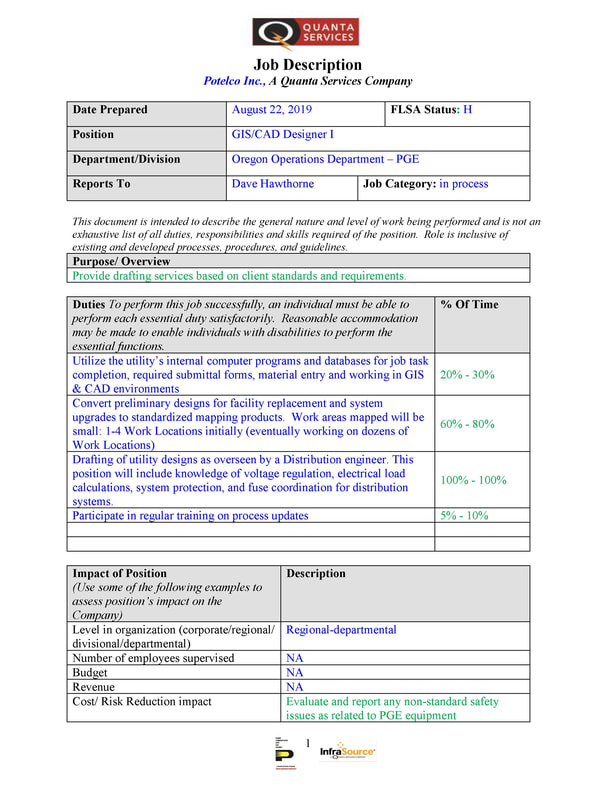
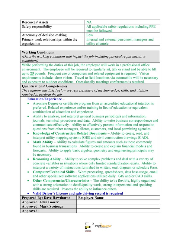
GIS/CAD Designer position available

0 Comments

Read Now
 
Picture
Picture
Contact 

Christian Schumann-Curtis
GIS Lead
Portland General Electric | Potelco Inc
7am-5.30pm, Monday thru Thursday
O: 503.718.6318
C: 503.774.3568
christian.schumann-curtis@pgn.com

Share

0 Comments

8/21/2019

GIS Tech w/ City of Tumwater (WA)

0 Comments

Read Now
 
The City of Tumwater has an exciting new opportunity that will expand your GIS skills in our dynamic and growing city.  The GIS Technician will perform a wide variety of tasks including creating beautiful maps, spending time in the great outdoors collecting City asset data, and interpreting engineering drawings to enhance the City GIS database.  If you are a fast learner, want to make a difference in your community, and have an interest in Public Works, this is the position for you!
 
This position is open until filled.  First review of applications will start September 9th.
 
https://www.governmentjobs.com/careers/tumwater/jobs/2537995/gis-technician
​

Share

0 Comments

8/21/2019

OSIP 2018 orthoimagery (western Oregon)

0 Comments

Read Now
 
The 2018 western Oregon 1ft orthoimagery is finally available! We'll be updating all the supporting Web pages as soon as we can but wanted to let everyone know that they can start streaming the data now.

You can access Web Services to stream the OSIP 2018 imagery from the REST endpoint URL here:
https://imagery.oregonexplorer.info/arcgis/rest/services

Instructions for consuming Web Services (REST & WMS) can be found here:
https://oregonexplorer.info/content/web-services-stream-imagery?topic=119&ptopic=98
(That page will be updated with direct links to the OSIP 2018 data soon.)

Direct download of the imagery is not available. Copies of the data are being provided on request through the Oregon Geospatial Enterprise Office by contacting David Mather, david.mather@oregon.gov.

Share

0 Comments

8/20/2019

GIS Analyst w/ City of Bellvue (WA)

0 Comments

Read Now
 
https://www.linkedin.com/jobs/view/1390580788/

What We're Looking For
​
Intermediate level position preparing GIS data support, including analysis support, data conversion/migration and map productions, with minimal supervision on projects.
  • Opportunity to join our growing Environmental Team of Planners and Permitting Experts.
  • Transportation and Transit Projects

Primary Focus Will Include
  • Interact directly with clients, both internal and external, and provide training and process knowledge to promote GIS.
  • Provides GIS technical support and promote GIS technology to design offices.
  • Provides market research and business development consulting as needed.
  • Develops and complete a GIS project lifecycle, requirements through implementation.
  • Develops or maintain GIS applications using a combination of GIS software, web-based development tools, and/or Windows development tools.
  • Develops applications using Arcview software to enhance existing and future GIS projects.
  • Performs other duties as assigned. 

Preferred Qualifications And Skills
  • 5 years related experience using ESRI, Intergraph, or Bentley software products.
What You'll Need

Essential Responsibilities
  • Interacts directly with clients, both internal and external, and provides training and process knowledge to promote GIS.
  • Provides GIS technical support and promotes GIS technology to design offices.
  • Provides market research and business development consulting as needed.
  • Develops and completes a GIS project lifecycle, requirements through implementation.
  • Develops or maintains GIS applications using a combination of GIS software, web-based development tools, and/or Windows development tools.
  • Develops applications using Arcview software to enhance existing and future GIS projects.
  • Performs other duties as assigned. 

Minimum Qualifications
  • Bachelor's degree in Computer Science, Engineering, Geography, Planning or other related field of study
  • 3 years related experience using ESRI, Intergraph, or Bentley software products

Share

0 Comments
<<Previous
Details

    Archives

    March 2023
    February 2023
    January 2023
    December 2022
    November 2022
    October 2022
    September 2022
    August 2022
    July 2022
    June 2022
    May 2022
    April 2022
    March 2022
    February 2022
    January 2022
    December 2021
    November 2021
    October 2021
    September 2021
    August 2021
    July 2021
    June 2021
    May 2021
    April 2021
    March 2021
    February 2021
    January 2021
    December 2020
    November 2020
    October 2020
    September 2020
    August 2020
    July 2020
    June 2020
    May 2020
    April 2020
    March 2020
    February 2020
    January 2020
    December 2019
    November 2019
    October 2019
    September 2019
    August 2019
    July 2019
    June 2019
    May 2019
    April 2019
    March 2019
    February 2019
    January 2019
    December 2018
    November 2018
    October 2018
    September 2018
    August 2018
    July 2018
    June 2018
    May 2018
    April 2018
    March 2018
    February 2018
    January 2018
    December 2017
    November 2017
    October 2017
    September 2017
    August 2017
    July 2017
    June 2017
    May 2017
    April 2017
    March 2017
    February 2017
    January 2017
    December 2016
    November 2016
    October 2016
    September 2016
    August 2016
    July 2016
    June 2016
    May 2016
    April 2016
    March 2016
    February 2016
    January 2016
    December 2015
    November 2015
    October 2015
    September 2015
    August 2015
    July 2015
    June 2015
    May 2015
    April 2015
    March 2015
    February 2015
    January 2015
    December 2014
    November 2014
    October 2014
    September 2014
    August 2014
    July 2014
    June 2014
    May 2014
    April 2014
    March 2014
    February 2014
    January 2014
    December 2013
    November 2013
    October 2013
    September 2013
    August 2013
    July 2013
    June 2013
    May 2013
    April 2013
    March 2013
    February 2013
    January 2013
    December 2012
    November 2012
    October 2012
    September 2012
    August 2012
    July 2012
    June 2012
    May 2012
    April 2012
    March 2012
    February 2012
    January 2012
    December 2011
    November 2011
    October 2011
    September 2011
    August 2011
    July 2011
    June 2011
    May 2011
    April 2011
    March 2011
    February 2011
    January 2011
    December 2010
    November 2010
    October 2010
    September 2010
    August 2010
    July 2010
    June 2010
    May 2010
    April 2010
    March 2010
    February 2010
    January 2010
    December 2009
    November 2009
    October 2009
    September 2009
    May 2009
    April 2009

    Categories

    All
    Aag
    Americorps
    Animations
    Applied GIS
    Applied Gis
    Apps
    Article
    Articles
    Asprs
    Books
    Careers
    Cartography
    Competition
    Conferences
    Conservation
    Diaster Mapping
    Drones
    Environmental
    Esri
    Events
    Fellowships
    Games
    Geoapp
    Geographic Awareness
    Geography
    Geomatics
    Geospatial Technologies
    GIS
    GIS Data
    Gis Data
    GIS Day
    GIS Day
    GIS Resources
    Gis-resources
    Google
    Google Earth
    Google Maps
    Gps
    Graduate School
    Grants
    Happy Hour
    Happy Hours
    Humor
    Hydrology
    International
    Internships
    Interviews
    Job
    Jobs
    Journals
    Lecture
    Lidar
    Maps
    Meeting
    National Geographic
    Natural Resources
    Open Source
    Oregon
    PCC
    Podcast
    Porland
    Portland
    Presentations
    Professional Development
    Professional-development
    Projections
    Raster
    Remote Sensing
    Research
    Scgis
    Scholarships
    Social Networks
    Software
    Songs
    STEM
    Story Maps
    Study Abroad
    Surveying
    Technical Help
    Tools
    Training
    UAS
    UAV
    University
    Urban Design
    Videos
    Visualization
    Webinar
    Web Mappping
    Websites
    Women In GIS
    Workshops

    RSS Feed

Contact ME

  • Home
  • About Me
  • Courses
  • GIS Club
    • About Us
    • Don't be a Dangle!
    • Event Calendar
  • Resources
    • Data
    • Tools
    • Blogs
    • ArcGIS Install
  • Blog
  • Aventuras Colombianas