|
https://www.governmentjobs.com/careers/seattle/jobs/2246223/gis-analyst-it-pro-c-bu
Position Description The Seattle Information Technology Department is seeking two GIS professionals to perform GIS analysis and cartographic work, maintain data on multiple thematic layers, support GIS end users, develop training materials and user guides, and deliver end user training. Temporary benefit eligible assignment is anticipated to last 6-9 months. Job Responsibilities
Qualifications Required Qualifications: Note: Combinations of education and/or experience which provide an equivalent background to perform the work of the class will be considered. Education: A two year or four year degree in Geography, Computer Science, Civil Engineering Technology, or related field Experience: High proficiency and at least two years of experience performing spatial analysis, data manipulation, data maintenance, and production of cartographic products, using ArcGIS. Experience with industry standard GIS/IT concepts, practices and techniques. Desired Qualifications
Additional Information NOTE:
http://www.masonbruce.com/careers/join-our-team/
About the Position Work on this project requires proficiency in GIS including but not limited to GIS analysis, ArcGIS Online, mobile data development and dashboard development. Work will be onsite at client offices and could be based in San Francisco, Sacramento or Auburn, California depending on the candidate’s preference. Work is a full-time salaried position The GIS Analyst will perform the following tasks: GIS Project Support
About You In order to excel at the Level 2 GIS Analyst position, you should possess the following skills, experience, and background:
About Us Mason, Bruce & Girard, Inc. is a full-service natural resource consulting firm, with expertise in environmental services, forestry and geographic information systems (GIS). A set of core values guide our work, focusing our efforts on providing responsible, sustainable solutions that meet client needs. Our areas of expertise include forestry, wildlife, fisheries, wetlands, water quality, and GIS. Our work is characterized by the highest level of client service, the application of the best science and technology, quality processes and results, integrity, and our respect for the natural environment. We provide natural resource consulting services to both industry and government, and have done so since 1921. Join Us/Apply Now Click here http://www.masonbruce.com/careers/join-our-team/ or visit the Careers section of our website to send us your resume. Mason, Bruce & Girard is an equal opportunity, affirmative action employer, and we do not discriminate against employees or job applicants on the basis of race, color, national origin, age, religion, gender, gender identity, disability, sexual orientation, veteran status, or any other status or consideration protected by local, state and federal laws, except where a bona fide occupational qualification applies. Equal opportunity applies to hiring, promotion, training, compensation, and any other organizational action. MB&G’s written Affirmative Action Plan is available to all employees and job applicants upon request. MB&G is proud to be an equal opportunity employer. https://www.powells.com/book/-9781426219726
Monday, November 5 @ 7:30 PM Powell's City of Books In All Over the Map (National Geographic), Greg Miller and Betsy Mason explore the intriguing stories behind maps from a variety of cultures, civilizations, and time periods. Their diverse compendium includes ancient maps of dragon-filled seas, elaborate graphics picturing unseen concepts and forces from inside Earth to outer space, devious maps created by spies, and maps from pop culture such as schematics to the Death Star and a map of Westeros from Game of Thrones. Calling all GISers!!!
Please pass on to those that might be interested… Wednesday, December 5th 2018 Brookwood Library - Event Room 2850 NE Brookwood Pkwy Hillsboro, OR 97124 The Brookwood Library Event room is located on the 2nd floor, Bring your own beverages (no host) Start 10 AM SHARP! End Noon-ish Agenda … Welcome and introductions Utilities in GIS! Northwest Natural Gas – 15 min Eric Stipe, GIS Supervisor Portland General Electric – 15 min Patrick Gronli, GIS manager Tualatin Valley Water District – 15 min Peter Boone, PE, PLS, Water Operations Division Manager PCC student presentation (Still pending) – 10 min Break/Networking – 10 -15 mins +/- (depending on time) ArcGIS Pro and the Utility Network – 20 min Esri, John Ruffing, Account Manager, Local Government (OR & ID) and or assignee Geocortex Essentials and Assets – 20 min Latitude Geographics, Matt Vaillant, Account Manager and or assignee Make plans after the session to go to lunch with some of your peeps or new ones! https://humantransit.org/2018/10/urgent-need-for-a-freelance-transit-cartographer-reply-by-nov-1-2018.html
Our firm is urgently looking for a detail-oriented cartographer who works freelance, and who has experience drawing transit maps in Adobe Illustrator. In the course of our planning studies, we create many transit maps for our clients, all in a similar style like the slice above. We need someone who can start at once and work quickly under direction. There is not much room for design creativity, as you will be revising maps whose style is already established. The job mainly rewards speed, accuracy, and an eye for clarity and completeness. I invite freelance cartographers to send us a quick note at [email protected] no later than Nov 1. Include:
We reserve the right to ask you to complete a very small task, taking no more than an hour, to establish your competence at the type of work we have. We are likely to have at least 60 hours of work for you as part of this contract. It’s possible that this could turn into something longer term. Our offices are in Portland, Oregon and Arlington, Virginia, but you don’t need to be there to meet with us directly, although it is helpful to be on the same side of the planet so that we can interact by phone easily. Reply by November 1 please, but because time is short we reserve the right to act as soon as we find the right person. Please spread the word if you know others who may be interested. Please save the date and mark your calendars for the 2018 celebration of GIS Day on Wednesday, November 14th from 11 AM to 2 PM at the Forest Service Pacific Northwest Regional Office in Portland, Oregon! The U.S. Forest Service Data Resources Management staff is hosting this public event, which will be held at the Edith Green-Wendell Wyatt Building (1220 SW 3rd Ave). The welcome-to-event booths and Smokey Bear photo opportunities will be held on the first floor gallery past the elevators. Guest speakers and interactive displays will occur on the ground floor in conference rooms 1b and 3. Speakers will be scheduled for short talks on the impact of GIS on different focus areas. Also on display will be examples of how the Forest Service and partners utilize geospatial information and Geographic Information Systems (GIS) technology for the Greatest Good. 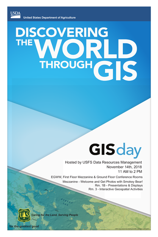 Hydrologic Technician III
The Klamath Tribes - Chiloquin, OR 97624 $34,137 - $49,615 a year CLOSES: 11/16/18 INTRODUCTION The Hydrologic Technician III position is located in the Aquatics Program within the Klamath Tribes Natural Resources Department. The primary purpose of this position is to support the Hydrologist by working independently and as part of a team performing field data collection tasks to develop scientific information regarding the movement and condition of water, especially as it relates to aquatic ecosystem functions, and then formulates and implements strategies for restoration, monitoring, or management. The Hydrologic Technician III will measure and monitor surface water and ground water flows, levels, and conditions, and integrates these data into scientific endeavors to restore and maintain aquatic ecosystems and regulatory processes designed to protect the Klamath Tribes’ water rights. Other duties include establishing and maintaining a network of gauges providing continuous measurements of water flow, level, and condition in rivers, streams, springs, lakes, marshes, and shallow ground water. The Hydrologic Technician III works with other Aquatics Program staff (Fish Biologist, Hydrologist, Fluvial Geomorphologist, Environmental Restoration Planner, and Water Quality Technicians) to implement a Fisheries Restoration Plan and an Aquatic Ecosystem Restoration Plan for the Upper Klamath River Basin. Restoring and maintaining important Tribal fisheries is the primary goal of the Fisheries Restoration Team. Primary objectives include: 1) re-establishing extinct spawning populations of endangered Lost River and Short Nose suckers; and 2) re-introducing extinct populations of Chinook salmon in the Upper Klamath River Basin. The primary goal of the Ecosystem Restoration team is managing and remediating processes contributing to hypereutrophication and fish habitat degradation in and above Upper Klamath Lake. Primary objectives include: 1) managing and remediating non-point source nutrient loading from agricultural landscapes to measurable reduce cyanobacteria blooms and the related adverse water quality in Upper Klamath Lake; and 2) rehabilitating and maintaining habitats to the extent necessary to recover and sustain important native fisheries, including Lost River and Short Nose sucker, Redband trout, Bull trout, Steelhead, and Chinook salmon. MAJOR DUTIES AND RESPONSIBILITIES
To apply: http://klamathtribes.org/administration/wp-content/uploads/2018/10/Hydrologic-Technician-III.pdf https://www.governmentjobs.com/careers/eugene/jobs/2235728/geographic-information-technician-2
Provides Geographical Information System (GIS) technical support and assistance to the Parks and Open Space Division with a primary focus on data development and maintenance, analysis and map production activities, including GIS and database quality assurance. Provides GIS assistance to staff and the public by producing maps and related data representation. Application Deadline: Wednesday, November 7, 2018, 5:00 p.m. Accepting on-line applications only. Examples of Duties Performed - Duties may include but are not limited to the following:
QualificationsKnowledge of:
Ability to:
Minimum Qualifications Any equivalent combination of education and experience which provides the applicant with the knowledge, skills and abilities required to perform the job. A typical way to obtain the knowledge and abilities would be: Experience Two years of technical experience in GIS systems. Training Equivalent to an Associate Degree in GIS, geography, cartography and/or computer programming. Come join us for our 7th annual GIS Day Celebration and a humanitarian mapathon! (Nov 14)10/23/2018
GIS Day Social What: Portland’s 7th Annual GIS Day Social When: Wednesday November 14th, 6:00pm - 9:00pm Where: Ecotrust, 721 NW 9th Ave #200, Portland, OR RSVP at: http://meetu.ps/e/FYTmh/jRd2q/f (you’re also welcome to just show up!) Please join us for Portland’s 7th Annual GIS Day Social! This year, we’ll gather in Ecotrust’s beautiful meeting space from 6pm - 9pm. The evening will feature:
Students, professionals, and anyone interested in GIS and geospatial technologies are all welcome. This is a great opportunity to make some new professional connections and strengthen old ones, and we hope to see you there! This event is volunteer run, and would be impossible without the generous support of our sponsors: Gold level: Quantum Spatial Silver level: ASPRS CRR, PCC, Ecotrust, OR-URISA, Mapbox Bronze level: PDX OSGeo, Esri, Metro, PSU, DOGAMI, SCGIS, PC Trask *Includes some gluten free, veggie, and vegan pizzas GIS Day Missing Maps Mapathon What: GIS Day Missing Maps Mapathon When: Wednesday November 14th, 3:30pm - 5:30pm Where: Portland State University, Geog Dept (exact room TBD) Register at: https://www.meetup.com/OpenStreetMap-Portland/events/254936446/ (We are limited to 30 people, so sign up soon) This year for GIS Day, use your geospatial skill to help people in vulnerable regions at this humanitarian mapathon! Madeline Steele of TriMet, a local OSM organizer, will lead the group, and we have booked a room at PSU with 20 computers and space for 10 laptops. It’s a great chance to do some good, learn about OSM, and meet a few like-minded mappers. If you can, please also join us for the GIS Day evening social at Ecotrust at 6pm. Details on that are here: Background on the Missing Maps project from the Red Cross Each year, disasters around the world kill nearly 100,000 and affect or displace 200 million people. Many of the places where these disasters occur are literally 'missing' from any map and first responders lack the information to make valuable decisions regarding relief efforts. Missing Maps is an open, collaborative project cofounded by the American Red Cross. It aims to put 200 million people "on the map" by 2021 - mapping areas where humanitarian organizations like the Red Cross are trying to meet the needs of vulnerable people. Due to current disasters and rapidly-changing needs, the November 15th Missing Maps tasks will be identified on or around November 1. http://www.missingmaps.org/ 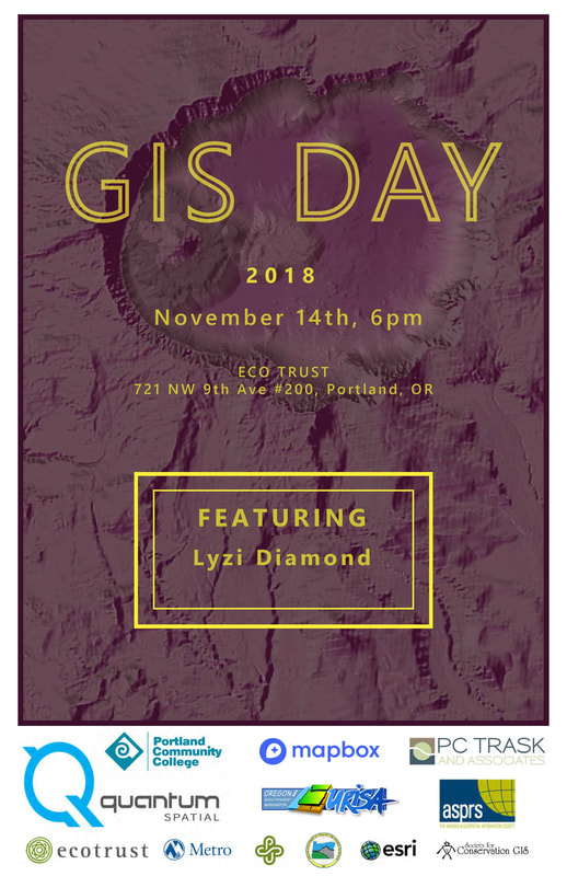 The Scholarship Committee at the American Society for Photogrammetry and Remote Sensing (The Imaging and Geospatial Information Society) wanted to remind you that the scholarship application window is open for the 2019 award year.
Awards will be presented at the ASPRS Annual Meeting, which will be held on January 28-31, 2019 in conjunction with the International LiDAR Mapping Forum (ILMF). Scholarships ranging from $2,000 to $7,000 are available to current students studying imaging, GIS, remote sensing, photogrammetry, surveying, and related digital spatial sciences. Applications are due by October 26, 2018, and letters of recommendation can be submitted by October 31, 2018. Please go to https://www.asprs.org/education/asprs-awards-and-scholarships to learn more about scholarships that are available. |
Categories
All
Archives
June 2024
|
 RSS Feed