 Cartography., esri's highly popular massive open online course (MOOC), is for anyone who wants to explore the art and science of mapmaking using ArcGIS Pro.
Over six weeks, learn essential cartography concepts from Esri experts and pick up tips and tricks to craft impactful maps that showcase your data. Join the course and try the latest ArcGIS Pro mapping and data visualization capabilities for yourself. Cartography. April 3–May 15, 2024 The Training Team Register Now → The course includes the following:
Posting Title:
National Geographic Cartographic Intern, Summer 2024Washington, DC, USA https://jobs.disneycareers.com/job/washington/national-geographic-cartographic-intern-summer-2024/391/60513723056 Full time Job Description: About the Role & Program Cartographers play a pivotal role within the storytelling framework at National Geographic! Maps serve as vital tools in conveying location and visualizing concepts and data that may be challenging to articulate through prose or photographs alone. This responsibility entails delving into a subject, identifying aspects that benefit from spatial representation, and engaging in an iterative process to ensure clarity for a general audience. These tasks span various media formats, including feature articles in National Geographic Magazine, digital releases, and interactive presentations. This internship focuses on honing journalistic skills to locate the most up-to-date spatial data, craft pertinent maps to enhance and bolster narratives, and collaborate with subject matter experts to meticulously verify all information. What You Will Do
Required Qualifications & Skills
Education To be eligible for this internship you must be a junior, senior or a recent graduate (within 6 months of your graduation date) pursuing a Bachelor’s Degree in Geography, History, Statistics or a related field. Eligibility Requirements & Program Information
GIS in Action Home Page
Below are some general details about the conference and a Map Gallery Contest. WHEN: The Conference will be held Tuesday, April 30 through Wednesday, May 1, 2024, with a pre/post-conference workshop on Monday, April 29, and Thursday, May 2. AT: The conference will be in downtown Portland at the Standard Insurance Building, home of Esri’s Portland R&D offices. The GIS in Action Conference has happened (almost) yearly for the last 32 years. There are many opportunities for students and instructors (like you) to interact with and share your work with other GIS professionals at the conference, including a Map Contest. MAP CONTEST: At the conference, I will be in charge of the Map Contest and would like to get as many contestants as possible. Could you tell your students about the conference and contest or possibly use a project in a class to be included in the contest? Here are the categories that a project can be placed in and some other details of the contest. CATEGORIES: • Analytic presentation - Communication of meaningful patterns in data • Cartographic - The quality of the visual display • Data Integration - Combining data from different sources • Web Applications – StoryMaps, ArcGIS Online, Tableau, Mapbox, Power BI, or Other • Student – Anyone enrolled in a class pursuing a degree or certificate In the student category, students will compete against other students. PRIZES: All conference attendees will be allowed to vote and will be given a ballot to vote for the best contest entries. Each category winner will receive a prize. In the past, prizes were $50 dollar gift certificates from REI. The second-place winners may also get a prize depending on how many people register for that category. HOW TO REGISTER: You can register for the Map Contest at this link: Register link here: Map Contest 2024 The format for contest entries can be hardcopy and/or digital maps, or web applications. Hard copy entries should be no larger than 3 ft by 5 ft to fit on the poster board.  USGS Water is hiring Data Visualization Specialists at multiple levels of experience to contribute to data visualization and science communication efforts at USGS. We seek creative individuals with experience taking complex, environmental datasets and developing static and interactive data visualizations using R, python, and/or javascript. For more information see this blog post: https://waterdata.usgs.gov/blog/viz-hires-2021/
These positions are with the water data visualization team, the USGS Vizlab. The USGS Vizlab is a collaborative science communication team that uses data visualization to communicate scientific data and concepts to non-technical audiences through compelling data-driven stories and graphics. See the Vizlab portfolio here Positions will be open to applications on USAjobs.gov from Wednesday November 17th at 12:00am EST to Tuesday November 23rd at 11:50 EST. These are full time, permanent federal positions in the Data Science Branch of the Water Mission Area at GS-09 and GS-12 grades. Location is negotiable. More information about the jobs and the application process can be found in our blog. We will also use the blog to post direct links to the job announcements when they are live on November 17th. Our Commitment to Diversity, Inclusion, and Transparency The federal hiring process can be complicated to navigate. We don’t want that to be the reason you don’t apply. We are committed to inclusive hiring practices that build a healthy workplace where diversity is our strength, and everyone has the support they need to succeed. We especially encourage you to apply if you are BIPOC, LGBTQIA+, have a disability, or are of any marginalized identity. Please read our blog post for details on how the application process works. Questions? Reach out to the hiring manager Jordan Read (he/him, at jread@usgs.gov), the Vizlab team lead Cee Nell (they/them, cnell@usgs.gov), or ask us on twitter @USGS_DataSci. In addition, we’ll be hosting two informational webinars about the positions and the application process:
NRCS is advertising a new Cartographer/GIS position located in the NRCS State Office in Portland, OR. This is a great opportunity for recent graduates and they encourage all to apply.
https://www.usajobs.gov/GetJob/ViewDetails/617935300 Summary The Pathways Recent Graduate Program is for recently graduated or graduating individuals who are looking for developmental experiences in the Federal Government intended to promote possible careers in the civil service. Recent Graduates will serve on this appointment for one year learning the fundamentals of the position for which they can be converted. For more information on the Pathways Recent Graduate Program, please visit https://www.usajobs.gov/StudentsAndGrads. Learn more about this agency Responsibilities
Please join us this Thursday OCT 21 for the third installment of our Fall 2021 speaker series! This week's Zoom talk is hosted by Hunter Shobe and David Banis from PSU's very own Geography Department. The topic is "Making a Cultural Atlas of San Francisco, Portland, and Seattle." Please see the attached pdf flier for more information and the clickable zoom link, as well as the attached schedule for coming speakers this term! 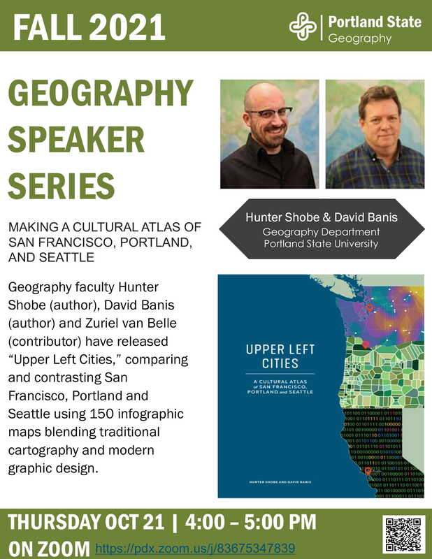 This is a great opportunity with the National Park Service. Please note they are only accepting the first 100 applications. See link for more details.
Cartographer DEPARTMENT OF THE INTERIOR National Park Service Recent Graduate Open & closing dates 12/03/2020 to 12/17/2020 This job will close when we have received 100 applications which may be sooner than the closing date. Pay scale & grade GS 9 https://www.usajobs.gov/GetJob/ViewDetails/586198600 The NACIS (North American Cartographic Information Society) annual conference is fast approaching, and with it our Student Mapping Competitions. Deadline for competitions is August 31, 2020. We ask that you forward this email on to any of your students whom you think may be interested in entering the competitions. Details and links below.
Our conference is virtual this year, and will be free for any NACIS members. Annual membership rates are $50USD for a general member, and only $20 for students. We highly encourage you and your students to register and participate in the conference! Conference Details: https://nacis.org/annual-meeting/current-meeting/ Student Map and Poster Competition: This competition is for students who have created static print maps or posters in the 2019-2020 academic year. In a typical year, the print maps are displayed in person at our conference Map Gallery. This year, with our virtual meeting, a digital version will appear in an online gallery. There are two, $500USD prizes to be won: for Cartographic Design and for Research. https://nacis.org/awards/student-map-and-poster-competition/ Student Dynamic Mapping Competition: This competition is open to students who have created any digital, screen-viewed dynamic, online, or interactive map in the 2019-2020 academic year. There are two, $500USD prizes to be won: Individual entries and Group Entries. https://nacis.org/awards/student-dynamic-map-competition/ If you or your students have any questions regarding the competitions, please contact Mary Beth Cunha or Martha Bostwick at posters@nacis.org for assistance. The Olmsted Center for Landscape Preservation is seeking excellent candidates to serve as Seasonal Cartographic Technicians. The announcement is posted on USAJOBS and closes April 6. Depending on the initial response, the deadline for applying may be extended so please spread the word! A direct link to the announcement is provided below.
GS-05 Seasonal Cartographic Technician https://www.usajobs.gov/GetJob/ViewDetails/563448300 GS-07 Seasonal Cartographic Technician https://www.usajobs.gov/GetJob/ViewDetails/563560900 This is a FREE event and everyone should go!
https://shoutout.wix.com/so/cfM_dOTos?cid=00000000-0000-0000-0000-000000000000#/main Portland State University’s Geospatial Information Society and PSU's Geography Department are hosting our 5th Cartography Symposium on Friday, March 6th at Portland State University - Smith Memorial Student Union Ballroom. This day long, free event has informative presentations on a variety of cartography topics, a web and print map gallery (now accepting submissions), and more! Visit the Cartography Symposium Website! |
Categories
All
Archives
March 2024
|
 RSS Feed