|
You and your students are invited to the 2024 NWGIS User Conference in Seaside, OR from September 23-26. New this year, we are having a juried poster session with two $100 Amazon gift card prizes for the overall conference favorite and NWGIS Board favorite. As part of the submission, your students will give a 5-10 minute presentation on their research during a technical track session on Wednesday instead of the typical poster session format. Winners will be announced Wednesday afternoon before the closing Keynote.
Students that submit a poster will receive a $50 discount code on their registration fee. A 1-day student registration fee is $100 and a 2-day fee is $200 before the discount. Please have your students submit their posters to me, and if accepted, they will receive a discount code for registration. We are also welcoming presentations from professors and students up to 20 minutes in length for our technical tracks. Presenters also receive a $50 discount on registration. The deadline for poster submission is Friday, Sept 13 by 5pm PST. Calling All Community College Student Innovators & Faculty/Administrator Mentors!
The deadline for the 2024 Community College Innovation Challenge (CCIC) is fast approaching! The CCIC is hosted by the American Association of Community Colleges in partnership with the National Science Foundation. It is a national competition where teams of community college students work with a faculty or administrator mentor to use science, technology, engineering, and mathematics (STEM) to innovate solutions to real-world problems, receive full travel support to attend an Innovation Boot Camp in Washington, D.C., and compete for cash awards. The Innovation Boot Camp provides professional development, mentoring, and coaching sessions to build strategic communication and entrepreneurial skills to help students advance their innovations in both the public and private sectors. The Boot Camp culminates in a poster session and engagement opportunity with STEM leaders and Congressional stakeholders, and a pitch presentation in front of a panel of industry professionals to determine the first, second, and third-place winning teams. Diverse and interdisciplinary teams that include students in STEM, business, humanities, and other fields are encouraged to apply. To hear from past participants and judges about the positive impact of participating, view our CCIC Information Sessions here. DEADLINE: Submissions are due by April 2, 2024. What can you do? JOIN: Assemble a student team and become a faculty or administrator mentor. SHARE: Help us spread the word and join the conversation online! #CCIChallenge2024. APPLY: Encourage students to learn more or apply at www.aaccinnovationchallenge.com. For questions, email [email protected]. The NACIS (North American Cartographic Information Society) annual conference is fast approaching, and with it our Student Mapping Competitions. Deadline for competitions is August 31, 2020. We ask that you forward this email on to any of your students whom you think may be interested in entering the competitions. Details and links below.
Our conference is virtual this year, and will be free for any NACIS members. Annual membership rates are $50USD for a general member, and only $20 for students. We highly encourage you and your students to register and participate in the conference! Conference Details: https://nacis.org/annual-meeting/current-meeting/ Student Map and Poster Competition: This competition is for students who have created static print maps or posters in the 2019-2020 academic year. In a typical year, the print maps are displayed in person at our conference Map Gallery. This year, with our virtual meeting, a digital version will appear in an online gallery. There are two, $500USD prizes to be won: for Cartographic Design and for Research. https://nacis.org/awards/student-map-and-poster-competition/ Student Dynamic Mapping Competition: This competition is open to students who have created any digital, screen-viewed dynamic, online, or interactive map in the 2019-2020 academic year. There are two, $500USD prizes to be won: Individual entries and Group Entries. https://nacis.org/awards/student-dynamic-map-competition/ If you or your students have any questions regarding the competitions, please contact Mary Beth Cunha or Martha Bostwick at [email protected] for assistance. AAG Innovative Applications of Esri GIS Technology Poster Competition
https://aag.secure-abstracts.com/AAG%20Annual%20Meeting%202019/sessions-gallery/23283 Call for Submissions Are you using Esri GIS technology to better understand an issue or problem from local to global scale and to propose solutions? If so, consider showcasing your work by participating in the Esri GIS technology poster competition at the 2019 American Association of Geographers (AAG) Annual Meeting in Washington, DC. In this session, you will learn from others as you discuss your poster with people from all over the world. Cash prizes in five categories will be awarded. Deadline for participation: February 14, 2019. http://www.geotechcenter.org/2019-geospatial-technology-skills-competition.html
The GeoTech Center is pleased to announce the 2019 Undergraduate Geospatial Technology Skills Competition! The intent of the competition is to showcase the geospatial technology skills of U.S. undergraduate students. Competing students will create a project that utilizes geospatial technology to address a real-world problem. The student will then present the project and the resulting deliverables as a Poster that not only highlights their use of geospatial technology, but also demonstrates their communication and presentation skills. The competition is software neutral. Applicants must meet all of the requirements below to qualify for the competition (questions regarding eligibility can be directed to either Tom Mueller ([email protected]):
The winners will be awarded registration, travel and accommodations to the 2019 GeoEd Conference in Louisville, Kentucky. The winners will also present their posters at this conference. Information on Registration coming soon…… Due March 8, 2019 at 1pm eastern. https://www.esri.com/en-us/industries/government/departments/isi-student-contest/overview
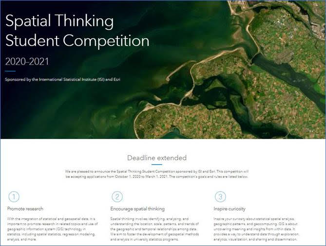
Call for Competition We are pleased to announce the ISI (International Statistics Institute) Esri Student Poster Competition 2018/19. Final judging will take place during the ISI World Statistics Congress in Kuala Lumpur, Malaysia, August 18–23, 2019. This competition is sponsored by Esri and ISI. The competition aims to: Promote research - With the integration of statistical and geospatial data, it is important to promote research in topics related to this integration and use of GIS in statistics, including spatial statistics, regression modeling, spatial data management, mapping, visualization and analysis. Encourage spatial thinking - Spatial thinking involves identifying, analyzing, and understanding the location, scale, patterns, and trends of the geographic and temporal relationships among data. We aim to foster the development of geospatial methods and analysis in university statistics programs. Inspire curiosity - Inspire your curiosity about statistical spatial analysis, geographic patterns, and geocomputing. GIS is about uncovering meaning and insights from within data. It provides a way to understand through data exploration, analytics, visualization, and sharing and dissemination. http://www.geotechcenter.org/2019-geospatial-technology-skills-competition.html
The GeoTech Center is pleased to announce the 2019 Undergraduate Geospatial Technology Skills Competition! The intent of the competition is to showcase the geospatial technology skills of U.S. undergraduate students. Competing students will create a project that utilizes geospatial technology to address a real-world problem. The student will then present the project and the resulting deliverables as a Poster that not only highlights their use of geospatial technology, but also demonstrates their communication and presentation skills. The competition is software neutral. Applicants must meet all of the requirements below to qualify for the competition (questions regarding eligibility can be directed to either Tom Mueller ([email protected]):
The winners will be awarded registration, travel and accommodations to the 2019 GeoEd Conference in Louisville, Kentucky. The winners will also present their posters at this conference. Information on Registration coming soon…… Due February 15, 2019 at 1pm eastern. Submission instructions will be sent out next month. Check out the website: http://www.geotechcenter.org/2018-geospatial-technology-skills-competition.html
The GeoTech Center is pleased to announce the 2018 Undergraduate Geospatial Technology Skills Competition! The intent of the competition is to showcase the geospatial technology skills of U.S. undergraduate students. Competing students will create a project that utilizes geospatial technology to address a real-world problem. The student will then present the project and the resulting deliverables as a Poster that not only highlights their use of geospatial technology, but also demonstrates their communication and presentation skills. The competition is software neutral. There will also be a prize for the best Open Source GIS project given by the Open Source Geospatial Foundation Applicants must meet all of the requirements below to qualify for the competition (questions regarding eligibility can be directed to either Tom Mueller ([email protected]):
The winners will be awarded registration, travel and accommodations to the 2018 GeoEd Conference in Louisville, Kentucky. The winners will also present their posters at this conference. Due April 20th at 1pm eastern. More information in early 2018. Check out our website: http://www.geotechcenter.org/2018-geospatial-skills-competition1.html
The GeoTech Center is pleased to announce the 2018 Undergraduate Geospatial Technology Skills Competition! The intent of the competition is toshowcase the geospatial technology skills of U.S. undergraduate students. Competing students will create a project that utilizes geospatial technology to address a real-world problem. The student will then present the project and the resulting deliverables as a Poster that not only highlights their use of geospatial technology, but also demonstrates their communication and presentation skills. The competition is software neutral. Applicants must meet all of the requirements below to qualify for the competition (questions regarding eligibility can be directed to either Tom Mueller ([email protected]):
The winners will be awarded registration, travel and accommodations to the 2018 GeoEd Conference in Louisville, Kentucky. The winners will also present their posters at this conference. Due April 20th at 1pm eastern. |
Categories
All
Archives
June 2024
|
 RSS Feed