CHRISTINA FRIEDLE

Geospatial Jobs, Internships, events, news & More

  • Home
  • About Me
  • Courses
  • GIS Club
    • About Us
    • Don't be a Dangle!
    • Event Calendar
  • Resources
    • Data
    • Tools
    • Blogs
    • ArcGIS Install
  • Blog
  • Aventuras Colombianas

3/30/2021

Wetland Mapping/GIS Specialist w/ SWCA (pdx)

0 Comments

Read Now
 
https://careers-swca.icims.com/jobs/11297/job?mobile=false&width=1903&height=500&bga=true&needsRedirect=false&jan1offset=-480&jun1offset=-420

​About the opportunity
SWCA Environmental Consultants is seeking a Wetland Mapping - GIS/Remote Sensing Specialist for our Portland, Oregon office. 

We are expanding our wetland mapping team and seeking on-call hourly specialists to support projects in the Pacific NW. Work hours may vary and depending on project needs and your skills. As our wetland mapping team continues to grow, additional opportunities for advancement and/or transition to a regular, full-time position could become available. In addition, this position may include collaboration and support for natural resources program.

This position is temporary, hourly. Pay is dependent on experience.
What you will accomplish 
  • Use remote sensing, GIS and photo interpretation techniques to identify and classify wetlands and other habitats within the US.
  • Work independently on repetitive tasks for extend periods, followed by periods of intensive group interactions during data integration and review using novel and unique GIS approaches.
  • Use numerous GIS and imagery datasets to inform photo interpretation and mapping processes, with a focus on identifying errors of omission, commission and classification.
  • Plan, organize, and execute field verification of wetland and other habitat mapping efforts.
  • Uses GPS, GIS, databases, and remote sensing software for mapping and analysis activities.
  • Ability to create intricate workflows and models to more efficiently map natural resources.

Experience and qualifications for success
Required Qualifications:
  • Experience with ESRI’s ArcGIS software suite.
  • Knowledge of GPS, GIS, cartography, spatial analysis methods and other current technologies.
  • Ability to think critically and effectively communicate.
  • Ability to work efficiently and collaborate with existing mapping team.
  • Knowledge of ecology, wetlands, and hydrology pertaining to wetland mapping and/or natural resources.

Preferred Qualifications:
  • Bachelor’s degree in Biology, Geography, Geology, Environmental Science or a related field.
  • Prior experience with National Wetland Inventory (NWI) mapping and NWI data creation standards.
  • Knowledge of the USFWS’s wetlands classification system (Cowardin et al. 1979) and familiarity with other classification systems (NVCS, NLCD, etc.) and their field application.
  • Knowledge of the principles of fish and wildlife biology, botany, hydrology, and soils for preparation of user notes/base map reports, for completion of field surveys, and for technical assistance.
  • Plant identification experience, especially wetland species

SWCA Environmental Consultants is a growing employee-owned firm, providing a full-spectrum of environmental services. With offices across the United States, SWCA is one of the largest environmental compliance firms and ranks among Engineering News-Record’s Top 200 Environmental Firms.

If you would like to contact SWCA regarding the accessibility of our website or need assistance completing the online application process due to a disability, please email accommodations@swca.com or call 800-828-8517. This contact information is for disability accommodation requests only. All other inquiries will not receive a response. 
 
EOE - women, minorities, individuals with disabilities and veterans are encouraged to apply.

Share

0 Comments

3/30/2021

GIS Technician - Mapping Dept w/ City of Caldwell (Caldwell, ID)

0 Comments

Read Now
 
https://www.cityofcaldwell.org/Home/Components/JobPosts/Job/464/479?ittk=EXee-H--eZR63cQISS09rDVW7hpL10f-2_O7Bv4Homs

​Job Summary/Qualifications: The City of Caldwell has an opening for a GIS Technician to provide support to the Caldwell City Mapping Department. Individual performs field data collection of City infrastructure and assists in the creation, development and maintenance of complex Geographic Information System (GIS) products and databases; provides technical assistance and support to users regarding GIS technology solutions and map generation for the City’s infrastructure, services and geographic features; performs activities related to field location of City utilities such as water, sewer, storm drain, pressure irrigation, street light, and fiber optic conduits; enters field data into GIS database; performs other duties as assigned or needed. Possession of a current and valid Idaho State driver’s license. Subject to pre-employment drug screening and background check.

Education:
 Graduation from an accredited college or university with an Associate’s Degree in Mapping, Geography, or other GIS related fields with a minimum of one year coursework related to GIS; or minimum of two years’ experience in GIS related activities; and working knowledge of the use of computer software and hardware related to GIS development and support; or any equivalent combination of experience, education and training which provides the knowledge, skills and abilities necessary to perform the work. Previous experience with ESRI ArcGIS, surveying and mapping is preferred.

Benefits:
 Exceptional Benefits

Share

0 Comments

3/30/2021

GIS Intern w/ Lewis County PUD (Chehalis, WA)

0 Comments

Read Now
 
https://www.governmentjobs.com/careers/lcpud/jobs/2994921/gis-intern

​About the Position

The GIS Intern will provide temporary assistance to the Engineering Department with a variety of projects and tasks; including but not limited to field work, preparing and updating maps, accurately recording and documenting activities.

Essential Duties and Responsibilities

Including the following. Other duties, responsibilities, and activities may change or be assigned at any time with or without notice.
  • Support the District’s goal of making our customers our #1 advocates.
  • Assist Engineering Department in a variety of tasks associated with the District’s work.
  • Assist with data integrity and data maintenance as it relates to the District’s strategic initiatives.
    Create and maintain accurate GIS records and documents.
  • Edit existing shapefiles, geodatabases, and relational databases.
  • Compile, manipulate and analyze data sets such as GIS locations of electrical facilities, outage events, work and asset management systems to support Engineering Department decisions and recommendations.
  • Field verify, acquire, download, correct, and document utility system information to prepare maps, drawings, etc. as directed.

Position Requirements

To perform this job successfully, an individual must be able to perform each essential duty satisfactorily. The requirements listed below are representative of the knowledge, skill, and/or ability required. Reasonable accommodations may be made to enable individuals with disabilities to perform the essential functions.

Supervisory Responsibilities:
This position has no supervisory responsibilities.

Education and/or Experience:

Must be enrolled in an accredited college program leading to an Associates or Bachelor’s of Science degree in engineering, computer science or Geographic Information Systems. ArcGIS, AutoCAD and system modeling tool or similar experience and/or coursework preferred.

Certificates, Licenses, or Registrations:
Must have a valid Driver’s license.

Computer Skills:
To perform this job successfully, an individual must be proficient in MS Outlook, Excel, and Word. Experience in Geographic Information Systems software preferred.
  • Ability to type at least 45 words per minute.
  • Excellent verbal and written communication skills.
  • Excellent interpersonal and customer service skills.
  • Excellent organizational skills and attention to detail.
  • Excellent time management skills with a proven ability to meet deadlines.

Physical Demands:

The physical demands described here are representative of those that must be met by an employee to successfully perform the essential functions of this job.

While performing the duties of this Job, the employee is frequently required to walk, climb stairs, bend, reach, uses hands to finger, handle, or feel, and sit for extended periods of time. Occasionally required to lift and carry up to 40 pounds. Required to speak and hear clearly when communicating over the telephone and in person.

Work Environment:
The work environment characteristics described here are representative of those an employee encounters while performing the essential functions of this job. Many of the job duties will be in an office environment. Must dress and present yourself in a way that promotes a positive image of the District and meets the District’s dress code policy. Prolonged computer related exposure. Able to sit/stand at a workstation and operate a keyboard for long periods of time. Must be able to work for extended periods of time in a seated or standing position. While performing the duties of this job, the employee may be exposed to outdoor environments. Outdoor settings include all types of property and site conditions including open spaces, timberlands, urban developments, flat and hilly terrain, building construction sites, and road rights-of-way.


Share

0 Comments

3/30/2021

Conservation Specialist w/ Clackamas Soil & Water  Conservation District (OR)

0 Comments

Read Now
 
https://conservationdistrict.org/2021/conservation-specialist-position-announcement.html

Clackamas Soil and Water Conservation District seeks an experienced Conservation Specialist. This individual will work mainly with small farms and rural/urban residential properties. The ideal candidate will have a working knowledge of plant material including proper placement and maintenance. A demonstrated working knowledge of urban conservation practices including bioswales and rain gardens is also desirable.

Conservation Specialist
The Conservation Specialist provides technical help to landowners, collaborating to successfully implement practices that conserve natural resources. We are looking for a self-starter who can work independently and as an integral member of the District’s conservation planning team. They must have the ability to communicate clearly and effectively. The Conservation Specialist is expected to provide superior customer service and to behave in a professional manner.

If you have a bachelor’s degree in an agricultural or natural resources-based field of study and one year of directly related conservation planning experience; OR five years of directly related conservation planning experience or any equivalent combination of experience, training and/or education, please consider applying for this position. Details, including additional qualifications, compensation, and benefits can be found in the complete job description posted below.

​Apply Today! Application Deadline is April 16, 2021
A full position description and an application form are available below. To apply, please send a completed application, resume, and cover letter to 22055 S. Beavercreek Road Suite 1, Beavercreek, OR 97004. You may also submit it electronically to District General Manager Christopher Lapp at clapp@conservationdistrict.org.

​All application materials must be received electronically by midnight on April 16, 2021 OR postmarked by April 16, 2021 if submitting via ground mail.

Share

0 Comments

3/29/2021

PSU Geology/SOE/USGS/OSU Water Resources Seminar Series

0 Comments

Read Now
 
Please see attached the attached flyer for our spring term PSU/SOE/USGS/OSU Water Resources Seminar Series. The Seminars are on Wednesdays at 4pm except for one that will be on May 19 at 12pm. This one will also have a separate zoom invitation.

Please visit our website for more information on each event.

Zoom meeting ID: 929 4486 8945
Password: SeminarWRS
Picture

Share

0 Comments

3/29/2021

Enterprise GIS Administrator w/ City of Bend (OR)

0 Comments

Read Now
 
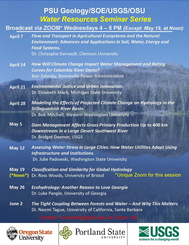
The City of Bend is looking for an Enterprise GIS Administrator (Senior Information Systems Analyst) to join our team!   Applications received by Friday, April 9, 2021 at noon will receive preference for initial review.

The Enterprise GIS Administrator provides advanced journey technical services using the Esri platform. This position is responsible for the design, implementation, and maintenance of complex or enterprise-scale geodatabases, enterprise data models, automation scripts, and applications.  In this role, you won’t just be working behind the scenes, but collaborating with business units and technical team members to understand their needs.  You’ll recommend how to achieve desired results, whether through complex analysis, data integration, application development, or data visualization techniques, then execute projects from concept to completion.  

​For more information on the position and how to apply:
https://www.governmentjobs.com/careers/bend/jobs/3025138/sr-information-systems-analyst

Share

0 Comments

3/27/2021

Senior Environmental Specialist, Land & Water (Exempt) w/ Port of Portland

0 Comments

Read Now
 
https://www.governmentjobs.com/jobs/3018988-0/senior-environmental-specialist-land-water-exempt/agency/portofportland

General Information
As a Senior Environmental Specialist, you will provide professional and technical support for the Port's Water and Land Programs in order to fulfill the organizations environmental commitments, facilitate business development, and ensure compliance with applicable environmental laws and regulations as well as Port policies and procedures.   Function as lead for aspects of program planning and delivery including budgeting and consultant and contractor oversight. If you thrive in an environment of collaboration and share our passion for water and land quality, water conservation and environmental stewardship then this might be the opportunity you've been waiting for. 

Summary of Essential Responsibilities

  • Regulatory Compliance:
    • Provide professional and technical support for the development of strategies to help meet regulatory success criteria. 
    • Help track regulatory issues and trends to maintain the highest and best knowledge of technical and regulatory information. 
    • Effectively communicate environmental regulations, permit conditions, and policies within the Port and with relevant external stakeholders. 
    • Collect and interpret data and prepare reports to demonstrate compliance with regulatory obligations including, but not limited to:
      • Federal: National Pollution Discharge Elimination System Municipal Separate Storm Sewer System permits; Underground Storage Tank management and Spill Response. 
      • State: Industrial Stormwater permits (1200-C, 1200-CA, 1200-Z), Underground Storage Tank Program. 
      • Local: Various permits issued by METRO, Multnomah County, Washington County, City of Portland, City of Hillsboro and City of Troutdale
  • Program Delivery: 
    • Support successful delivery of the Water and Land programs. 
    • Conduct research and interpret information to support development and implementation of applicable Port policies, standards, processes and resource management plans. 
    • Support cross-departmental planning and communications as well as development of recommendations on complex Port business issues. 
    • Support implementation of the Environmental Management System including regular reporting on program performance. 
    • May oversee outside services contracts and budgets.
  • Project and business opportunity analysis:
    • Provide professional and technical support across all Port operating areas regarding stormwater, water quality, water conservation, spill prevention, control and countermeasures, and soil, sediment and surface water sampling/monitoring procedures and methods. 
    • Conduct opportunity evaluations of: Port master, facility and other plans; capital projects; business transactions, proposals and designs; and operations and maintenance activities. Identify cost-saving opportunities.
  • Other Projects:
    • Manage the environmental aspects of multi-disciplinary projects as appropriate.

Minimum Requirements

  • Bachelor’s degree in environmental management/science or an equivalent combination of education and relevant experience is required. Master’s degree is preferred. 
  • Minimum of five (5) years of relevant work experience is required.
  • Demonstrated knowledge of federal, state and local laws, regulations, permits and plans associated with management of stormwater, spill prevention control and countermeasures is required.
  • Demonstrated knowledge of soil, sediment, surface water and groundwater analysis and analytical methods is required.
  • Prior experience overseeing and directing the work of consultants and contractor is preferred.
  • Experience with program budget development and management is preferred.
  • Intermediate proficiency with current Microsoft Office Suite software is required.  Advanced proficiency is preferred.
  • Valid driver's license is required.
  • Ability to obtain technical certification in Hazardous Waste Operations and Emergency Response Standard to support spill response, ideally within three months from date of hire.
  • Ability of obtain and maintain security clearance to gain access to Port’s airports, marine terminals and other properties is required.

Skills and Abilities

  • A “can do” attitude; swiftly identifies issues and seeks creative solutions. 
  • Respectful and proficient written and verbal communications skills and able to tailor content to varying audiences. 
  • Skilled at managing project ambiguity, complexity, and interdependencies in a methodical and structured way. 
  • Willingness to promote safety as a guiding principle and a regular practice in accomplishing work; focuses on safety improvements and complies with safety and health policies and procedures. 
  • A proven team player who shows the utmost respect for others.
  • Ability to:  
    • Apply a broad range of knowledge to the completion of complex and challenging assignments.
    • Build relationships and work cooperatively with diverse stakeholders and solve complex problems.
    • Plan, organize, and schedule all phases of work products to achieve quality outputs on schedule. 
    • Work effectively in collaboration with junior staff, peers, and management. 
    • Resolve problems with minimal conflict, and motivate colleagues to collaborate. 
    • Multi-task in a high energy environment; proactively work through ambiguity. 
    • Work without supervision; apply good judgment on when to escalate matters. 
    • Orient, train and oversee performance of junior peers on support tasks. 
    • Create a positive work environment and demonstrate commitment to valuing differences among individuals and passion for being inclusive.

Share

0 Comments

3/23/2021

Cultural Resources GIS Internship w/ National Park Service (remote)

0 Comments

Read Now
 
National Park Service
Cultural Resources GIS Internship
San Francisco Regional Office


Position Description
Works remotely and assists National Park Service (NPS) Cultural Resources Program staff with creating and editing spatial data for historic structures and cultural landscapes located in various National Park sites within the western United States. Duties include editing Geographic Information System (GIS) spatial data and attribute tables using the NPS Cultural Resources Spatial Data Transfer Standards. Knowledge and experience using ArcGIS and editing attribute tables required. Familiarity with cultural resources preferred, but not
required.

The position is through Conservation Legacy (http://www.conservationlegacy.org).

Location
Remote. Position will work with the staff at the NPS Regional Office at 333 Bush Street, San Francisco.

Compensation
$23.75 per hour

Length of Position
12 weeks, fulltime.

Start Date
Negotiable between May and July.

Requirements
• Must be a US citizen.
• This is a youth stewardship position to be filled by a person ages 15-35, but does
not need to be a current student.
• Must pass federal background check.
• Experience with the current suite of ESRI ArcGIS software and extensions.
• Possess practical knowledge of geodatabase design principles and understanding
of geographic projection datums and geospatial data.
• Proficiency in geospatial data management, including working with
geodatabases, performing database queries, georeferencing, and data creation.
• Attention to detail and strong organizational skills.
• Understanding of data quality control concepts.

Send cover letter and resume to Vida Germano at vida_germano@nps.gov by April 9, 2021.

Share

0 Comments

3/23/2021

GIS Technician (part-time) w/City of Cupertino (CA)

0 Comments

Read Now
 
https://www.governmentjobs.com/careers/Cupertino/jobs/3009534/gis-technician-part-time 

​The City of Cupertino's Innovation Technology Department has a part-time unbenefited job opportunity for a Geographic Information Systems (GIS) Technician. This position is part-time, non-benefited, and limited to 995 hours per fiscal year.

​Under general supervision, this position performs technical work in support of the City’s GIS administration, including meeting with department personnel to discuss GIS product requests, such as maps and reports, analyzing requests, generating requested products, and maintaining data and GIS databases; and performs related work as required.

Class Characteristics
This is a single-position classification responsible for supporting the City’s GIS function and related equipment. Incumbents are expected to possess the ability to perform the full range of technical duties related to GIS, in addition to performing a variety of record keeping, research, and technical support activities. The work requires the frequent use of tact and judgment, knowledge of City-wide operations, and the ability to conduct independent projects. This class is distinguished from GIS Program Manager in that the latter has overall management responsibility for all planning projects and programs, functions, and activities of the GIS program and for developing, implementing, and interpreting divisional goals for this function.

Supervision Received and Exercised

Receives general supervision form the GIS Program Manager. Exercises no direct supervision over staff.
Essential Duties
  • Management reserves the right to add, modify, change, or rescind the work assignments of different positions and to make reasonable accommodations so that qualified employees can perform the essential functions of the job.
  • Provides GIS support for City departments and programs including the development of maps (static and interactive), dashboards, tables, displays, presentations, graphics, brochures, and drawings.
  • Compiles and enters data into GIS databases, including scanning, data conversion, and digitizing maps.
  • Performs City research activities to identify, acquire, and integrate data from other agencies and organizations into the City’s data library; maintains and updates the City’s information catalogue.
  • Analyze GIS data to identify spatial relationships and/or display results of analyses, using maps, graphs, or tabular data.
  • Develops documentation and quality control procedures, standards, and metadata; reviews new and existing data for accuracy, quality, and completeness and updates where appropriate.
  • Acts as point of contact for the day-to-day operations of the GIS program; Explains technical information to non-technical end users, including assisting them in accessing and interpreting GIS information; trains end users on the use and functionality of the GIS system.
  • Performs field data collection or app testing.
  • Prepares a variety of written correspondence, reports, procedures, and other materials.
  • Maintains accurate records and files related to the GIS function.
  • Attends and participates in professional group meetings; stays abreast of new trends and innovations in the field of GIS administration.
  • Performs related duties as assigned.
Qualifications
Knowledge of:
  • Technology, hardware and software, and current applications related to GIS ESRI systems, including, but not limited to AGOL, web templates, Pro, editing, mapping and report generation, and desktop publishing systems.
  • Applicable Federal, State, and local laws, codes, and requirements and related reports.
  • Researching and reporting methods, techniques, and procedures.
  • Methods and techniques of effective technical report preparation and presentation.
  • Task management practices and procedures.
  • Modern office practices, methods, and computer equipment and applications related to the work, including the O365 & ArcGIS software.
  • English usage, grammar, spelling, vocabulary, and punctuation.
  • Techniques for providing a high level of customer service by effectively dealing with the public, vendors, contractors, and City staff.
Ability to:
  • Prepare a variety of plans, specifications, maps, graphic materials, and technical reports.
    Modify maps (static and initiative), plans, layers, templates, and illustrative graphics using GIS software and other software as appropriate.
  • Conduct routine research projects, evaluate alternatives, and make sound recommendations.
  • Interpret, apply and explain technical materials to non-technical users.
  • Make sound decisions within established policy and procedural guidelines.
  • Organize own work, adopt work management system for tracking assignment status, set priorities, and meet critical time deadlines.
  • Operate modern office equipment including computer equipment and specialized software applications programs.
  • Use English effectively to communicate in person, over the telephone, and in writing.
  • Use tact, initiative, prudence, and independent judgment within general policy, procedural, and legal guidelines.
  • Establish, maintain, and foster positive and effective working relationships with those contacted in the course of work.
Education and Experience
  • Any combination of experience and training that would provide the required knowledge and abilities is qualifying. A typical way to obtain the required qualifications would be:
  • Equivalent to an Associate’s degree from an accredited college or university with major coursework in cartography, geographic information science, geography, information systems, computer science, or related field and two (2) years of experience creating maps and performing spatial analysis using GIS software and/or database management technical support.
Licenses and Certifications
  • Possession of, or ability to obtain an appropriate, valid California driver license.

Physical Demands

Must possess mobility to work in a standard office setting and use standard office equipment, including a computer; to operate a motor vehicle and to visit various City sites; vision to read printed materials and a computer screen; and hearing and speech to communicate in person and over the telephone. Standing in and walking between work areas is frequently required. Field work is requested from time to time, so the ability to drive to site location and walk a mile at a time is required. Finger dexterity is needed to access, enter, and retrieve data using a computer keyboard or calculator and to operate standard office equipment. Positions in this classification frequently bend, stoop, kneel, and reach to perform assigned duties, as well as push and pull drawers open and closed to retrieve and file information. Employees must possess the ability to lift, carry, push, and pull materials and objects up to 25 pounds with the use of proper equipment.

Environmental Elements
Employees work in an office environment with moderate levels, controlled temperature conditions, and no direct exposure to hazardous physical substances.

Share

0 Comments

3/23/2021

CAD/GIS Technician w/ Idaho Power (Boise, ID)

0 Comments

Read Now
 
https://idahopowercompany.wd1.myworkdayjobs.com/en-US/External/job/Boise-ID/CAD-GIS-Technician-II_R0001786

Idaho Power — located in vibrant Boise, Idaho — is looking for a CAD/GIS Technician II to join our team. It’s an exciting time to work for Idaho Power. We’re working toward our goal of providing 100% clean energy by 2045, and our work plays a critical role in our customers’ lives and in communities we serve across Idaho and Oregon.

​What does a CAD/GIS Technician II do for us? Under limited supervision, uses the company's GIS products (ArcMap, ArcFM, and ArcSDE) to edit database per information from field personnel and primarily uses Autodesk products (AutoCAD Civil 3D) to create new drawings and modify existing drawings to reflect "as-built conditions". Updates and revises all associated and pertinent drawings, maps and documents.
  • Locates and lays out property, easements, rights-of-way, and permits from legal descriptions and creates Plan and Profile layouts from survey and profile data. Extracts map data from Arc. Preforms land records research of plats, records of survey, right of way drawings, and other land boundary and easement records. Utilizes enterprise GIS, LiDAR data, Orthoimagery, and survey data to compile drawings for analysis. Converts engineering drawings with an understanding of different coordinate systems and ground scale factors.
  • Produces specialized maps for internal customers as requested.
  • Maintains quality control for a clean, fully functional, accurate database that is utilized company-wide. Archives land survey project data to the enterprise GIS system.
  • Uses the company's GIS system to realign current electric facilities to points collected in the field; updates database attributes to reflect field observations.
In addition to the meaningful work we do, we offer work-life balance, competitive pay and benefits, and both a 401k employer-match and a pension plan, making Idaho Power one of the best employers in the state.

REQUIRED SKILLS

Knowledge of:
  • Current versions of ArcGIS software
  • AutoCAD Civil 3D, and Windows
  • Basic electricity concepts
  • Civil and Survey mapping concepts
  • File management
Preferred:
  • Civil or Survey drafting
  • Python or SQL scripting
  • Shapefile Queries
Skills in:
Good interpersonal communication skills, problem solving, customer service
Highly accurate and detail-oriented, meet accepted deadlines
Ability to:
Accept responsibility, adapt readily to new situations, work in a team environment, provide quality drafting support

MINIMUM REQUIREMENTS

Education:
High school diploma or GED
AND
Completion of a formal drafting technology program or AutoCAD certification
OR
Associate's degree in Geographic Information Systems (GIS) or Drafting Technology
OR
An equivalent combination of relevant education, experience and/or certifications
Preferred:
Associates degree in Geographic Information Systems (GIS) OR Associates degree in Drafting Technology
Experience:
Three or more years of experience with GIS technology or current version of AutoCAD, including a minimum of one of year experience with each
OR equivalent combination of relevant education and experience
Preferred:
Seven years of experience using ArcGIS, Autocad, Civil 3D, (civil, structural and mechanical)
Demonstrated experience with survey point data and legal description knowledge

PHYSICAL REQUIREMENTS

This position requires working at a desk/computer for extended periods of time. It requires the use of office equipment, fine motor skills including typing on the computer, dialing phones, filing paper, and working in close proximity to other people. There may be occasional lifts of no more than 10 lbs. The above is a summary of the primary essential functions of the position. This job may require the performance of additional tasks assigned by company leaders or management. Questions regarding job requirements or accommodation requests should be directed to Human Resources.

ADDITIONAL INFORMATION

Works with limited supervision. Accepts other duties as assigned.

Competencies:

Adaptability, Applied Learning, Building Customer Loyalty, Building Strategic Work Relationships, Communication, Contributing to Team Success, Decision Making, Managing Work (includes Time Management), Quality Orientation, Stress Tolerance

Share

0 Comments
<<Previous
Details

    Archives

    March 2023
    February 2023
    January 2023
    December 2022
    November 2022
    October 2022
    September 2022
    August 2022
    July 2022
    June 2022
    May 2022
    April 2022
    March 2022
    February 2022
    January 2022
    December 2021
    November 2021
    October 2021
    September 2021
    August 2021
    July 2021
    June 2021
    May 2021
    April 2021
    March 2021
    February 2021
    January 2021
    December 2020
    November 2020
    October 2020
    September 2020
    August 2020
    July 2020
    June 2020
    May 2020
    April 2020
    March 2020
    February 2020
    January 2020
    December 2019
    November 2019
    October 2019
    September 2019
    August 2019
    July 2019
    June 2019
    May 2019
    April 2019
    March 2019
    February 2019
    January 2019
    December 2018
    November 2018
    October 2018
    September 2018
    August 2018
    July 2018
    June 2018
    May 2018
    April 2018
    March 2018
    February 2018
    January 2018
    December 2017
    November 2017
    October 2017
    September 2017
    August 2017
    July 2017
    June 2017
    May 2017
    April 2017
    March 2017
    February 2017
    January 2017
    December 2016
    November 2016
    October 2016
    September 2016
    August 2016
    July 2016
    June 2016
    May 2016
    April 2016
    March 2016
    February 2016
    January 2016
    December 2015
    November 2015
    October 2015
    September 2015
    August 2015
    July 2015
    June 2015
    May 2015
    April 2015
    March 2015
    February 2015
    January 2015
    December 2014
    November 2014
    October 2014
    September 2014
    August 2014
    July 2014
    June 2014
    May 2014
    April 2014
    March 2014
    February 2014
    January 2014
    December 2013
    November 2013
    October 2013
    September 2013
    August 2013
    July 2013
    June 2013
    May 2013
    April 2013
    March 2013
    February 2013
    January 2013
    December 2012
    November 2012
    October 2012
    September 2012
    August 2012
    July 2012
    June 2012
    May 2012
    April 2012
    March 2012
    February 2012
    January 2012
    December 2011
    November 2011
    October 2011
    September 2011
    August 2011
    July 2011
    June 2011
    May 2011
    April 2011
    March 2011
    February 2011
    January 2011
    December 2010
    November 2010
    October 2010
    September 2010
    August 2010
    July 2010
    June 2010
    May 2010
    April 2010
    March 2010
    February 2010
    January 2010
    December 2009
    November 2009
    October 2009
    September 2009
    May 2009
    April 2009

    Categories

    All
    Aag
    Americorps
    Animations
    Applied GIS
    Applied Gis
    Apps
    Article
    Articles
    Asprs
    Books
    Careers
    Cartography
    Competition
    Conferences
    Conservation
    Diaster Mapping
    Drones
    Environmental
    Esri
    Events
    Fellowships
    Games
    Geoapp
    Geographic Awareness
    Geography
    Geomatics
    Geospatial Technologies
    GIS
    GIS Data
    Gis Data
    GIS Day
    GIS Day
    GIS Resources
    Gis-resources
    Google
    Google Earth
    Google Maps
    Gps
    Graduate School
    Grants
    Happy Hour
    Happy Hours
    Humor
    Hydrology
    International
    Internships
    Interviews
    Job
    Jobs
    Journals
    Lecture
    Lidar
    Maps
    Meeting
    National Geographic
    Natural Resources
    Open Source
    Oregon
    PCC
    Podcast
    Porland
    Portland
    Presentations
    Professional Development
    Professional-development
    Projections
    Raster
    Remote Sensing
    Research
    Scgis
    Scholarships
    Social Networks
    Software
    Songs
    STEM
    Story Maps
    Study Abroad
    Surveying
    Technical Help
    Tools
    Training
    UAS
    UAV
    University
    Urban Design
    Videos
    Visualization
    Webinar
    Web Mappping
    Websites
    Women In GIS
    Workshops

    RSS Feed

Contact ME

  • Home
  • About Me
  • Courses
  • GIS Club
    • About Us
    • Don't be a Dangle!
    • Event Calendar
  • Resources
    • Data
    • Tools
    • Blogs
    • ArcGIS Install
  • Blog
  • Aventuras Colombianas