 There is a new community on the rise for GIS students, young professionals, or people new to the field!
The mission of GeoPivot is to "Encourage students, young professionals, and career flippers to get involved in the geo-community. We show the personal side of professional development using crowd-sourced stories of struggle and success in GIS." Check out this new resource: http://www.geopivot.org/index.html  The City of Wilsonville GIS department is seeking two GIS interns for a six month term from June to December of 2013. The internship will include working closely with the City’s Engineering and Public Works departments.
In this position, the candidates will have the opportunity to work closely with the City’s GIS Manager as well staff in the Engineering and Public Works departments. The candidates will also have the opportunity to independently develop the work plan and daily schedule that best meets the goals for the project. http://www.ci.wilsonville.or.us/Index.aspx?page=438 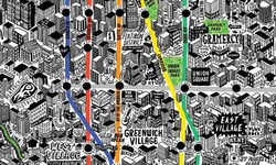 A new book of 75 personal maps of Manhattan is just the latest in a new wave of cartographic creations by artists – both famous and amateur – seeking to put the romance back into this centuries-old art form.
Check them out! http://www.guardian.co.uk/travel/2013/may/15/hand-drawn-map-cartography-new-york 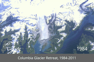 The Google team has compiled a series of Landsat images to show significant changes on Earth over time - Dubai, Columbia Glacier retreat, Las Vegas growth, Amazon deforestation, and more. Very cool!
http://google-latlong.blogspot.com/2013/05/a-picture-of-earth-through-time.html  The FracTracker Alliance is looking for a well-qualified candidate to serve as California Program Coordinator on a full-time basis. This newly created position will be based in the greater San Francisco area. Deadline to apply: May 31, 2013. PurposeThe position will coordinate, manage, and support outreach and analytical activities in California for the FracTracker Alliance. The FracTracker Alliance is a non-profit organization dedicated to enhancing the public’s understanding of the impacts of the oil and gas industry through data collection, mapping, and analysis and by sharing these and other resources on our website, FracTracker.org. We partner with citizens, organizations and institutions – allied in a quest for objective, helpful information – to perpetuate awareness and support actions that protect public health, the environment, and socioeconomic well-being. Duties
Minimum Education / QualificationsBachelor’s degree in natural or physical sciences, environmental studies, public health, economics, agriculture, or other relevant field. Advanced degree preferred. Five years of work experience exercising the skills listed above. Compensation
Questions? Please call (717)-303-0403 or email us.  Abstract
In just under seven years, Twitter has grown to count nearly three percent of the entire global population among its active users who have sent more than 170 billion 140–character messages. Today the service plays such a significant role in American culture that the Library of Congress has assembled a permanent archive of the site back to its first tweet, updated daily. With its open API, Twitter has become one of the most popular data sources for social research, yet the majority of the literature has focused on it as a text or network graph source, with only limited efforts to date focusing exclusively on the geography of Twitter, assessing the various sources of geographic information on the service and their accuracy. More than three percent of all tweets are found to have native location information available, while a naive geocoder based on a simple major cities gazetteer and relying on the user–provided Location and Profile fields is able to geolocate more than a third of all tweets with high accuracy when measured against the GPS–based baseline. Geographic proximity is found to play a minimal role both in who users communicate with and what they communicate about, providing evidence that social media is shifting the communicative landscape. To read the full article: http://firstmonday.org/ojs/index.php/fm/article/view/4366/3654  Making data beautiful - another reason to learn TileMill for web mapping!
To read the full article: http://www.wired.com/design/2013/05/a-cloudless-atlas/  POSITION
A Geographic Information Systems (GIS) Technician position (Research Associate I Special) is available with the Center for Environmental Management of Military Lands (CEMML). This position will provide geospatial technical support to the Wyoming Army National Guard (WYARNG), and will be located at Camp Guernsey, Wyoming. ORGANIZATION The Center for Environmental Management of Military Lands is a research, education and service unit within the Warner College of Natural Resources at Colorado State University (CSU). CEMML applies the latest and most appropriate science to promote the sustainable management of natural and cultural resources on Department of Defense (DOD) and other public lands. We provide technical support, conduct applied research, and offer career development and learning opportunities to support resource stewardship. We collaborate with our sponsors and within CSU to resolve complex environmental issues, leaving a legacy of science-based decisions that sustain our resources for future generations. To learn more about CEMML’s contributions to land management and our mission, vision, and values, visithttp://www.cemml.colostate.edu/. LOCATION Camp Guernsey, established in 1939, is comprised of over 77,000 acres of maneuver land, training ranges, and support facilities utilized and managed by the Wyoming Army National Guard (WYARNG). It is situated along the North Platte River in southeastern Wyoming, approximately 90 miles southeast of Casper and 80 miles north of the state capitol of Cheyenne. The setting offers many opportunities for outdoor recreation. RESPONSIBILITIES The incumbent will function as part of the Sustainable Range Program team to provide geospatial technical support to the Camp Guernsey Joint Training Center, including performance of duties associated with SRPGIS. Provide GIS analysis, map production, and support for the SRP and other WYARNG programs as directed. Inventory, develop, and manage SRP GIS databases. Coordinate with and utilize the Army’s SRPGIS Support Center. Create and maintain geospatial data that is compliant with the standards of the Federal Geographic Data Committee (FGDC) and Spatial Data Standards for Facilities, Infrastructure, and Environment (SDSFIE). Meet with military and other personnel to discuss mapping and database needs. Operate and maintain GIS system hardware, software and peripherals. Collect field data as required. MINIMUM QUALIFICATIONS BS/BA degree in geography or natural resources, or equivalent (4 years) experience working with GIS and geospatial data. Ability to work outdoors in variable terrain and weather conditions. Must have or be able to obtain a valid driver’s license. DESIRABLE QUALIFICATIONS Developed skills in data collection, use of Global Positioning Systems hardware, GIS database development, and metadata development. Demonstrated experience working with GIS applications and digital cartography. Demonstrated knowledge of ArcGIS software and extensions. Knowledge of FGDCmetadata standards and SDSFIE standards desired. Demonstrated experience providing GIS technical support to the Army or Army National Guard. Excellent written and oral communication skills. BACKGROUND CHECK Colorado State University is committed to providing a safe and productive learning and living community. To achieve that goal, we conduct background investigations for all final candidates being considered for employment. Background checks may include, but are not limited to, criminal history, national sex offender search and motor vehicle history. SALARY Salary is commensurate with experience and qualifications, with range of $37,000-$42,000 annually. Continuation of position is dependent on the receipt of funding from the sponsor for the GIS Technician position at Camp Guernsey, WY. BENEFITS Colorado State University offers a generous benefits package including 24 days of paid vacation leave, tuition credits, excellent health insurance (including vision and dental), and retirement plans with 9% matching. For more information on Administrative Professional benefits visit,http://www.hrs.colostate.edu/benefits/. APPLICATION Prospective candidates should apply on-line at https://warnercnr.colostate.edu/jobs/. Apply no later than June 2, 2013, for full consideration. Upload each of the items below individually as a Word Document (.doc),PDF (.pdf), or Rich Text Format (.rtf). Please note that incomplete applications cannot be considered. Please remove social security numbers and birthdates from application materials. A complete application consists of: 1) Statement of Qualifications (cover letter addressing each minimum and desirable criterion in announcement) 2) CV (resume) 3) References (contact information for professional references, including at least one supervisor) Colorado State University does not discriminate on the basis of race, age, color, religion, national origin or ancestry, sex, gender, disability, veteran status, genetic information, sexual orientation, or gender identity or expression. Colorado State University is an equal opportunity/equal access/affirmative action employer fully committed to achieving a diverse workforce and complies with all Federal and Colorado State laws, regulations, and executive orders regarding non-discrimination and affirmative action. The Office of Equal Opportunity is located in 101 Student Services. See a complete listing of open CEMML positions at http://www.cemml.colostate.edu. POSITION #: GUE/GIS/6/2/13  Job Code 131739
Title Environmental Science Intern Job Family Interns Location USA - OR - Portland Company HDR Engineering, Inc. Minimum Experience 0 Description The Portland office of HDR Engineering Inc. is looking for an Environmental Science summer intern to join the Resources Section. The successful candidate will gain a broad range of experience which could include conducting environmental field work, performing desktop research and environmental analyses, and assisting with report generation. Keyword(s): Intern EngineeringRequirementsThe successful candidate must be detail-oriented, and possess strong problem solving and communication skills. Individuals enrolled in undergraduate or graduate program in an environmental sciences discipline, with 3+ years (undergraduate) or 2+years (postgraduate) completed toward their degree, are preferred. A working knowledge of wetland, stream, and/or other environmental survey methods; environmental regulations; botany; GIS; good written and oral communication skills; and ability to learn quickly and motivate with moderate direction are strongly desired for this position. This position may be subject to a pre-employment drug test and drug and alcohol testing during the course of your employment based upon HDR's Drug Testing and Drug Free Workplace Policy. An Affirmative Action Participant EOE M/F/D/V To apply: https://prod.fadvhms.com/hdr/jobboard/JobDetails.aspx?__ID=*2A7198D52C89E5A0  Position: GIS Intern
Location: Portland, Oregon Duration: June 3rd – August 30th, 2013 Salary: $14.50 per hour Company Background: Maul Foster & Alongi, Inc. (MFA) is a locally owned Pacific Northwest consulting firm specializing in the areas of environmental science, engineering, planning, and GIS. Since our inception in 1996, MFA has grown from four employees to over 70 employees, with offices in Portland, Oregon, and in Vancouver, Seattle, and Bellingham, Washington; and Kellogg, Idaho. For over 15 years we’ve provided services to a diverse client base that includes private business and industry, ports, municipalities, state and federal entities, and Native American tribes. We are committed to a better planned and well-designed future. Position Description: MFA is seeking a full-time GIS Intern for the 2013 summer for our Portland, Oregon, office. The successful candidate will be responsible for providing GIS technical support for environmental, planning, and conservation related projects. Primary duties include assisting with day-to-day GIS project tasks for company projects, including GIS data management, collecting, analyzing, and mapping geographic data, and creating cartographic products for display and reports. Secondary duties will include assisting with assigned research and ongoing ArcServer development tasks. To Qualify: Minimum Requirements
Desired Skills and Abilities
How to Apply: To be considered for the position, please follow the link below: http://maulfoster.iapplicants.com |
Categories
All
Archives
June 2024
|
 RSS Feed