 Portland Public Schools (PPS) seeks a qualified Geographic Information Systems (GIS) Specialist intern to work on a half-time basis through June 30th, 2015. The internship will start on or before Monday April 13th, 2015.
This is a great opportunity to work on an Active Transportation planning project that spans 2,306 miles of routes to school within a 152 square mile service area that includes portions of unincorporated Multnomah County, as well as portions of Clackamas and Washington Counties. The project will benefit over 45,000 students served by the District. POSITION DESCRIPTION The intern will support a GIS Planning Specialist and produce spatial and non-spatial data/information relevant to pedestrian network analysis, student walk-area assessment, and student walk route finding. The intern will produce maps and report graphics. Field verification of data and mapping is required. This is a paid, limited term position and renewable for up to three months dependent on available funding. PPS will provide a workstation and all required software to complete assigned tasks. The individual in this position must demonstrate understanding and compliance with PPS policies and procedures, and applicable rules, regulations and laws. The position requires a criminal background check and reference check. QUALIFICATIONS Education. Required:
Preferred:
Experience:
Technical Job Related Knowledge, Skill, Abilities:
Registrations, Certifications and/or Licenses:
Other:
Please send a letter of interest, current resume, and two references to: Justin Fallon Dollard, PPS Planning and Asset Management jdollard@pps.net no later than 5pm, Friday April 3rd, 2015. The position will remain open until qualified applicants are identified. This position may close early. General inquires and questions should be sent to: jdollard@pps.net. Join PDX-OSGeo for the March meeting Wednesday February 18th at 6pm in Cramer Hall (Room 409, Portland State University)
Details on Calagator: http://calagator.org/events/1250468044 Bring whatever geo-awesomeness you want to discuss this month. Come hear Justin Miller talk about Mapbox GL for JavaScript, "which despite being in active development, is totally usable for certain projects". The particular project he built out is a travel choropleth map with dynamic interaction-based styling, all rendered as vectors in the browser. Rumor is there will be pizza, and as always, BYOB,  There are three open GIS positions in the Global Forest Watch initiative at the World Resources Institute:
GFW Data & Website Research Assistant Location: US-DC-Washington Program: Food, Forest, and Water (FFW) Type: Regular Full-Time Global Forest Watch GIS Research Analyst I Location: US-DC-Washington Program: Food, Forest, and Water (FFW) Type: Regular Full-Time Global Forest Watch GIS Research Analyst II Location: US-DC-Washington Program: Food, Forest, and Water (FFW) Type: Regular Full-Time Please also see the WRI Careers page – we have 10 open positions in Washington, DC or our international offices that require GIS knowledge or experience (search by keyword GIS). Please apply online to any position; only applications submitted through the WRI Careers portal will be considered. Are you an experienced GIS professional looking for a unique opportunity that'll allow you to do what you love, and be a part of a major company driving progress and innovation?
Do you enjoy working for an organization at the front line of improving the lives of others? If you answered yes to the above and would like to learn more about this great opportunity, then this is the role for you! Our client, a large, well known Utility company, is currently seeking a GIS Technician for a 4 month, temporary and contract role and immediate need. This role may have the opportunity to extend or convert depending on performance, budget and project scope, however this cannot be guaranteed. Candidates must: - Have all of the following: - Have at least 1 year of progressive and on the job experience in ArcGIS Desktop 10.0. - Have hands on experience and be knowledgeable in ArcFM (this is a MUST HAVE). - Be proficient in ArcSDE. - Have hands on experience in editing using ArcFM, feeder tracing, as well as Session Manager or similar. - Must have EXCELLENT communication skills. - Degree is not required. - Be a strong team player, with the ability to work well independently as well as collaboratively. Nice to haves (not required): - Previous experience working in Utilities. This opportunity is being offered through Kforce. If you are interested in being considered and would like additional details, please contact Camilo Forero at Cforero@kforce.com immediately and refer to job #1411335.  Background
Deer Creek Resources (DCR) provides onsite cartography, printing, data management, networking, and tech support during major wildland fires and other emergency incidents across the American West. We are accepting applications for the 2014 wildfire season. Applicants must reside in CA, OR, or UT. This is a call-when-needed position, with no guarantee of assignments or minimum term of employment. However, if we do have assignments, we work up 112 hours per week, and you will make good money.Job Description Successful applicants will operate DCR's Mobile Mapping Support Modules on large wildfires, natural disasters, and pre-fire planning projects. Technical tasks may include:
This job also requires a wide variety of mechanical and problem-solving skills. A typical assignment may require setting up acomputer network in an alfalfa field, fueling a generator by headlamp, rewiring a trailer-brake hookup on the side of the highway, securing loads and towing generators or trailers, repairing equipment, ordering supplies, and completing daily invoices. We are looking for flexible, talented people who are comfortable bathing in a converted semi-trailer, or eating tough steaks with inmates in a big circus tent. Requirements Our job is to provide reliable equipment and a steady hand way out in the sticks, without any backup. In addition to solid GIS/IT skills, we need people who can build a computer from parts or fix a broken printer using common household items. Expert computer-driving skills and a mastery of ESRI ArcMap software are required, and fieldwork experience can't hurt. A large personal library of energetic and tolerable music is a plus. Driving is required. Availability Successful applicants must be available for 7 day assignments between June and October. Work is in 16 hour shifts for up to 14 days. Tent camping is required on many assignments. All travel expenses are paid. We are especially interested in hiring people who can be available on very short notice (within 6-12 hours) between July 15th and September 15th. Responding to this Announcement 1. Email us a cover letter and current resume, including references. 2. Send examples of your cartography work (web links are preferred). 3. Please include something in the subject line that lets us know that you are not a robot. Candidates may be required to complete a practical GIS skills test as part of the application process . This Wednesday March 11th happens to be the 2nd Wednesday of the month. Meaning it is time to gather to talk about GIS, Conservation, and other things while working through the tap list at Green Dragon.
Green Dragon Bistro and Pub 928 SE 9th Ave 5:30'sh  The City of Troutdale, Oregon is currently seeking applicants for the position of:
GIS Analyst Application Deadline: March 18, 2015 Compensation: $25.65 to $29.68 (DOE) General Description: Perform a variety of technical tasks related to geographic information systems, cartography, technical drawing and information technology. Design, integrate, manage and maintain a complete City GIS. Produce custom maps, exhibits and datasets from GIS and related tools. In collaboration with the City's Information Services Division, integrate and maintain GIS hardware and software on desktop, mobile and server computer systems within the Public Works Department to ensure their efficient functionality and compatibility with the City's local area network, mobile devices, network security and computer usage policies. Continuously research current GIS technologies and make recommendations with respect to the purchase and integration of new software and hardware. Provide technical support to City personnel related to GIS. Qualifications: Knowledge of: Geography, Cartography and/or Land Surveying Current GIS technology and processes; and GIS planning, design, integration and deployment ArcGIS software family (desktop, server and online), Trimble mobile software and other mapping and GIS software HTML (or web-authoring applications) and Python programming environments Microsoft Access, SQL server and/or other enterprise database systems. Geographic Positioning Systems and related remote sensing and data collection technologies GIS server, PC and mobile computing technology (Apple, Android and Trimble), including architecture, security, software and hardware installation, and maintenance. Basics of Microsoft Server operating system Ability to: Manage and maintain a complete GIS including software and hardware components Produce high-quality maps, exhibits, datasets and reports using GIS Perform geospatial analysis using GIS Integrate digital photography, LiDAR and other remote sensing data with GIS Quickly assimilate knowledge of new and existing digital technologies Manage multiple enterprise databases and links to external databases Install, configure and deploy a variety of server-based and client-based GIS software Communicate effectively orally, graphically (maps and exhibits) and in writing. Required Education and Experience: Bachelor's Degree in Geography, Cartography, Civil Engineering, Computer Science, Urban Planning or other closely related field(s). Must have at least three years of professional work experience in Geographic Information Systems development, programming, map production, project management and/or closely related functions; or any satisfactory combination of experience and formal education that demonstrates the ability to perform the above duties. Preferred: Prior experience in the Public Sector. Special Requirements: Valid driver's license and acceptable driving record. Please see the complete GIS Analyst job announcement at www.troutdale.info for full details regarding the essential job functions and required qualifications associated with this position. To apply for this position: 1) Pick up an application packet (8 am -- 5 pm, M-F) from the Receptionist at Troutdale City Hall, 219 E. Historic Columbia River Hwy., Troutdale, OR 97060, or 2) Download the application packet from the City's Web Page at www.troutdale.info/employment and submit as indicated, or 3) Request an application packet be mailed to you by calling the Receptionist at 503-665-5175 To submit applications materials for this position: Mail or deliver application materials to: Human Resources City of Troutdale 219 E. Historic Columbia River Hwy. Troutdale, OR 97060 Fax application materials to: Human Resources 503.208.7103 Email application materials to: HR@troutdaleoregon.gov The City of Troutdale is an equal opportunity employer and does not discriminate on the basis of race, religion, color, sex, age, national origin, disability, veteran status, or any other classification protected by law.  Clean Water Services is looking for a university intern (6 month duration, flexible hours).
The Watershed Management Department within Clean Water Services is hiring a temporary university intern. The job posting is here This position is an excellent opportunity for a current or recently graduated student to develop GIS experience working for a nationally-recognized stream restoration program in the public sector. The ideal candidate is a self-motivated, ecologically-minded individual with a strong desire to learn new skills in GIS and data management. Additional Internship Information: · Temporary position for a maximum of six months · Flexible schedule: part-time up to full-time (24-40 hours per week) Link to Internship Posting Applicant questions and such can be routed through the HR contact on the posting.  Umatilla Electric Cooperative, headquartered in Hermiston, Oregon, has an opening for a Geographic Information Systems (GIS) Administrator. Under the direction of the Engineering Department Manager, this position is responsible for the activities of the Cooperative’s geographic information system. Among other duties, this includes ensuring the electrical system model, database, connectivity, and geographic base map are accurate and current and optimizing field and departmental GIS applications to meet the Cooperative’s needs.
A complete description of the position is attached and can be found at https://www.umatillaelectric.com/about/career-opportunities/. UEC offers a competitive wage and benefits package. Applications may be obtained online, in person at 750 W Elm Ave, Hermiston, OR, by email at hr@umatillaelectric.com, or by calling (541) 289.0380. Closing date is 3/26/15. EOE M/F/Disability/Veteran. 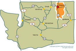 Ferry County in Republic, WA is looking for a GIS Specialist.
http://www.ferry-county.com/Employment.html |
Categories
All
Archives
March 2024
|
 RSS Feed