|
ASPRS Scholarship Application Tips! Want insight on applying for ASPRS scholarships? Come to our event on October 4th from 2-3pm! We will have ASPRS representatives present to answer any and all questions. And, we will have a past scholarship winner to provide insight! Register here! Scholarship Application Tips (asprs.org) - be sure to log in! When: October 4th, 2pm-3pm Where: zoom 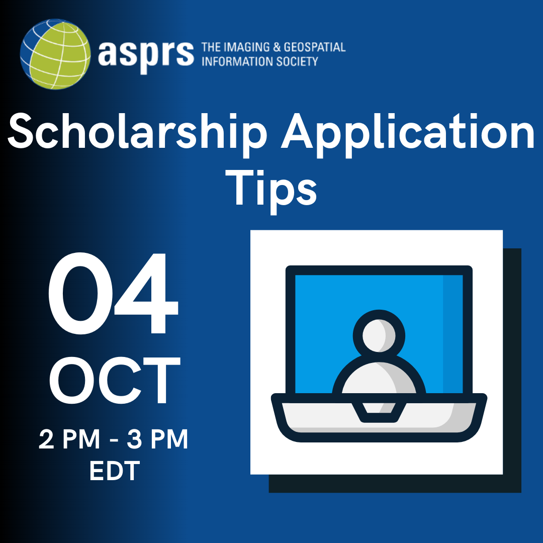 More info on ASPRS scholarships:
ASPRS is pleased to offer ten scholarship awards totaling more than $38,000 in value! Available to both undergraduate and graduate student members of ASPRS, these resources have been generated with the intention of advancing academic and professional goals in the geospatial sciences. ASPRS recognizes that students are the future of these rapidly evolving fields and encourages all who are qualified to take advantage of these unique opportunities. Scholarship Application Window: September 22 – November 8 Letters of recommendation due November 12 More info here: ASPRS Awards and Scholarships – ASPRS ASPRS Webinar: Why Join ASPRS? Attendees will be entered into a raffle to win a free 1-year ASPRS membership! Day/Time: September 15 @ 7:30pm EST Register here (please make a free ASPRS account to register. Registration is also free): https://my.asprs.org/ASPRSMember/Events/Event_Display.aspx?EventKey=SAC21080 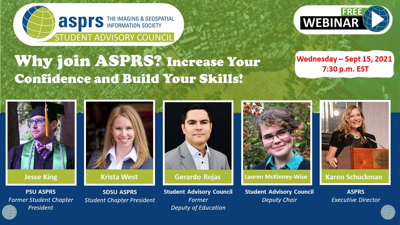 A panel of ASPRS members will share their ASPRS journey and discuss how ASPRS and engaging in the GIS and remote sensing community can help boost your confidence and build your professional network.
Panel members include ASPRS student chapter presidents, members of the ASPRS Student Advisory Council and ASPRS's current executive director. Join us to create new professional connections and to learn about ASPRS resources! Please share with students and folks interested in getting involved in their geospatial communities! 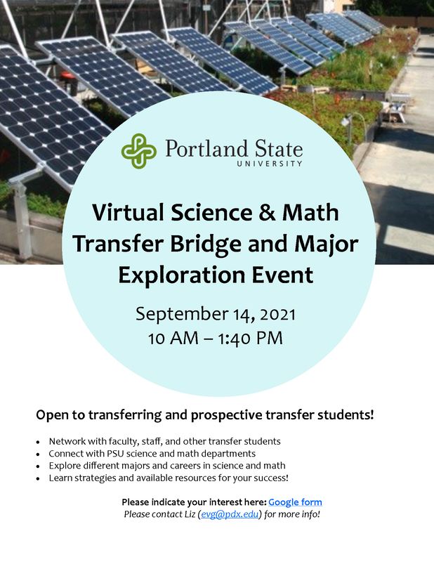 The PSU College of Liberal Arts & Sciences will be hosting a first annual college-wide Science & Math Transfer Bridge and Major Exploration event on September 14th. The event is designed both for students who plan to transfer in fall and for those who aren't yet ready to transfer and may still be exploring majors. During this virtual event, students will have the opportunity to learn more about programs and resources available to PSU's large transfer population, connect with faculty and current PSU students, and learn more about the following CLAS majors: Anthropology, Biology, Chemistry, Environmental Science/Environmental Studies, Geography, Geology, General Science, Math/Statistics, and Physics (see draft agenda below). 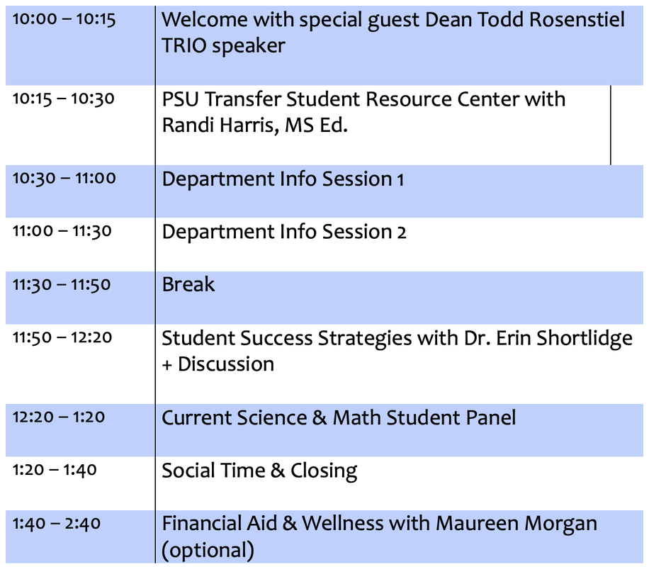 ASPRS Webinar: Why Join ASPRS? A panel of ASPRS members will share their ASPRS journey and discuss how ASPRS and engaging in the GIS and remote sensing community can help boost your confidence and build your professional network. Panel members include ASPRS student chapter presidents, members of the ASPRS Student Advisory Council and ASPRS's current executive director. Join us to create new professional connections and to learn about ASPRS resources! Please share with students and folks interested in getting involved in their geospatial communities! Day/Time: September 15 @7:00pm EST (NEW DATE!) Register here (please make a free ASPRS account to register. Registration is also free): https://my.asprs.org/ASPRSMember/Events/Event_Display.aspx?EventKey=SAC210804 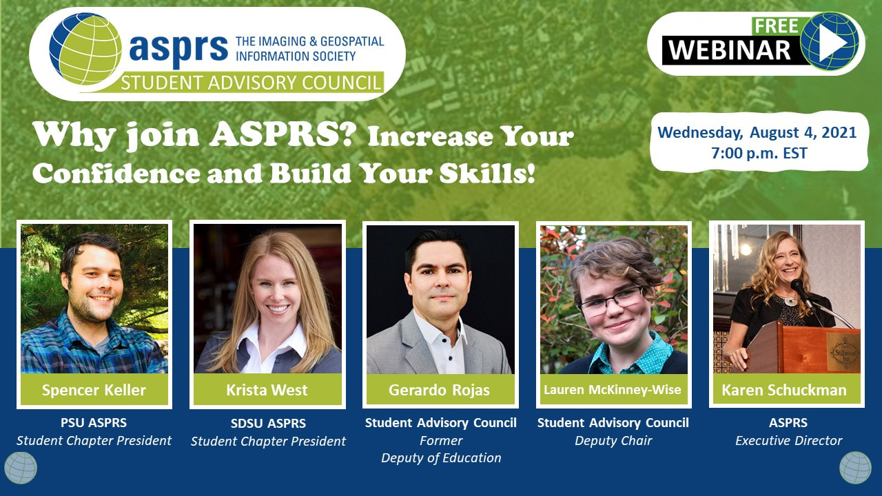 https://www.eventbrite.com/e/talkin-water-willamette-water-supply-system-interactive-mapping-tool-tickets-145575368847
Join us March 24 from noon - 1 p.m. to learn how Willamette Water Supply System construction information is being provided visually About this Event Do you have a student who is interested in maps and interactive online technology? Curious how you can learn more about the Willamette Water Supply System, one of the main drivers of your water rates? Scott Fortman, Geographic Information Systems Analyst will demonstrate visually the large diameter pipeline which will be used to bring water from the Willamette River to customers starting in 2026 via ESRI ArcGIS. Flyover views, interactive text and points of interest are enhanced features of the map created using ESRI ArcGIS, one of the leaders in the software mapping industry. Join us on March 24 to get a peek at this exciting new tool. https://consbio.org/newsroom/events/scgis-webinar-building-relationships-matter-geospatial-career-success
Register here: https://zoom.us/webinar/register/WN_Ni3MtzN-TuOM4JUhQPDg6w Date/time: Thursday, March 18 at 10am PT Presenter: Eva Reid, MPA, GISP is a Senior GIS Analyst in the DC Metro area Description: In the world of GIS it is important to make personal connections to get the job done. The most successful people are often also those who rely heavily on the power of networking. Unfortunately, networking can be exhausting and is probably the last thing that you want to do after a long day. In this session you will learn about building relationships authentically, even while working remotely, and how you can leave the impersonal, transactional nature of networking behind. Bio: Eva Reid, MPA, GISP is a Senior GIS Analyst in the DC Metro area with 25 years of experience in GIS, information technology, training and project management. Eva also owns a consulting business, Eva Reid Consulting, LLC, offering professional development opportunities to women in technology. The Center for Spatial Studies Lightning Talks are designed to be serious or funny, as long as the mantra is followed: “Enlighten us, but make it quick.” This year these 3-minute talks will be held on Tuesday, March 16, 2021 from 10:00 to 11:30 a.m. (PST).
If you would like to attend this light-hearted, thought-provoking event, please RSVP and register here. [ucsb.zoom.us] Our panel of speakers this for the 2021 Spatial Lightning Talks is: Michael Goodchild (Emeritus, Dept of Geography, UCSB) “You are here” Gabriela Morosanu (Inst. of Geography of the Romanian Academy) “Fine sediments sources and coal mining: Spatial-temporal inference” Menno-Jan Kraak (Geoinformation Sciences & Earth Observation, Univ. of Twente) “How an advertisement made me think about space and time” Anna Lopez-Carr (Direct Relief) “Mapping applications for post-disaster learning in Puerto Rico” Xiang Ye (Shenzhen Univ.) “There is a reason for ‘geospatial’” Ronnie Bailey-Steinitz (Dept. of Anthropology, UCSB) “The forest or the trees: Scaling measurements on food availability” Michael Kilburn (Politics & International Studies, Endicott College) “Geosophy” Monica Castelhano (Dept. of Psychology, Queen’s Univ.) “Exploring real-world scenes: Semantics and functions of everyday spaces” Lexie Kunz (Dept. of Psychological & Brain Sciences, UCSB) “GPS usage and its effect on spatial navigation” Qingyu Ma (Old Dominion Univ.) “Satellite maps tell a lot” Ashley Kuder (Dept. of Geography, UCSB) “Saving birds from window collisions, one building at a time” Alexis Story Crenshaw (Media Arts & Technology, UCSB; Université Paris 80 “Spatial expression approaches in electro-somaesthetic music” Katy Börner (Dept. of Intelligent Systems Engineering, Indiana Univ.) “Human [reference] map” André Skupin (San Diego State University; Center for Info. Convergence & Strategy) “Yes, there’s a map for that!” Stephen Hirtle (Emeritus, School of Computing & Information, Univ. of Pittsburgh) “Why is it not a cognitive map?” Jayden Schultz (Dept of Geography, UCSB) “The norming of space” Andrew Schroeder (Direct Relief) “Mobility data for emergency response You can see the agenda at http://spatial.ucsb.edu/2021-lightening-talks/ [spatial.ucsb.edu]. How to Discover Your GIS Career Niche Featuring National Geographic Explorer Dr. Maria Fadiman3/3/2021
How to Discover Your GIS Career Niche
Featuring National Geographic Explorer Dr. Maria Fadiman This webinar series highlights women in geospatial fields and provides a platform to tell their unique professional growth stories and career paths. This guided discussion will cover the speaker’s career challenges, current projects, and career growth. In this webinar, two time TEDx speaker and National Geographic Explorer, Dr. Maria Fadiman will discuss the evolution of her career in working with cultural and ecological conservation. Her stories will cover how success is not always a straight path, how to tell your unique story, and how to use your own skills to grow professionally. Learn about her global travels, her work with indigenous tribes and their relationship to the environment, and how geography can be applied to exploration. In this webinar you will:
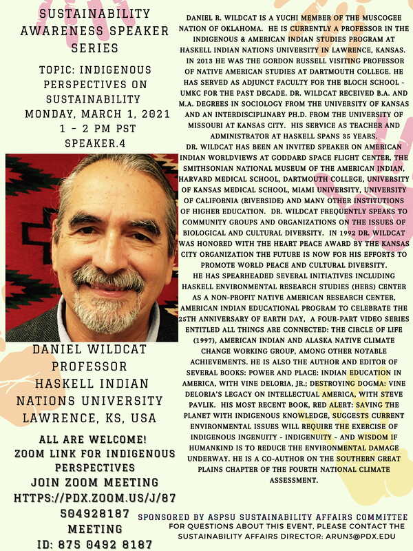
Register For This Webinar This live webinar event is FREE and open to the public Instructor: Dr. Maria Fadiman Professor Florida Atlantic University and National Geographic Explorer Date: Monday, March 29 Time: 11:00AM-12:00pm Pacific If you are unable to attend the live webinar please still register. All registrants will receive a recording of the live webinar and a copy of the PowerPoint slide deck the next business day. Sustainability Awareness Speaker Series: Indigenous Perspectives on Sustainability. Monday 3/1 @ 1pm2/25/2021
 Message from Rebecca Degagne at SCGIS (Society for Conservation GIS):
We hope you're staying well and will join us for our upcoming SCGIS-CBI Webinar Series, which kicks off in two weeks. We have a wonderful line-up, featuring a diverse group of speakers with presentations on using citizen science data to monitor threatened species, tracking land degradation with remote sensing, building relationships for career development, creating partnerships with Indigenous communities, and mapping bird migrations and threats. If you register for a webinar and can't make the live presentation, you'll be sent a link to the video recording to watch at your convenience. The whole recording archive can be accessed here: https://scgis.org/webinar/index/past/1. SCGIS-CBI 2021 Spring Webinar Series: March 4th, 10 AM - 11 AM Pacific Using community science to predict extinctions and monitor threatened species Peter Soroye, University of Ottawa. REGISTER: https://consbio.org/newsroom/events/using-community-science-predict-extinctions-and-monitor-threatened-species March 11th, 10 AM - 11 AM Pacific Measuring progress in land condition from space with Trends.Earth Gabriel Daldegan, Moore Center for Science at Conservation International REGISTER: https://consbio.org/newsroom/events/scgis-webinar-measuring-progress-land-condition-space-trendsearth March 18th, 10 AM - 11 AM Pacific Building Relationships that Matter for Geospatial Career Success Eva Reid, Eva Reid Consulting, LLC REGISTER: https://consbio.org/newsroom/events/scgis-webinar-building-relationships-matter-geospatial-career-success April 1st, 10 AM - 11 AM Pacific Building Effective Partnerships with Indigenous Communities James Rattling Leaf, Sr., Group on Earth Observations Indigenous Alliance REGISTER: https://consbio.org/newsroom/events/scgis-webinar-building-effective-partnerships-indigenous-communities April 8th, 10 AM - 11 AM Pacific Mapping Bird Migrations and Threats Across the Western Hemisphere Erika Knight & Lotem Taylor, National Audubon Society REGISTER: https://consbio.org/newsroom/events/scgis-webinar-mapping-bird-migrations-and-threats-across-western-hemisphere We make our webinars free & open to everyone, so please share these links with your networks and consider joining SCGIS as a member, to support our work. We're also planning on holding more SCGIS-CBI mixer-style meetups later in the year at rotating times, so folks from around the world can join in. If you want to fast-track your involvement in the conservation community, volunteer for SCGIS! - Reliable people with time to contribute (though fall 2021, at least) are especially needed to support our virtual SCGIS Conference activities. If you're interested in volunteering for the Conference Committee, please email vsclater@scgis.org. |
Categories
All
Archives
March 2024
|
 RSS Feed