|
https://careers-nv5.icims.com/jobs/9724/summer-intern/job
Overview NV5 is a global technology solutions and consulting services company with a workforce of over 4,500 professionals in more than 100 offices worldwide. NV5’s continued growth has been spurred through strategic investments in firms with unique capabilities to help current and future customers solve the world’s toughest problems. The NV5 family brings together talent across a wide range of markets and fields, including Professional Engineers, Professional Land Surveyors, Architects, Photogrammetrists, GIS Professionals, Software Developers, IT, Project Management Professionals, and more. At NV5 Geospatial, We are a collaboration of intelligent, innovative thinkers who care for each other, our communities, and the environment. We value both heart and head, the diversity of our people, and their experiences because that is how we continue to grow as a leader in our industry and expand our individual and collective potential. Interns will aid in the processing of remote sensing/GIS data, and general operational efforts, to support projects and team functionality. This individual will learn to produce accurate and precise data products in a consistent and timely manner and should have a strong interest in the geospatial field. The opportunity is meant to introduce them to geospatial production workflows, remote sensing technologies and tools, and provide on-the-job experience and professional skill building. Responsibilities Responsibilities:
Opportunities:
Knowledge, Skills, and Abilities:
Qualifications Minimum Qualifications:
Preferred Qualifications:
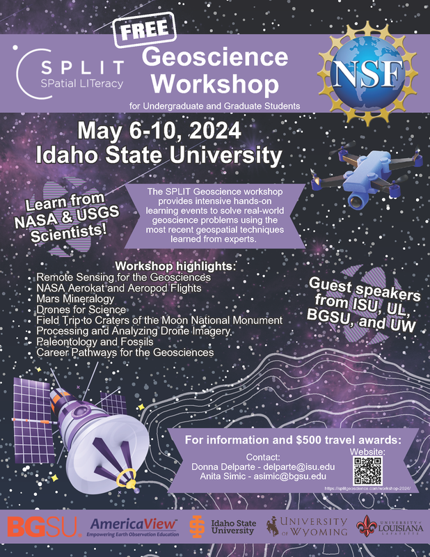
Please include a letter of interest, resume and a list of professional references in one document. NV5 offers a competitive compensation and benefits package including medical, dental, life insurance, PTO, 401(k) and professional development/advancement opportunities. The SPLIT Geoscience workshop provides intensive hands-on learning events to solve real-world geoscience problems using the most recent geospatial techniques learned from experts. This workshop is for undergraduate and graduate students and is being hosted at Idaho State University. It is a collaborative project between OhioView, LouisianaView, and IdahoView. The workshop is being held in-person from May 6-10 and there are several travel grants available to help with travel costs. Contact Anita Simic-Milas if you have any questions, [email protected].
https://secure.collage.co/jobs/terraremotecareers/43904
Position Description It is an exciting time with Terra Remote Sensing Inc USA. Terra is seeking a full-time Aerial Geomatics Technician, QC to join the Field Operations Team to support our growing US project work by ensuring field data acquired is correct and accurate. The Aerial Field Survey Team focuses primarily on LiDAR and aerial image data acquisition, data validation, analysis as well as processing of results. This role is ideal for a recent graduate who resides in the Pacific Northwest, United States, has a home office and is able to travel for projects. Training is provided. Responsibilities Reporting to the Aerial Field Operations Manager and working closely with the lead Field Operator, responsibilities include (but are not limited to): · Real-time and post-acquisition data analysis; quality control to ensure completeness and that high-quality data is surveyed and maintained throughout a project lifecycle, · Acquisition of aerial remote sensing data – LiDAR, photography, meteorology, GPS, INS and other sensor data, as required, · Logistical planning and execution support, including: coordinating equipment preparation, mobilization checklists, process forms, flight planning, · Support Field Operator to proactively perform maintenance and testing in order to ensure proper working condition of equipment – hardware, firmware, software and interdependencies, · Support for the development of standard operating procedures (SOPs), work instructions, health and safety training and documentation relevant to the Aerial Field Survey Group, · Learn and support other data production groups as requested during stand-by periods. Qualifications/Skills: · Experience with remote sensing data, surveying or/and mapping either job related or through a school program. Experience with LiDAR, orthophotography, GPS, INS, calibration and data processing are deemed assets. • College level coursework in a Geomatics related field. A two or four-year degree is preferable. · Willingness to learn and be trained in LiDAR processing software, INS positioning, and image interpretation. Willingness and ability to travel frequently and sometimes for long durations. · Experience with prioritization, multi-tasking, and troubleshooting independently while working in remote areas. · Excellent verbal and written communication skills. · Strong organizational skills and aptitude for following process. · A valid and clear criminal record check is required upon hire. · Dual citizenship for US/Canada considered a significant asset. · Valid Driver’s License required. Job Classification Location: Pacific Northwest United States Preferred Remote with 75-80% travel Job type: Full-time Additional Information Compensation/benefits: Salary will commensurate with skills, qualifications and experience. Terra is an equal opportunity employer, committed to the principle of equity in employment. Relocation will not be provided for this position. If you are interested in applying for this opportunity, please attach your resume and cover letter. For additional information please visit our website at http://www.terraremote.com/ What is Esri Young Professionals Network?
We are a network focused on community building and professional growth and empowerment. This network is ideal for students and recent graduates in need of connecting with peers, industry leaders, and mentors in the geospatial community. We facilitate growth opportunities for students, such as virtual networking events, webinars, conference activities, career resource content, and a YPN Ambassador Program. What are the benefits of joining?
How can students join? https://oregon.wd5.myworkdayjobs.com/en-US/SOR_External_Career_Site/details/Senior-Survey-Analyst---Remote-Sensing_REQ-147418?hiringCompany=47688ccd4cac014f570a979ec2233d33
Initial Posting Date: 01/26/2024 Application Deadline: 02/12/2024 Agency: Department of Transportation Salary Range: $5,061 - $7,845 Position Type: Employee Position Title: Senior Survey Analyst - Remote Sensing Job Description: Civil Engineering Specialist 2 – Senior Survey Analyst – Remote Sensing Oregon Department of Transportation Delivery & Operations Division – Engineering & Technical Services Branch Engineering Automation Section / Geometronics Unit Salem The role: Our Engineering Automation Section is recruiting for a senior survey analyst to join our remote sensing team! In this role, you will coordinate and support field and office operations in the collection and processing of various survey data including mobile, static and Unmanned Aircraft Systems (UAS) aerial LiDAR data; single-beam hydrographic data; UAS aerial imagery; and Ground Penetrating Radar (GPR). You will play a key role in researching, analyzing and developing remote sensing products and supporting our surveyors statewide in project delivery. Apply today! We encourage people from all backgrounds to apply for our positions and hope you will join us on our path to diversity, equity, and inclusion. We are an agency that embraces social equity through our values, strategic planning, and actions. Leaning into our equity priorities means we continually examine what we do, the impact we have, and our progress toward weaving social equity into who we are. To learn more about our social equity commitments, visit our Social Equity website. Before applying, click here to visit our applicant information website to learn more about our process. If you are a current State of Oregon employee, you must apply through your employee Workday profile. A day in the life:
What’s in it for you:
Want to know about new job postings? Subscribe to receive weekly email notifications! Minimum qualifications: Five years of civil or transportation-related engineering or surveying experience. One year of this experience must have been independently planning and completing assignments; OR A bachelor's degree in civil engineering, surveying or transportation-related engineering and two years of civil or transportation-related engineering or surveying experience; OR An equivalent combination of education and experience. Special qualifications: Driving is an essential function of this position. You must have a valid driver license and an acceptable driving record. We will conduct pre-employment driving records checks on our final candidate(s). Your license does not have to be issued in Oregon to be considered. What we’d like to see: If you have these attributes, let us know in your application materials! It's how we will choose whom to move forward! You do not need to have all these qualities to be eligible for this position. We may also use transferable skills, experience, education and alignment with ODOT values to help us decide who will move forward.
https://www.ziprecruiter.com/c/Portland-General-Electric/Job/Undergraduate-Technical-Intern-Remote-Sensing,-GIS-Intern-(CS)/-in-Portland,OR?jid=b53faa2ca10e88d0&lvk=o5cJZ_PGXqWSNjj9W0tGeQ.--Mvg-LtGmB
At PGE, our work involves dreaming about, planning for, and realizing a smarter, cleaner, more enduring Oregon neighborhood. Its core to our DNA and we haven't stopped since we started in 1888. We energize lives, strengthen communities and drive advancements in energy that promote social, economic and environmental progress. We're always on the lookout for people passionate about leading and being a part of teams that are advancing innovative clean energy solutions that are also affordable and accessible to all. This is a temporary position that may last up to 6 months. PGE's internship program allows its participants to gain professional learning that offers meaningful, practical, work-related experience while providing support for the organization. Job Function Technical: Provides support in the areas of science, technology, and mathematics. The GIS and Remote Sensing teams are directly responsible for operational efficiencies, customer reliability, and environmental monitoring and impacts. The department supports all of PGE on a variety of GIS applications and is comprised of GIS technicians, mapping analysts, general GIS analysts, and the remote sensing program. This is a great opportunity to understand how GIS is applied in the utility industry as well as an opportunity to build connections with expert GIS professionals and gain experience working in a technical team. Due to the variety of projects, this is great insight and training in a broad range of GIS applications. You will work on a variety of remote sensing/GIS projects including but not limited to: data collection and management, cartography, geospatial analysis, and geospatial web applications In this role you will...
Key Responsibilities
Education/Experience/Certifications
Competencies (Knowledge, Skills, Abilities) Functional Competencies
General Competencies
Physical and Cognitive Demands Cognitive Level Basic: Competencies needed to use common sense to carry out simple or uninvolved instructions and pass initial screening.
Schedule/Attendance
Physical Capabilities
Compensation Range: $16.00 - $36.00 Actual total compensation is commensurate with experience, skills, and education PGE believes in rewarding dedicated performance. We provide a total rewards package that is designed to reward your contributions to the company, and, at the same time, support your well-being and professional development, both now and into the future. To find out more, click here. Join us today and power your potential! Assisting with storms or other Company emergencies is a part of all positions at Portland General Electric. PGE is committed to diversity and inclusion in the workplace and is an equal opportunity employer. PGE will not discriminate against any employee or applicant for employment based on race, color, national origin, gender, gender identity, sexual orientation, age, religion, disability, protected veteran status, or other characteristics protected by law. PGE does not discriminate on the basis of disability. We recognize individuals have a variety of abilities to offer and we believe there is much to value and celebrate by incorporating different abilities into the work we do. One very important way we live this out is in our application and interview process. We work hard to support individuals who may need an accommodation to fully participate in these processes. If you feel you may need an accommodation, or would like to request one, please notify the Talent Acquisition Specialist (Recruiter) associated with the job posting. You may also make this request by contacting [email protected] or by calling 503-464-7250. The Recruiter will provide information and next steps for the accommodation process. Our Diversity, Equity & Inclusion (DEI) team is also available for support. You can contact them at [email protected]. To be considered for this position, please complete the following employment application by the posting close date. Posting closes at midnight (Pacific Time) on the closing date below. If no date is listed, job is open until filled. May 26, 2023 https://careers-nv5.icims.com/jobs/7684/remote-sensing-technician/
Overview NV5 is a provider of engineering and consulting services to public and private sector clients, delivering solutions through six business verticals: Testing, Inspection & Consulting; Infrastructure; Utility Services; Environmental Health Sciences; Buildings & Program Management; and Geospatial Technology. With offices nationwide and abroad, NV5 helps clients plan, design, build, test, certify, and operate projects that improve the communities where we live and work. As engineers, architects, construction/program managers, environmental professionals and beyond, we play a significant role in shaping our communities through the services we provide. We are looking for passionate, driven individuals to join our team focused on Delivering Solutions and Improving Lives. NV5 offers a competitive compensation and benefits package including medical, dental, life insurance, PTO, 401(k) and professional development/advancement opportunities. Description The Remote Sensing Technician (RST) acquires airborne and Geodetic ground survey data. The RST is a field based position that collects aerial survey data with topo and bathymetric LIDAR as well as thermal, hyperspectral, and multispectral imagery sensor systems throughout North America. Alternatively, the RST will be collecting ground data using GNSS survey tools, water monitoring tools, thermal loggers, spherical camera, and mobile LIDAR mapping systems. In the aerial application the RST’s work closely in a collaborative team environment with a captain in small aircraft/helicopters while flying acquisition missions. When collecting control on the ground, the RST will work in a solo environment in remote locations. Examples of collection areas would be urban roads, deep forest, mountainous, agriculture, and riverine environments. RST's configure and monitor sensor systems, track acquisition progress, download/process/ship geospatial datasets to production offices. Responsibilities
Qualifications Minimum Qualifications
Preferred Qualifications
This position reports to the acquisition management team with primary hangar and survey locations in Oregon, Wisconsin, and Virginia. This position will function as a remote position but the employee is responsible for transportation to a medium or large hub primary commercial airport at which point company provides onward travel to and from work locations throughout North America. This position is included in the company’s hearing conservation program. All job offers with NV5 Geospatial are contingent upon passing a background check and drug screening. NV5 provides equal employment opportunities (EEO) to all applicants for employment without regard to race, color, religion, gender, sexual orientation, gender identity or expression, national origin, age, disability, genetic information, marital status, amnesty, or status as a covered veteran in accordance with applicable federal, state and local laws. NV5 complies with applicable state and local laws governing non-discrimination in employment in every location in which the company has facilities. This policy applies to all terms and conditions of employment, including, but not limited to, hiring, placement, promotion, termination, layoff, recall, transfer, leaves of absence, compensation, and training. https://sanborn.hrmdirect.com/employment/job-opening.php?req=2347963&jbsrc=1024&_=1673973114
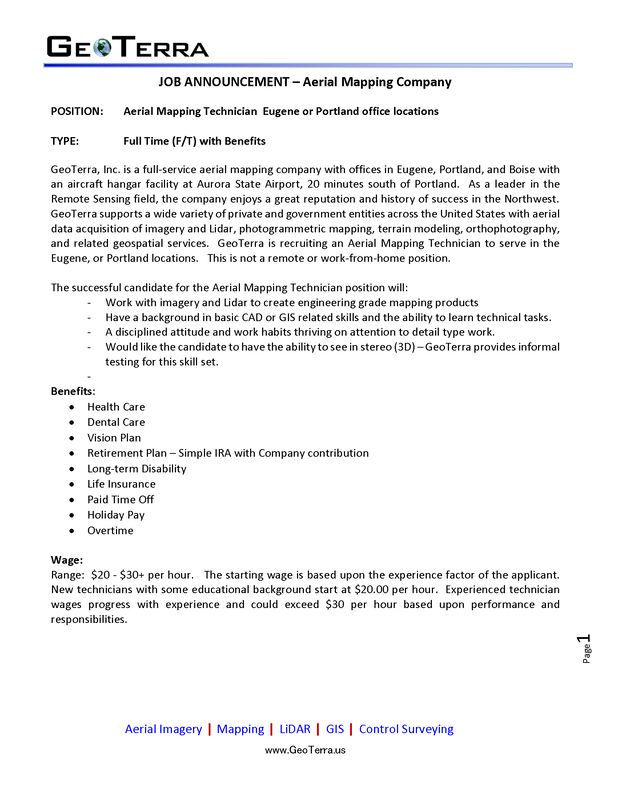
Sanborn Map Co. is looking to fill an on-site Geospatial contractor position with the Bureau of Land Management as soon as possible. The job is in Denver, so any applicant would need to be able to be based there. This position will work within the BLM's Geospatial Imaging Section, which leads the Bureau in geospatial science, photogrammetry and remote sensing. There are a lot of great opportunities to get experience with some exciting remote sensing applications (drones, structure-from-motion photogrammetry, small sats, Google Earth Engine, Python programming, just to name a few). This position requires an FAA Part 107 Small UAS certification and there is a large fieldwork component as well. JOB ANNOUNCEMENT – Aerial Mapping Company
POSITION: Aerial Mapping Technician Portland (Sellwood) Oregon location TYPE: Full Time (F/T) with Benefits GeoTerra, Inc. is a full-service aerial mapping company with offices in Portland, Eugene, and Boise with an aircraft hangar facility at Aurora State Airport, 20 minutes south of Portland. As a leader in the Remote Sensing field, the company enjoys a great reputation and history of success in the Northwest. GeoTerra supports a wide variety of private and government entities across the United States with imagery acquisition, photogrammetric mapping, orthophotography, and geospatial services. GeoTerra is recruiting an Aerial Mapping Technician to serve in the Sellwood (Portland) location. The successful candidate for the Aerial Mapping Technician position will:
Secondary Duties: The ideal candidate would be trained as a Sensor Operator in GeoTerra aircraft and occasionally utilized for Aerial Acquisition tasks. This task requires a moderate amount of physical agility and willingness to work weekends (pre-scheduled.) A Sensor Operator is responsible for the aerial photography and LiDAR sensor systems and assisting the pilot, as needed. No previous experience with aerial sensors is required but the person should be very comfortable with operating a computer system. Experience with geographic information systems (GIS) software is a plus. Benefits:
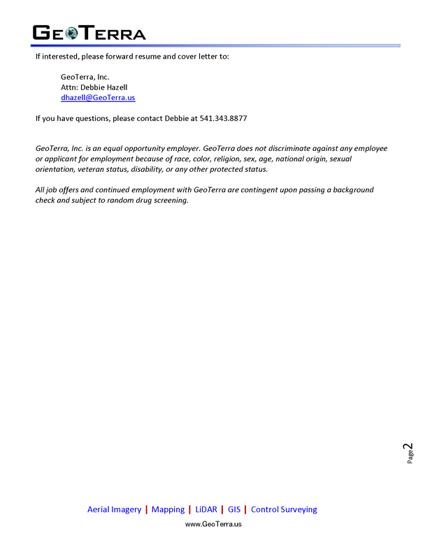
If interested, please forward resume and cover letter to: GeoTerra, Inc. Attn: Debbie Hazell [email protected] If you have questions, please contact Debbie at 541.343.8877 GeoTerra, Inc. is an equal opportunity employer. GeoTerra does not discriminate against any employee or applicant for employment because of race, color, religion, sex, age, national origin, sexual orientation, veteran status, disability, or any other protected status. All job offers and continued employment with GeoTerra are contingent upon passing a background check and subject to random drug screening. |
Categories
All
Archives
June 2024
|


 RSS Feed