 The Port of Tacoma is looking for a GIS Intern to start around June 1
(application deadline is April 15). Salary is $15-$18/hr. Visit http://portoftacoma.com/internships for details.  Gain hands-on experience in public land use areas throughout Nevada, and learn the issues around recreational use of public lands, partake in summer restoration, invasive species removal, pulling mining claim stakes, and carrying out recreational trail work. Ideal for students of Environmental science/Ecology or related fields.
Three six-week internships: Mining Post Sensitive species hazard removal: Several species of birds have attempted to build nests in thousands of hollow, mine claim stakes throughout Nevada, were accidentally trapped, and expired. Activities will include establishing transects, locating and removing posts, collecting specimen remains, identifying species, and collecting and reporting data. Technical skills gained will include: maintaining field safety, off-trail navigation, GIS data collection, avian species identification, and camping and working in the backcountry using low-impact principles. Recreational trail mapping, signing and restoration: Activities will include mapping, sign installation, trail maintenance, and trail restoration. Technical skills gained will include: maintaining field safety, off-trail navigation, use of specialized tools, mapping, collecting GIS data, and camping and working in the backcountry using low-impact principles. Noxious weed removal and native restoration: Activities will include species identification and removal by physical and chemical methods and restoration of native plants. Technical skills gained will include: maintaining field safety, off-trail navigation, plant species identification, data collection and reporting, knowledge of use and effects of biocides, and re-establishment methodology of plant communities. Timeframe: May 20 – June 28, 2013 Compensation: There will be a per diem of $105 per week. Lodging is available at no charge Requirements: Interest in environmental science, Enjoy working and camping outdoors, Enjoy working in a team; Mature, energetic, dependable and self-motivated, Capable of performing physical/manual duties and able to lift 25 pounds, Able to hike in varying terrain for up to eight hours per day Contact: Alicia Karafa, Phone: 775-674-5494, E-mail: AKarafa@thegreatbasininstitute.org, Website: www.TheGreatBasinInstitute.org  Organization: City of Philadelphia, Division of Aviation
Title: GIS Manager – Philadelphia International Airport Location: Philadelphia, PA (City residency required within 6 months of appointment) Application Deadline: March 8, 2013 Position Description: The City of Philadelphia, Division of Aviation is searching for a GIS Manager for the Philadelphia International Airport. PHL is the 9th busiest airport in the nation and about to begin a $6.4 billion Capacity Enhancement Program (CEP) that will be completed in phases over the next 13 years. This is specialized geographic information systems work with responsibility for direction of the planning, design, maintenance, budget, consultant management and production of geographic data and mapping. An employee in this position directs the activities of subordinate GIS specialists, technicians, and consultants engaged in creating and editing geographic data bases and generating resultant map and other relevant geographic information for departmental analysis, management, publication and presentation needs. Conferring with Airport division managers to ascertain their geographic information needs is a significant aspect of the work. Work includes responsibility for managing the production of maps, publications, graphics, and presentation material. Work is performed under the general direction of an administrative superior. Minimum Qualifications:
For full job description and application details: https://phila.peopleadmin.com/postings/3115 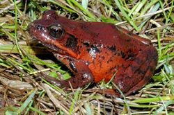 PSU ASPRS Winter 2013 Colloquium
"Developing a Breeding Habitat Suitability Model for Northern Red-legged Frog in the Portland Metro Region" Josh Faber-Hammond, M.S. Washington State University, Adjunct Research Assistant, PSU Friday, Mar 8th, 2013, 12:00 noon - 1:00 pm. Portland State University, Cramer Hall, Room 413 Come out for an hour-long discussion on this important research. Free refreshments! All are welcome. Sponsored by the Columbia River Region American Society for Photogrammetry and Remote Sensing (ASPRS)  GIS TECHNICAL LEAD
Eugene Water & Electric Board, Eugene, Oregon Closes: Friday, March 8, 2013 The Eugene Water & Electric Board (EWEB) seeks an experienced GIS professional to coordinate and lead the GIS function of the organization. The successful candidate will conduct, support and lead the delivery, testing, configuration and customization of GIS solutions for the management of Electric, Water and Telecommunication networks. This position performs the role of database and system administrator for GIS applications, and acts as the primary internal developer of GIS applications to engineering and operational business units. The GIS Lead will solve information technology and data-quality problems proactively and collaboratively with other GIS staff members. EWEB offers employees a unique working culture where public service is combined with development opportunities that support employee growth and enhance job performance. Our employees work in a relaxed environment where creativity, innovation, involvement, teamwork, and diversity are supported and encouraged. EWEB offers a comprehensive benefit package, including health care, vacation and sick leave, pension, holidays, tuition reimbursement, an on-site fitness center and child development center. For more information please go to the following link: http://agency.governmentjobs.com/eweb/default.cfm  If you are looking for classes this spring to count towards your GIS certificate electives OR looking for GIS professional development, there are two exciting opportunities!
Geo 221: Field Geography - The Local Landscape This spring the Geo 221 will work with PSU to conduct research, collect data, and create maps as part of the "Cultural Atlas of Portland." Our specific focus will be on mapping personal geographies within Portland, and psychogeography topics such as smell, sight (colors), sound, and emotions. The course provides an opportunity to learn Geographic field research methods, mapping, geographic information systems (GIS), and cartographic principles. Geo 299E: GIS Programming GIS Programming introduces the fundamentals of programming within the context of Geographic Information Systems (GIS). Using ESRI's ArcGIS as the software platform, the course covers concepts used in automating mapping procedures, handling different types of data, and building custom functions. Provides opportunities to understand the dynamic inner workings of GIS using Python programming language.  Invasive Species Internship
Project Location: 8600 NE 117th Avenue, Vancouver, Washington 98668 Start date: Position available starting in June. Full-time start date flexible. Position Summary: The watershed enhancement program at Clark Public Utilities began in 1992 and has grown to become a regionally recognized environmental restoration effort. Since the program’s inception, volunteers from a variety of backgrounds have planted over 700,000 native trees to bring salmon back to Salmon Creek. Unfortunately a variety of non-native invasive plant species threaten these important riparian ecosystems. The Invasive Species Intern will support the Utilities’ Eradication Nation program. This program is focused on controlling invasive Japanese knotweed and other invasive plant species in the Salmon Creek watershed. This internship will provide the opportunity to develop a number of natural resource management skills that focus on invasive species control. General Responsibilities (vary based on time of year and include, but are not limited to):
Click here to download the complete job description and application details. 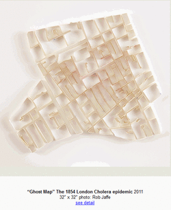 Matthew Pitcon is a Portland-based artist who has a a wide collection of 'urban-narratives'.
Here is an excerpt from his Artist Statement: "Cities are often described as living organisms; viewed as subject rather than object. Matthew Picton engages with this tradition of humanising the city by deconstructing the clean, uncompromising aesthetic of the cartographic city plan and imbuing it with the unique history and culture of each place." Check out his work: http://matthewpicton.com/ |
Categories
All
Archives
March 2024
|
 RSS Feed