 Location: San Diego, California, United States
Posted: 03-06-2013 Employment Type: Full time Job ID: 8374 The GIS Support Technician is an entry-level technical position. Technicians provide customer support of our product solutions to our end users. Technicians also have a secondary role working collaboratively with a project team on multiple phases of GIS application development and implementation. The GIS Support Technician works under the supervision of the Customer Support Manager. Responsibilities • Provide high-quality phone support to clients to help them solve technical problems quickly and effectively • Document technical support issues in a centralized database • Communicate and document end user suggestions such as software functionality recommendations to staff • Assist the project implementation team with various technical aspects of the GIS application development process to include, but not limited to: data collection, geocoding, queries, report writing, and application testing • Perform software testing to troubleshoot issues and evaluate solutions • Demonstrate continual enrichment of Omega product knowledge and understanding of end user needs • Conduct on-going professional self-development to support changes and enhancements of the project management processes Experience and Professional Qualifications • A Bachelor’s degree or equivalent in geography, GIS, or other closely related field • At least one year of experience with GIS, preferably using ESRI's ArcGIS software platform • Basic understanding of the principles and concepts of GIS, in addition to its uses and applications • Familiarity with technical terms and the ability to communicate technical information clearly and concisely • Customer service/software support experience preferred • Ability to function in a dynamic environment subject to impromptu changes in schedules and priorities If you see yourself excelling in this position, please send your resume to resume@theomegagroup.com and reference job TOG116. The Omega Group offers medical, dental, vision, life insurance and a company 401K program. The Omega Group, Inc. is an Equal Opportunity Employer.  Position: GIS Analyst and Spatial Data Manager
Project: Ontario’s Northern Boreal Landscape Reports To: Ontario’s Northern Boreal Landscape Leader Job type: Full-time 6 month position (potential to extend) Location: Flexible within Ontario (WCS Canada Office in Toronto or Peterborough, or a home office location in Ontario) Closing date: 29 March 2013 Anticipated start date: 1 June 2013 (or sooner if possible) Salary: Commensurate with experience Position Summary: The GIS Analyst and Spatial Data Manager is responsible for technical and applied geospatial support that addresses the objectives of WCS Canada’s Ontario Northern Boreal Landscape Program (http://www.wcscanada.org/WhatWeDo/OntarioNorthernBoreal.aspx). The program is focused geographically on Ontario’s Far North developing applied- and field-based research on terrestrial and aquatic socio-ecological systems to address conservation needs in this large, intact landscape. Information generated by the program is used to address and improve land use planning processes, environmental assessment, and conservation in Ontario’s Far North with decision-makers in Government and First Nations and other stakeholders. The position is primarily aimed at providing geospatial support to help develop solutions for conserving the landscape as well as communicating issues and solutions to a broad range of decision-makers and stakeholders. Position Objectives: This position will be responsible for providing technical and applied geospatial support to team members of the Ontario Northern Boreal Landscape program. Specific objectives include:
Principal Responsibilities:
Required Qualifications:
About WCS Canada WCS Canada was established as a Canadian conservation organization in July 2004. Our mission is to conserve wildlife and wildlands by improving our understanding of and seeking solutions to critical problems that threaten key species and large wild ecosystems throughout Canada. We implement and support comprehensive field studies that gather information on wildlife needs and then seek to resolve key conservation problems by working with a broad array of stakeholders. We also provide technical assistance and biological expertise to local groups and agencies that lack the resources to tackle conservation concerns. WCS Canada is independently registered and managed, while retaining a strong collaborative working relationship with sister WCS programs in more than 55 nations, including an integrated North America Program. The Wildlife Conservation Society (www.wcs.org) is a recognized global leader in conservation and for more than a century has worked in North America promoting actions such as bison reintroduction, pioneering field studies, parks creation, and legislation to protect endangered wildlife. To apply: Please send cover letter detailing spatial analysis and conservation interests and experience and Curriculum Vitae to WCS Canada by email, fax or mail: By email: wcscanada@wcs.org By fax: 416-850-9040 By mail: Human Resources Wildlife Conservation Society Canada 720 Spadina Avenue, Suite #600, Toronto, Ontario, Canada M5S 3B3 For more information, contact WCS Canada Assistant Director, Gillian Woolmer (gwoolmer@wcs.org).  The Azuero Earth Project just opened a position in Forestry - GIS to
work in the project's main office in Pedasí, Panamá. The position description and some information about the project can be found in the following link: http://azueroearthproject.org/wp-content/uploads/2012/08/13-01-24DoAFposition_description_fin.pdf  Multnomah County's Department of Community Services is currently seeking a GIS Technician to join the Road Services Division on a Water Quality Program/Asset Management project. This is a full-time, entry level position which provides an excellent opportunity for career development and skill building.
The GIS Technician supports the storm water and road asset mapping effort. The position functions primarily as a GIS software technician to create and edit storm water drainage system features and delineate drainage areas in ArcGIS environment. Other essential functions include verifying assets in the field, importing data from AutoCAD or other data formats, creating maps, managing data in spreadsheets and databases, and periodically preparing reports. Please post this link to the recruitment posting: http://agency.governmentjobs.com/multnomah/default.cfm. See recruitment #6231-04. Deadline to apply is Friday, March 22, 2013. Tomorrow, March 13th is the 2nd Wednesday of the month,
So it is time to have our monthly Happy Hour. This month the Columbia River Brew Pub has been suggested. Located just off of Broadway and Sandy 1728 NE 40th Ave Portland, OR 97212 http://www.columbiariverbrewpub.com/home/  General Description:
Atlas 10 is seeking an energetic, Independent, detail orientated individual to assist with the day-to-day GIS data collection activities. This person should be prepared to work in a fast-paced team environment, and will perform hands-on surveying activities for commercial and industrial centers. This individual must be willing to work independently or in paired teams. Final candidates will be subject to a background check, and proof of drivers license and vehicle insurance. Essential duties & responsibilities include but are not limited to: 90% Data Collection & Field Survey
Essential Knowledge, Skills & Education: Education & Work Experience:
Hours: 40+ hours per week To apply for this job: http://atlasten.hireology.com/careers 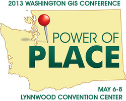 2013 Washington GIS Conference
Monday, May 06, 2013 - Wednesday, May 08, 2013 Lynnwood Convention Center 3711 196th Street S.W Lynnwood, Washington 98284 United States 1-888-778-7155 WAURISA Contacts Email: conference2013@waurisa.org For full conference information: http://www.regonline.com/Register/Checkin.aspx?EventID=1170445  Interactive, animated, Map Projection mayhem. Have fun with it!
https://www.jasondavies.com/maps/transition/ 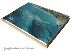 Not digital 3D models, but ones that you can hold and touch. Solid Terrain Modeling Inc. makes geospatially accurate 3D terrain models for museums, municipalities, etc. Check it out!
http://www.solidterrainmodeling.com/  Frank Biasi's will be presenting a webinar -- Integrating Multimedia and Maps to Tell Stories and Engage the Public -- next Wednesday, March 13th at 12 noon, Eastern Time. Frank is the Director of Digital Development with National Geographic Maps and he has a lot of fascinating conservation GIS information to share with us. Please click here for more details and follow the instructions below to join the discussion. Topic: Integrating Multimedia and Maps Date: Wednesday, March 13, 2013 Time: 12:00 pm, Eastern Daylight Time (New York, GMT-04:00) Meeting Number: 825 742 753 Meeting Password: WCS4scgis ------------------------------------------------------- To join the online meeting (Now from mobile devices!) ------------------------------------------------------- 1. Go to https://nethope.webex.com/nethope/j.php?ED=181079912&UID=0&PW=NYTQwN2QzNzVm&RT=MiMxMQ%3D%3D 2. If requested, enter your name and email address. 3. If a password is required, enter the meeting password: WCS4scgis 4. Click "Join". To view in other time zones or languages, please click the link: https://nethope.webex.com/nethope/j.php?ED=181079912&UID=0&PW=NYTQwN2QzNzVm&ORT=MiMxMQ%3D%3D ------------------------------------------------------- To join the teleconference only ------------------------------------------------------- Call-in toll-free number: 1-866-3864210 (US) Call-in number: 1-443-8636601 (US) Show global numbers: https://www.tcconline.com/offSite/OffSiteController.jpf?cc=4140170678 Conference Code: 414 017 0678 ------------------------------------------------------- For assistance ------------------------------------------------------- 1. Go to https://nethope.webex.com/nethope/mc 2. On the left navigation bar, click "Support". You can contact me at: kfisher@wcs.org 1-718-741-8206 |
Categories
All
Archives
March 2024
|
 RSS Feed