|
https://www.linkedin.com/jobs/view/1442508958/?recommendedFlavor=SCHOOL_RECRUIT&refId=dfcc627f-1cf4-4603-8b89-a9dc20bc0ce0&trk=eml-jymbii-organic-job-card&midToken=AQEbMSV32wy3gw&trkEmail=eml-jobs_jymbii_digest-null-2-null-null-hlwaq%7Ek0clunlh%7Eg5-null-jobs%7Eview
Are you well versed in geographic information system software? Are you interested in the impact renewable energy will have on the world? Then this opportunity might be right for you. DNV GL - Energy Advisory is seeking a Geographic Information Systems (GIS) Analyst to join our mutlidiscipline Environmental and Permitting Services (EPS) team. The GIS Analyst will contribute to the company’s studies, reports, and tools through well thought-out mapping products as well as assist with gathering environmental data. This position is based at our office in Portland, OR. Tasks May Include
Requirements Position Qualifications
Company & Business Area Description DNV GL is a global quality assurance and risk management company. Driven by our purpose of safeguarding life, property and the environment, we enable our customers to advance the safety and sustainability of their business. We provide classification, technical assurance, software and independent expert advisory services to the maritime, oil & gas, power and renewables industries. We also provide certification, supply chain and data management services to customers across a wide range of industries. Combining technical, digital and operational expertise, risk methodology and in-depth industry knowledge, we empower our customers’ decisions and actions with trust and confidence. We continuously invest in research and collaborative innovation to provide customers and society with operational and technological foresight. With origins stretching back to 1864 and operations in more than 100 countries, our experts are dedicated to helping customers make the world safer, smarter and greener. DNV GL delivers world-renowned testing and advisory services to the energy value chain including renewables and energy efficiency. Our expertise spans onshore and offshore wind power, solar, conventional generation, transmission and distribution, smart grids, and sustainable energy use, as well as energy markets and regulations. Our experts support customers around the globe in delivering a safe, reliable, efficient, and sustainable energy supply. Equal Opportunity Statement DNV GL is an Equal Opportunity Employer and gives consideration for employment to qualified applicants without regard to gender, religion, race, national or ethnic origin, cultural background, social group, disability, sexual orientation, gender identity, marital status, age or political opinion. Diversity is fundamental to our culture and we invite you to be part of this diversity! https://henkels.referrals.selectminds.com/jobs/gis-technician-998
Henkels & McCoy, Inc. (H&M) is one of the largest privately held utility contracting firms in North America. H&M has over 4,500 active employees in 80 cities with over 90 years of a proven reputation as one of the most reliable, innovative, and diversified firms in the engineering and construction industry. H&M is seeking to employ a GIS Technician to support the Engineering, Construction, and Project Management of the current project. The GIS Technician will report to the GIS Engineer and will be responsible, but not limited to, the following responsibilities:
Minimum Requirements:
Desired skills:
Henkels & McCoy, Inc. is an Equal Opportunity Employer of Minorities, Females, Protected Veterans, and Individuals with Disabilities DISCLAIMER: This is not necessarily an exhaustive list of all responsibilities, duties, skills, efforts, requirements or working conditions associated with the job. While this is intended to be an accurate reflection of the current job requirements, management reserves the right to revise the job or to require that other or different tasks be performed as assigned. Please read the following requirements for background investigation prior to considering employment at Henkels & McCoy.
These are two separate positions. The CIty of Newberg is looking for a Civil Engineering related intern, as well as a Municipal GIS intern. Both are part-time.
https://www.newbergoregon.gov/hr/page/engineering-gis-intern GIS Analyst - Field
Cornea is seeking an experienced GIS Analyst to support its incident operations team. You will use the tools and data sets we’re developing as part of Cornea’s platform to support fire crews on the ground. About Cornea Natural disasters are becoming increasingly severe and costly due to climate change and encroaching development. Incident command teams want better technology to combat these complex and challenging disasters now. At Cornea, we believe that powerful tools in the right hands can radically improve decision-making and better enable an effective response. We provide on-site support to incident command teams at major national and international disasters. Cornea’s field teams use our technology platform to analyze and visualize data in real-time. We empower commanders with the information they need when they need it, saving lives and lowering costs. Cornea’s software platform, built using the latest advances in computation and machine learning, ingests, secures, and displays relevant data in real-time for response planning, management, and deployment. Our field teams work directly at disaster sites through partnerships with federal, state, and international agencies to provide actionable intelligence. During hurricane season, we help emergency managers respond more effectively to rising flood waters, storm surges, and outages. For wildfires, we help incident commanders and firefighters employ resources more effectively to suppress fires earlier and more quickly than ever before. Cornea is backed by Hangar, a public sector-focused investment company. Responsibilities
Requirements
Nice to have
Cornea is an equal opportunity employer. We respect and seek to empower each individual and support diverse cultures, perspectives, skills and experiences within our workforce. We are committed to attracting top talent by providing competitive compensation and benefits. For more information: jobs@cornea.is https://hire.withgoogle.com/public/jobs/hangaris/view/P_AAAAAAEAAJfNc1CkmfpZhB?trackingTag=hangarWeb GIS Career Opportunity with the Washington State Department of Ecology….
https://www.governmentjobs.com/careers/washington/jobs/2558740/spatial-database-administrator-it-data-management-journey ________________________________________________ [The GIS Unit at WA Dept. of Ecology has an exciting job opportunity for a Spatial Database Administrator. Visit careers.wa.gov to view the full advertisement and application. Spatial Database Administrator (Data Management – Journey) Protecting Washington State's environment for current and future generations is what we do every day at Ecology. We are a culture that is invested in making a difference! If you want to join a team that is highly effective, collaborative, has leadership that embraces the value of people, and believes in the fun factor, Ecology is a good fit. The Geographic Information Systems (GIS) Unit within the Information Technology Services Office (ITSO) at our Headquarters building in Lacey, WA is currently looking to fill a permanent Spatial Database Administrator (Data Management – Journey) position. The GIS Unit is a cross-functional team of 8 GIS professionals who are dedicated to providing valuable geospatial solutions, data, and support to staff and citizens to realize Ecology's mission. In this role, you will work in a supportive and professional environment with fantastic people who are passionate about the environment and GIS, understand the importance of work-life balance, and are focused on continual improvement and learning. You will contribute to diverse projects assisting GIS users and providing technical expertise for the entire Ecology enterprise designing, creating, modifying, and reviewing spatial data. You will work closely with internal and external customers and the development teams to improve existing systems and processes. Your work will directly support the creation of new science and policy that is focused on making measurable improvements in the environment of the State of Washington. We are looking for candidates who are business focused that pay attention to detail, enjoy problem solving, and possess excellent people skills that can translate technology speak to non-technical people. Applicants must have proven proficiency with ArcGIS software and spatial data management and design. The candidate must develop relationships and communicate effectively with the development staff and other administrators. As an agency, our mission is to protect, preserve and enhance Washington's environment for current and future generations. We invest in our employees to create and sustain a working environment that encourages creative leadership, effective resource management, teamwork, professionalism and accountability. Some of the key activities of the Spatial Database Administrator are:
This recruitment will remain open until filled. The next screening will be September 17, 2019. In order to be considered for the next screening, please submit an application on or before September 16, 2019. The agency reserves the right to make an appointment any time after the initial screening date. EVREN Northwest, Inc. (ENW), an environmental consulting firm, has an immediate full-time position for a geographer or any geoscientist with a working knowledge of GIS and CAD. 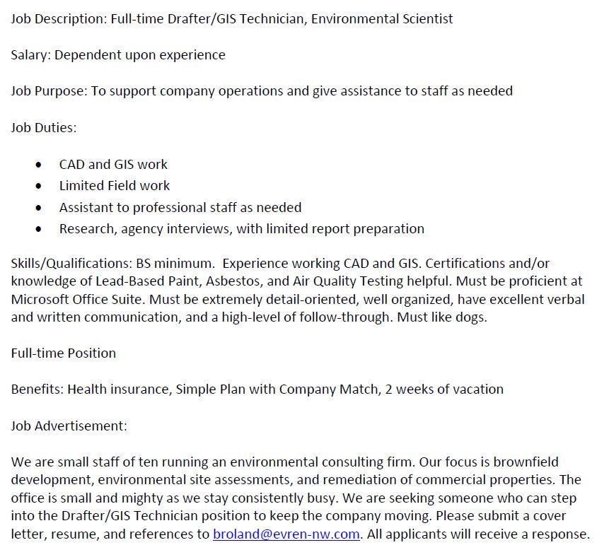 https://www.governmentjobs.com/careers/cowashingtonor/jobs/2548114/geographic-information-systems-gis-technician-ii
Are you looking for new opportunities to embrace your potential and achieve your personal best, every day? If so, Come Lead with Us by joining the Planning and Development Services division within the Department of Land Use and Transportation as a Geographic Information Systems Technician II! The Operations and Maintenance (OPS) division is currently hiring for a highly skilled and self-motivated Geographic Information Systems (GIS) Technician II. The successful candidate will be responsible for tasks related to cartographic production and data maintenance of geospatial datasets pertaining to the maintenance of roads and other transportation assets. Applicants for this position should be familiar with the fundamentals of cartographic production; techniques of data maintenance and be able to quality control their work. The ideal candidate would also have experience in maintaining a geocodable centerline for local government or emergency services, and would have previously worked with linear referencing, both the creation of the routes and the display of the linear referenced events. Experience in local government supporting road or transportation asset datasets is preferred. The work assigned requires significant attention to detail and commitment to accuracy since a portion of the work will be in the support of emergency services and 9-1-1 dispatch. The incumbent in this role must possess excellent communication skills both verbally and written. Individuals must be able to work independently or as part of a team and must have the ability to problem solve and look for opportunities for improvement. Technicians must be comfortable working with a diverse group of stakeholders including engineers, developers, utilities, contractors, other government agencies and citizens. Please use the following link to view the Land Use and Transportation Careers Website: LUT Careers. Washington County offers employees a collaborative culture, work-life balance, and a comprehensive benefits package. Working within Washington County provides daily opportunities to serve and build communities now and into the future. We are an equal opportunity employer with a commitment to a diverse and inclusive workforce. Women, minorities, veterans, and people with disabilities are encouraged to apply. ESSENTIAL JOB DUTIES Duties may include:
|
Categories
All
Archives
March 2024
|
 RSS Feed