|
THE DR. WALTER W. RISTOW PRIZE
FOR AN ACADEMIC PAPER IN THE HISTORY OF CARTOGRAPHY ~~~~~~~~~~~~~~~~~~~~~~~~~ The Dr. Walter W. Ristow Prize, offered annually by the Washington Map Society since 1994, recognizes academic achievement in the History of Cartography. It honors the legacy of the late Dr. Walter W. Ristow, former chief of the Geography & Map Division, Library of Congress, and co-founder and first president of the Washington Map Society. See previous prize winners here THE AWARD The winner of the Ristow Prize Competition shall receive the following: • $1000 cash award • a one-year membership in the Washington Map Society • publication of the paper in The Portolan - Journal of the Washington Map Society • six copies of The Portolan in which the winning paper appears Publication of the winning paper is a requisite for receipt of the Ristow Prize. It is the responsibility of the winning scholar to work with the editor of The Portolan to prepare the paper for publication. The cash award is paid on verification by the editor that the author has provided the necessary assistance to make publication possible. A designation of Honorable Mention may be awarded at the judges' discretion. The recipient of this designation shall receive the following: • a one-year membership in the Washington Map Society • possible publication of the paper in The Portolan - Journal of the Washington Map Society • if published, six copies of The Portolan in which the paper appears Publication of a paper designated for Honorable Mention is at the discretion of the editor of The Portolan, and only with the consent of the author. Publication is not a requisite for receipt of that designation. For more information: http://www.washmapsociety.org/Ristow-Prize.htm The Wilderness Society is looking for Cartographic Designer. The individual in this position will work closely with our national campaigns, philanthropy and GIS staff. The Cartographic Designer will be responsible for creating public-facing cartographic designs that convey our conservation stories and leading the expansion of this work for the organization. Visual design work will require the integration of complex information to generate easy-to-understand map-based products for a range of audiences and media platforms. The work will require message development with multidisciplinary teams, designing and creating cartographic or related visual products and managing the editorial and production process. A successful candidate will be steeped in graphic design and storytelling expertise and have the technical abilities to create map-based products and work with the data that support these graphics.
Please see the full description and application on our website. All applications must be submitted through the website. The PSU Geospatial Information Society student group and PSU Department of Geography will host its third one-day cartography symposium on Tuesday, November 3, in the Smith Memorial Student Union on the PSU campus. We had a full day of presentations, including a keynote address by Jim Meacham of the University of Oregon InfoGraphics Lab.
If you have not already received an evite to register for the event, please send an email to PortlandCartography2015@gmail.com. PRESENTATIONS Keynote address by Jim Meacham, U of O Infographics Lab: Going Deep: Representing the Complexities of Wildlife Migration Sona Andrews — PSU Provost The Language of Maps Francesca Berrini — Artist Aileen Buckley — ESRI What’s Trending with Web GIS Adam Wilbert — CartoGaia From paper map to slippy map: Leveraging map tiles to present large paper documents online Chris Grant, David Banis, and Don Pettit — PSU Geography and Oregon DEQ Standardized Symbologies for the Oregon Incident Response Information System Nicholas Martinelli — Terraseer Designing Together Grant Humphries — TriMet Approaches to Designing a Production Quality Transit Map Lightning Talks — PSU, PCC, and U of O students MAP GALLERY The event will also include a map gallery where students and cartographic professionals from all around the region can display examples of their work. DISCUSSION PANEL We also plan to have a lunchtime discussion panel on the Art and Science of teaching cartography. WHEN Tuesday, Nov 3rd - All Day Smith Memorial Student Union The Central Coast GIS Users Group
(http://www.orurisa.org/2015_Cartography_Symposium) is pleased to invite you to the 2015 Cartography Symposium by the Sea on Friday, September 25th at the Oregon Coast Community College in Newport, OR from 8:30-4:30. Register here: https://ccgisug2015cartography.eventbrite.com Presenters from UofO, ESRI and other organizations will cover a variety of different guidelines and principles to help make your maps the envy of all your friends. We all know a great map when we see it, but what are the principles behind making a good map yourself? GIS has changed map making from a time honored handmade labor, to mass producing large, data filled maps in minutes.This all-day symposium will introduce you to the basic principles of cartography (map making), guidelines you can follow for nearly every map, and tips and tricks for making your map fabulous. More details, including a draft agenda, are available on the symposium website (http://www.orurisa.org/2015_Cartography_Symposium). Lunch and snacks are included in the registration fee ($35). If this registration fee is difficult for you, please contact us for alternate options. In an effort to reduce waste we will not be providing individual bottled water this year. Please consider bringing a reusable water bottle or other container for drinking water during the symposium. We will also have cups available in case you forget. Thank you! January's guest is Dave Mangold, who will speak to us about how to create great cartographic products using QGIS and Inkscape. Attendees of FOSS4G may remember the excellent map that Dave produced for the printed FOSS4G program [2]. Dave has a lot of interesting lessons learned from this map, and new items learned since the conference - please drop in to hear all about it!
From Dave's Description of his map: This map was created entirely from freely available data and open-source software. Data were obtained as shapefile downloads from METRO RLIS. These shapefiles were then loaded into a PostGIS database as spatial tables. The initial map was created in QGIS. The map was then saved in a vector format and finished in InkScape, where label adjustment and creation, feature layering, and annotation were accomplished. On the map, if you look closely at the southern portion of Naito Street (right edge of left panel), you will see a hidden tribute to the free and open-source resources used. [1] http://calagator.org/events/1250467585 [2] https://2014.foss4g.org/wp-content/uploads/mapgallery/orig/150.png Applications for the next round of AAG Cartography Specialty Group Master's Thesis Research Grants are due by November 15, 2014.
Masters students enrolled full time are invited to apply for the CSG Master's Thesis Research Grants. These grants are intended to promote scholarly research in cartography by students enrolled in Geography or a related degree program. Grants are available up to a maximum of $500 and may be used for items necessary and relevant to research, such as travel, materials, equipment, and human subject fees. Deadlines for application are March 15, June 15, and November 15 of each year. Applications and inquiries should be directed to the CSG Non-Academic Director, Sarah Bell, at sbell@esri.com. For more information and the application form, please visit http://www.csun.edu/~hfgeg003/csg/master.html. You can also access that page from the Awards and Competitions section of the main CSG Web site, http://www.csun.edu/~hfgeg003/csg.  The MapStory Foundation is proud to sponsor the Fall Symposium of the American Geographical Society - Geography 2050: Mounting an Expedition to the Future. They are calling it a “multi-year strategic dialog on the vital trends that will reshape our nation and our planet.” And, this inaugural event will be hosted by Columbia University’s Earth Institute, in the historic Low Library Rotunda, on November 19th in NYC. You can learn more about this forward looking dialog at www.geography2050.org, and you can even register and be part of it.
Most of the content within MapStory.org addresses the past and the present. But, in celebration of this unique event, we at MapStory are offering a $1000 prize for whomever posts the best future oriented MapStory about how our world will change by 2050. The use of scientifically validated data on future trends is encouraged. Yet, the narrative elements of the story will be just as important. While the financial incentive of the prize is notable, the winning MapStory will also be played at the Geography 2050 Fall Symposium for the thought leaders in attendance. The content and themes of your MapStory submission do not need to adhere to those of this inaugural event, and instead can cover any trends and underlying factors that you deem to be important to the future of our planet. To participate, just publish your MapStory and tweet it to @Geography2050 with the hasthag #MapStory2050. Deadline for submission is November 15.  NATIONAL GEOGRAPHIC AWARD IN MAPPING
Undergraduate students and masters-degree candidates are invited to apply for the 2014 National Geographic Award in Mapping. This award recognizes student achievement in the art, science, and technology of mapping and seeks to encourage student research. The first place award consists of a cash prize of $900 (U.S.) and the second place award is $300 (U.S.). Winners and honorable mentions also will receive National Geographic atlases or other map products. This award is administered through the Association of American Geographers (AAG) Cartography Specialty Group (CSG). Judging will be completed by representatives from National Geographic and will be based on the technical, aesthetic, and overall quality of the submission. The award winners will be announced at the CSG business meeting at the 2014 AAG Annual Meeting in Tampa, FL. Applying students do not need to be members of the AAG. HOW TO APPLY: Following the strong tradition of production cartography at the National Geographic Society, submission must be in the form of a static map in a vector (e.g., pdf) or raster (e.g., jpg, tiff) format. While group work is eligible for submission, the maximum numbers of students working on a single team is three. Entries must be completed as part of the student's curriculum (i.e., not for a job, including freelance work); the student's cartography instructor must confirm that the work was completed for university credit by completing and scanning the online form. Please include the following in your application package: (1) your map, or a link for downloading your map (latter preferred); (2) a cover page that includes your name, institutional affiliation, degree program (e.g. M.S.), address, phone number, email, and cartography/GIS instructor's name; (3) a one page statement that provides some context of the submission (e.g., its purpose, how it may be used, how it was created, its limitations, etc.) along with a paragraph on how this award will help you with your educational plans; and (4) the completed form signed by your cartography instructor. Please apply by sending all materials digitally to Robert Roth (reroth@wisc.edu). Submissions must be received by March 1st, 2014. For additional details, please visit:http://www.natgeomaps.com/mapawards  Gretchen Peterson, Cartographer and author, has created some video tutorials for using TileMill - a web mapping tool. Check them out: http://www.gretchenpeterson.com/blog/?p=3448 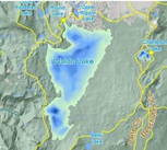 The Portland State University Department of Geography and the Geospatial Information Society student group will be hosting a one-day cartography symposium on 8 November, in the Smith Memorial Student Union on the PSU campus. We have a full day of presentations planned, including a keynote presentation by Stuart Allan of Allan Cartography and Raven Maps.
The event will also include a map gallery where students and cartographic professionals from all around the region will have examples of their work on display. You, too, are welcome to submit a map to be included in the gallery. Although the event is free, we do require pre-registration. If you are planning to attend, please complete the registration form and return it to the indicated email address as soon as you can but no later than noon on Monday, 28 Oct 2013. Two years ago, when we hosted a similar event, registration filled quickly and we had a waiting list. To be assured of a spot, please return your completed registration form promptly. --- Chris Grant (christopher.a.grant@gmail.com) David Banis (dbanis@pdx.edu) |
Categories
All
Archives
March 2024
|
 RSS Feed