 This is to let you know that the 2013 Portland Cartography Symposium will take place on Friday, 8 Nov 2013.
The Portland State University Department of Geography and the Geospatial Information Society student group will be hosting a one-day cartography symposium on 8 November, at the Smith Memorial Student Union on the PSU campus. This event will include a keynote presentation by a distinguished Oregon cartographer, a full day of presentations on a diverse variety of topics related to cartography, and a map gallery. The event will be free, but advance registration will be required. Refreshments will be served. You may remember that a similar event took place two years ago. That event was quite successful, with almost 100 students and professionals from the regional cartographic community participating. At the moment, we would like to get a preliminary headcount of people who might be interested in displaying a map in the map gallery. If you have a map that you would like to submit to the gallery, will you please send a short note to (PortlandCartography2013@gmail.com). Registration for this year's event will begin in October, and we expect the event to fill quickly. More details about the event will be available soon, but if the event interests you, or if you have questions, contact Chris Grant and/or David Banis at (PortlandCartography2013@gmail.com), or at our email addresses noted below. Please share information about this event with other cartographic professionals or cartographically inclined folks, and we hope that we'll see you on 8 Nov! --- Chris Grant (christopher.a.grant@gmail.com) David Banis (dbanis@pdx.edu)  I came across these Cartographic Standards developed by the CDC and thought some of you might be interested to see what they might look like for a government organization.
"In May of 2011, GeoSWG Executive Committee formed the Public Health and Cartography Ad Hoc Committee "to propose cartographic guidelines and best practices to produce high-quality, consistent map products for the public health community." The purpose of these guidelines is to advance the application of geospatial concepts and methods within public health practice and research at CDC/ATSDR." Cartographic Guidelines for Public Health http://gis.cdc.gov/grasp/resources/Cartographic%20Guidelines%20PH%202012%20 with%20Cover%20v3-508c.pdf 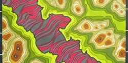 Portland Community College is offering (non-credit) a course in Cartography for Wilderness Exploration.
There will be six class meetings, three lectures and three labs: (all class meetings are on Saturday at Sylvania in HT301 from 1:00 PM - 2:50 PM) If the class is successful we will ...
Students will use existing maps and/or verbal descriptions to pick a place that looks interesting but is not widely known. We'll gather publicly available information and make our own maps using free (or low cost) GIS programs. I hope that we all have a chance to hike and/or scramble to the places we picked and see how closely our maps matched the real world. For some students this may be an introduction to Geographic Information Systems (GIS) that may lead to enrollment in a PCC Geography Degree Program and a career in GIS. 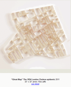 Matthew Pitcon is a Portland-based artist who has a a wide collection of 'urban-narratives'.
Here is an excerpt from his Artist Statement: "Cities are often described as living organisms; viewed as subject rather than object. Matthew Picton engages with this tradition of humanising the city by deconstructing the clean, uncompromising aesthetic of the cartographic city plan and imbuing it with the unique history and culture of each place." Check out his work: http://matthewpicton.com/ Do you love Maps and Portland as much as me?
Ratna Adhar is hosting a map making party on the 19th. Come over and make a mental map of 'your' Portland. How do you see your city? Where do you go and how would you represent the places that matter to you? Extra points for individuality and creativity! The best 15 will be selected for a first Thursday art show in April at a local gallery. Ratna will be getting some supplies for us from @scrapPDX but please bring provisions and feel free to use a medium of your choice. There will be wine and music to catalyze inspiration. Email me with any questions: Ratnanjali.Adhar@gmail.com All submissions due by March 20. This cartography blog was recently brought to my attention - it's a great source for map critique, has lots of maps to looks at, and it quite comical at times. take a look!
http://cartastrophe.wordpress.com/ Thanks Whit for passing this one along...
Here are a few links to John Wesley Powell’s 1890 map of Drainage Districts (Watershed) and the Arid region of the West. Interesting and progressive ideas for that time, and early cartographic representation. http://bigthink.com/strange-maps/489-how-the-west-wasnt-won-powells-water-based-states http://www.aqueousadvisors.com/blog/?p=301 Capitalism Nature Socialism could use the expertise of a cartographer who would be willing to produce gray-scale maps to accompany published manuscripts. The maps would be specific to a manuscript and/or be a single map showing all the places featured in a journal issue. Something akin to the work of Philippe Rekacewicz of Le Monde Diplomatique would be desirable, but the cartographical style sought is fairly open and does not have to be conventional. Due to limited funds, the pay would be relatively meagre, at USD 50 per map (for a maximum of USD 400 per year). If you are interested, please post me a message atengeldis@newpaltz.edu.
Otherwise, cartograpical works are most welcome that cover any of the themes described below and that use approaches similar, for instance, to those of the Counter-Cartographies Collective (http://www.countercartographies.org/). Such work would be treated as any other manuscript in that it would undergo a peer-review process. Unfortunately, cartographical submissions must be in gray-scale only and fit into a standard 22 x 28 cm page (8.5 x 11”). If interested, please submit your work throughhttp://mc.manuscriptcentral.com/rcns. Capitalism Nature Socialism is a journal published by Taylor & Francis four times per year. It is dedicated to promoting ecosocialism and ecofeminism and serves as a forum for red-green politics, left anticapitalist and Indigenous Peoples’ movements, (house/care)workplace struggles, land/community struggles, and related themes (yes, this list departs from that on the official website... working on changing it). Among the journal objectives is to facilitate integrating discussions on working-class, feminist, antiracist, and environmental movements. Works on ecology and socialism are particularly welcome, including from the natural sciences. For the most recent journal content, see http://www.tandfonline.com/toc/rcns20/current. David Imus's winning US Wall Map is getting a lot of press. To listen to the OBP interview with Mr. Imus, go to this Think Out Loud episode:
http://www.opb.org/thinkoutloud/shows/job-cartography/ Registration is now open for the 2011 Portland Cartography Symposium Nov. 4 at Portland State University! We have a full lineup of outstanding presenters and anticipate a vibrant and innovative gallery of map displays.
A registration form, program schedule and information sheet, event flier and campus map are available. To register, complete the registration form and email it to Dan Uthman at uthmand@pdx.edu. The registration deadline is noon Friday, October 21. Space is limited to the first 100 registrants, so register early to reserve your spot. This is a free event. Questions can be directed to event organizers Dan Uthman (uthmand@pdx.edu) and David Banis (dbanis@pdx.edu). |
Categories
All
Archives
March 2024
|
 RSS Feed